Property Record
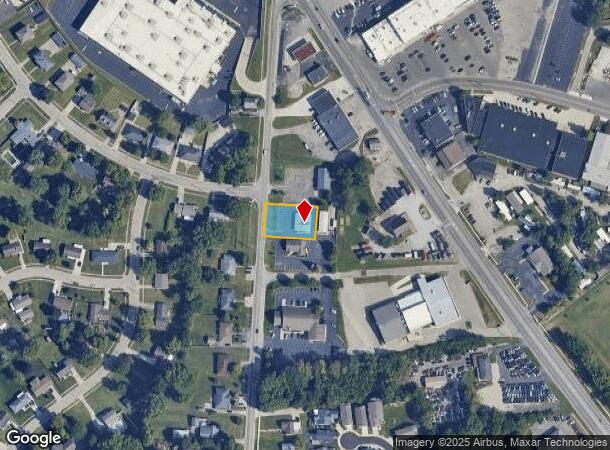
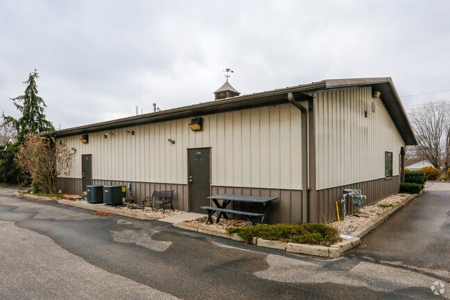
4952 E-F Winton Rd, Fairfield, OH 45014

NEARBY LISTINGS FOR SALE OR LEASE
Property Detail
4952 E-F Winton Rd
A0700-006-000-245
Fairfield
Storebuilding
144 CTR PT OF W PT SEE TIF PCL 245T - FF NORTHEAST-FAIRFIELD TIF
X
Butler
39017C0308F
Ohio
2024
0.36 AC
2025
Butler County
010903
Cincinnati/Dayton
1,800 SF
Cincinnati, OH-KY-IN
DEMOGRAPHICS near 4952 E-F Winton Rd
1 mile
3 mile
5 mile
2024 Total Population
8,031
63,017
160,026
2029 Population
8,127
63,840
161,922
Pop Growth 2024-2029
+ 1.20%
+ 1.31%
+ 1.18%
Average Age
39
40
39
2024 Total Households
3,183
25,147
61,856
HH Growth 2024-2029
+ 1.16%
+ 1.26%
+ 1.32%
Median Household Inc
$55,417
$60,709
$64,511
Avg Household Size
2.40
2.40
2.50
2024 Avg HH Vehicles
2.00
2.00
2.00
Median Home Value
$158,826
$167,563
$175,688
Median Year Built
1972
1974
1975
Nearby Places
Map Layers
Map Styles
 Street
 Aerial
Transit
 Traffic
 Biking
Places
Listings with unknown addresses are not visible on the map
- Restaurants
- Banks
- Shops
- Fitness
- Groceries
PUBLIC TRANSPORTATION
AIRPORT
Cincinnati/Northern Kentucky International
Drive
Walk
Distance
Cincinnati/Northern Kentucky International
60 min
37.1 mi
SALE & LEASE HISTORY
LISTING DATE
SALE/LEASE

May 31, 2019
For Lease
Apr 15, 2019
For Sale
Nearby Properties
Address
Land Use
TOTAL SIZE
Lot Size
Zoning
Address
Land Use
TOTAL SIZE
Lot Size
Zoning
40,006 SF
17.23 AC
Address
Land Use
TOTAL SIZE
Lot Size
Zoning
38,880 SF
20.93 AC
Address
Land Use
TOTAL SIZE
Lot Size
Zoning
28.80 AC
Address
Land Use
TOTAL SIZE
Lot Size
Zoning
1,363,493 SF
75.28 AC
Address
Land Use
TOTAL SIZE
Lot Size
Zoning
14,559 SF
27.50 AC
Address
Land Use
TOTAL SIZE
Lot Size
Zoning
510,080 SF
60.87 AC
Address
Land Use
TOTAL SIZE
Lot Size
Zoning
18.77 AC
Address
Land Use
TOTAL SIZE
Lot Size
Zoning
467,263 SF
27.27 AC
ADV
Address
Land Use
TOTAL SIZE
Lot Size
Zoning
54.77 AC
Address
Land Use
TOTAL SIZE
Lot Size
Zoning
438,182 SF
28.80 AC
Address
Land Use
TOTAL SIZE
Lot Size
Zoning
629,044 SF
35.83 AC
Address
Land Use
TOTAL SIZE
Lot Size
Zoning
28.47 AC
Address
Land Use
TOTAL SIZE
Lot Size
Zoning
319,568 SF
23.73 AC
Address
Land Use
TOTAL SIZE
Lot Size
Zoning
357,452 SF
26.77 AC
Address
Land Use
TOTAL SIZE
Lot Size
Zoning
279,161 SF
28.02 AC
Address
Land Use
TOTAL SIZE
Lot Size
Zoning
287,433 SF
23.36 AC
Address
Land Use
TOTAL SIZE
Lot Size
Zoning
28,343 SF
35.08 AC
Address
Land Use
TOTAL SIZE
Lot Size
Zoning
30.51 AC
Address
Land Use
TOTAL SIZE
Lot Size
Zoning
50,753 SF
19.74 AC
Address
Land Use
TOTAL SIZE
Lot Size
Zoning
24.45 AC
Address
Land Use
TOTAL SIZE
Lot Size
Zoning
183,864 SF
25.85 AC
Address
Land Use
TOTAL SIZE
Lot Size
Zoning
215,969 SF
16.08 AC
ADV
Address
Land Use
TOTAL SIZE
Lot Size
Zoning
147,898 SF
15.34 AC
Address
Land Use
TOTAL SIZE
Lot Size
Zoning
22.02 AC
Address
Land Use
TOTAL SIZE
Lot Size
Zoning
412,814 SF
23.92 AC
Address
Land Use
TOTAL SIZE
Lot Size
Zoning
124,549 SF
9.75 AC
Address
Land Use
TOTAL SIZE
Lot Size
Zoning
150,620 SF
13.73 AC
Address
Land Use
TOTAL SIZE
Lot Size
Zoning
178,912 SF
13.86 AC
Address
Land Use
TOTAL SIZE
Lot Size
Zoning
462,994 SF
25.63 AC
Address
Land Use
TOTAL SIZE
Lot Size
Zoning
333,379 SF
22.22 AC
The World's #1 Commercial Real Estate Marketplace
Connect with us
© 2026 CoStar Group
The information above has been obtained from sources believed reliable. While we do not doubt its accuracy we have not verified it and make no guarantee, warranty or representation about it. It is your responsibility to independently confirm its accuracy and completeness. Any projections, opinions, assumptions, or estimates used are for example only and do not represent the current or future performance of the property. The value of this transaction to you depends on tax and other factors which should be evaluated by your tax, financial, and legal advisors. You and your advisors should conduct a careful, independent investigation of the property to determine to your satisfaction the suitability of the property for your needs.