Property Record
4953 Lexington Rd, Rayle, GA 30660


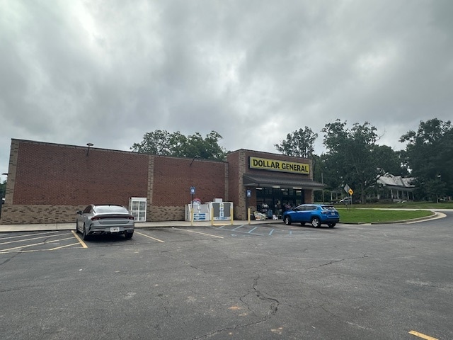
This Property Is For Sale
Property Detail
4953 Lexington Rd
Wholesaleoutletdiscountstore
PB 14: 40 DOLLAR GENERAL
002
WILKES
B and X Area of moderate flood hazard, usually the area between the limits of the 100-year and 500-year floods.
Georgia
2025
1.52 AC
2025
Georgia Northeast
010102
Other Market Areas
7,613 SF
016B- -013
NEARBY LISTINGS FOR SALE OR LEASE
-
-
View all Rayle listings for sale on LoopNet.com
DEMOGRAPHICS near 4953 Lexington Rd
1 mile
3 mile
5 mile
2025 Total Population
215
815
1,339
2030 Population
224
848
1,392
Pop Growth 2025-2030
+ 4.19%
+ 4.05%
+ 3.96%
Average Age
44
45
45
2025 Total Households
87
333
549
HH Growth 2025-2030
+ 4.60%
+ 4.20%
+ 4.01%
Median Household Inc
$63,750
$65,543
$65,625
Avg Household Size
2.40
2.40
2.40
2025 Avg HH Vehicles
2.00
2.00
2.00
Median Home Value
$206,667
$198,836
$192,948
Median Year Built
1984
1982
1981
Nearby Places
Map Layers
Map Styles
 Street
 Aerial
Layers
 Traffic
 Biking
Places
Listings with unknown addresses are not visible on the map
- Restaurants
- Banks
- Shops
- Fitness
- Groceries
Nearby Properties
Address
Land Use
TOTAL SIZE
Lot Size
Zoning
Address
Land Use
TOTAL SIZE
Lot Size
Zoning
710 AC
001
Address
Land Use
TOTAL SIZE
Lot Size
Zoning
744 SF
206.85 AC
001
Address
Land Use
TOTAL SIZE
Lot Size
Zoning
7,500 SF
20 AC
001
Address
Land Use
TOTAL SIZE
Lot Size
Zoning
222.97 AC
004
Address
Land Use
TOTAL SIZE
Lot Size
Zoning
361.80 AC
004
Address
Land Use
TOTAL SIZE
Lot Size
Zoning
483.06 AC
004
Address
Land Use
TOTAL SIZE
Lot Size
Zoning
4,000 SF
6 AC
001
Address
Land Use
TOTAL SIZE
Lot Size
Zoning
2,052 SF
293.34 AC
004
Address
Land Use
TOTAL SIZE
Lot Size
Zoning
393.20 AC
004
Address
Land Use
TOTAL SIZE
Lot Size
Zoning
305.12 AC
001
Address
Land Use
TOTAL SIZE
Lot Size
Zoning
3,748 SF
4.86 AC
001
Address
Land Use
TOTAL SIZE
Lot Size
Zoning
261.08 AC
004
Address
Land Use
TOTAL SIZE
Lot Size
Zoning
61.11 AC
004
Address
Land Use
TOTAL SIZE
Lot Size
Zoning
132 AC
004
Address
Land Use
TOTAL SIZE
Lot Size
Zoning
279.66 AC
004
Address
Land Use
TOTAL SIZE
Lot Size
Zoning
313.30 AC
001
Address
Land Use
TOTAL SIZE
Lot Size
Zoning
202.34 AC
004
Address
Land Use
TOTAL SIZE
Lot Size
Zoning
215.24 AC
001
Address
Land Use
TOTAL SIZE
Lot Size
Zoning
1,200 SF
3.09 AC
001
Address
Land Use
TOTAL SIZE
Lot Size
Zoning
228.92 AC
004
Address
Land Use
TOTAL SIZE
Lot Size
Zoning
248 AC
004
Address
Land Use
TOTAL SIZE
Lot Size
Zoning
3,637 SF
170 AC
004
Address
Land Use
TOTAL SIZE
Lot Size
Zoning
135.21 AC
001
Address
Land Use
TOTAL SIZE
Lot Size
Zoning
2,353 SF
186 AC
004
Address
Land Use
TOTAL SIZE
Lot Size
Zoning
2,550 SF
65 AC
004
Address
Land Use
TOTAL SIZE
Lot Size
Zoning
159.28 AC
004
Address
Land Use
TOTAL SIZE
Lot Size
Zoning
15,250 SF
4.99 AC
001
Address
Land Use
TOTAL SIZE
Lot Size
Zoning
182 AC
004
Address
Land Use
TOTAL SIZE
Lot Size
Zoning
187 AC
004
The World's #1 Commercial Real Estate Marketplace
Connect with us
© 2026 CoStar Group
The information above has been obtained from sources believed reliable. While we do not doubt its accuracy we have not verified it and make no guarantee, warranty or representation about it. It is your responsibility to independently confirm its accuracy and completeness. Any projections, opinions, assumptions, or estimates used are for example only and do not represent the current or future performance of the property. The value of this transaction to you depends on tax and other factors which should be evaluated by your tax, financial, and legal advisors. You and your advisors should conduct a careful, independent investigation of the property to determine to your satisfaction the suitability of the property for your needs.