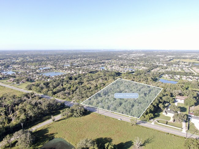
Property Record
4955 Fort Hamer Rd, Parrish, FL 34219


Save to a Folder
{{folder.Name}}
{{folder.ListingIds.length}} Properties
{{folder.ListingIds.length}} Property
Create a New Folder
Property Detail
4955 Fort Hamer Rd
4897-1010-3
THE S1/2 OF E1/2 OF SE1/4 OF SW1/4 OF SEC 32; LESS THE N 185 FT THEREOF & LESS E 40 FT FOR RD R/W DESC IN ORB 132 P 539 & BEING FURTHER DESC IN OR 1077 P 3490 PRMCF PI#4897.1010/3
Vacantlandnec
MANATEE
A GENERAL
Florida
AE The base floodplain where base flood elevations are provided. AE Zones are now used on new format FIRMs instead of A1-A30 Zones.
7.50 AC
0
Manatee
2026
Tampa/St Petersburg
001913
North Port-Bradenton-Sarasota, FL
NEARBY LISTINGS FOR SALE OR LEASE
DEMOGRAPHICS near 4955 Fort Hamer Rd
1 mile
3 mile
5 mile
2025 Total Population
6,070
30,631
82,419
2030 Population
6,818
35,032
94,437
Pop Growth 2025-2030
+ 12.32%
+ 14.37%
+ 14.58%
Average Age
43
44
46
2025 Total Households
2,222
11,427
31,589
HH Growth 2025-2030
+ 12.51%
+ 14.26%
+ 14.27%
Median Household Inc
$99,339
$108,347
$105,980
Avg Household Size
2.70
2.60
2.50
2025 Avg HH Vehicles
2.00
2.00
2.00
Median Home Value
$427,059
$453,490
$460,492
Median Year Built
2009
2010
2009
Nearby Places
Map Layers
Map Styles
 Street
 Aerial
Layers
 Traffic
 Biking
Places
Listings with unknown addresses are not visible on the map
- Restaurants
- Banks
- Shops
- Fitness
- Groceries
PUBLIC TRANSPORTATION
AIRPORT
Sarasota/Bradenton International
Drive
Walk
Distance
Sarasota/Bradenton International
39 min
20.3 mi
St Pete-Clearwater International
Drive
Walk
Distance
St Pete-Clearwater International
56 min
41.4 mi
Tampa International
Drive
Walk
Distance
Tampa International
66 min
44.6 mi
Freight Ports
Port Manatee
Drive
Walk
Distance
Port Manatee
24 min
13.1 mi
SALE & LEASE HISTORY
LISTING DATE
SALE/LEASE

Oct 07, 2019
For Sale
Nearby Properties
Address
Land Use
TOTAL SIZE
Lot Size
Zoning
Address
Land Use
TOTAL SIZE
Lot Size
Zoning
Address
Land Use
TOTAL SIZE
Lot Size
Zoning
Address
Land Use
TOTAL SIZE
Lot Size
Zoning
81.56 AC
Address
Land Use
TOTAL SIZE
Lot Size
Zoning
66,063 SF
9.24 AC
PD-C
Address
Land Use
TOTAL SIZE
Lot Size
Zoning
9,964 SF
198.79 AC
Address
Land Use
TOTAL SIZE
Lot Size
Zoning
120.34 AC
Address
Land Use
TOTAL SIZE
Lot Size
Zoning
Address
Land Use
TOTAL SIZE
Lot Size
Zoning
43,464 SF
14.47 AC
VIL VILLAG
Address
Land Use
TOTAL SIZE
Lot Size
Zoning
190.90 AC
PD-R
Address
Land Use
TOTAL SIZE
Lot Size
Zoning
50,580 SF
5.97 AC
Address
Land Use
TOTAL SIZE
Lot Size
Zoning
103,489 SF
3.88 AC
VIL VILLAG
Address
Land Use
TOTAL SIZE
Lot Size
Zoning
99,771 SF
2.20 AC
PD-MU
Address
Land Use
TOTAL SIZE
Lot Size
Zoning
61.03 AC
Address
Land Use
TOTAL SIZE
Lot Size
Zoning
28,413 SF
5.40 AC
RSMH-6
Address
Land Use
TOTAL SIZE
Lot Size
Zoning
11,313 SF
21.81 AC
Address
Land Use
TOTAL SIZE
Lot Size
Zoning
53,851 SF
6.32 AC
Address
Land Use
TOTAL SIZE
Lot Size
Zoning
30,101 SF
13.44 AC
PD-C
Address
Land Use
TOTAL SIZE
Lot Size
Zoning
36,700 SF
17 AC
A-1 SUBURB
Address
Land Use
TOTAL SIZE
Lot Size
Zoning
Address
Land Use
TOTAL SIZE
Lot Size
Zoning
109.06 AC
Address
Land Use
TOTAL SIZE
Lot Size
Zoning
98.57 AC
A GENERAL
Address
Land Use
TOTAL SIZE
Lot Size
Zoning
38,246 SF
3.92 AC
Address
Land Use
TOTAL SIZE
Lot Size
Zoning
3.11 AC
Address
Land Use
TOTAL SIZE
Lot Size
Zoning
4.07 AC
Address
Land Use
TOTAL SIZE
Lot Size
Zoning
53,448 SF
3 AC
PD-C
Address
Land Use
TOTAL SIZE
Lot Size
Zoning
Address
Land Use
TOTAL SIZE
Lot Size
Zoning
16 AC
PD-MU
Address
Land Use
TOTAL SIZE
Lot Size
Zoning
13.62 AC
PD-R
Address
Land Use
TOTAL SIZE
Lot Size
Zoning
9,806 SF
4.04 AC
VIL VILLAG
Address
Land Use
TOTAL SIZE
Lot Size
Zoning
4,908 SF
2 AC
PD-MU
The World's #1 Commercial Real Estate Marketplace
Connect with us
© 2026 CoStar Group
The information above has been obtained from sources believed reliable. While we do not doubt its accuracy we have not verified it and make no guarantee, warranty or representation about it. It is your responsibility to independently confirm its accuracy and completeness. Any projections, opinions, assumptions, or estimates used are for example only and do not represent the current or future performance of the property. The value of this transaction to you depends on tax and other factors which should be evaluated by your tax, financial, and legal advisors. You and your advisors should conduct a careful, independent investigation of the property to determine to your satisfaction the suitability of the property for your needs.