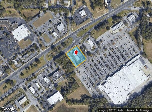
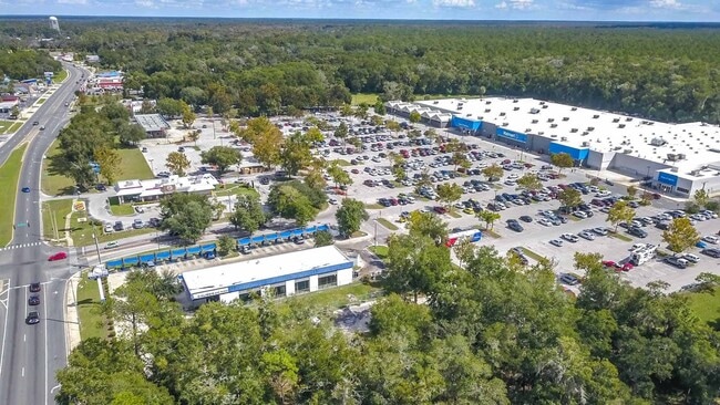
Property Record
4956 E Silver Springs Blvd, Ocala, FL 34470
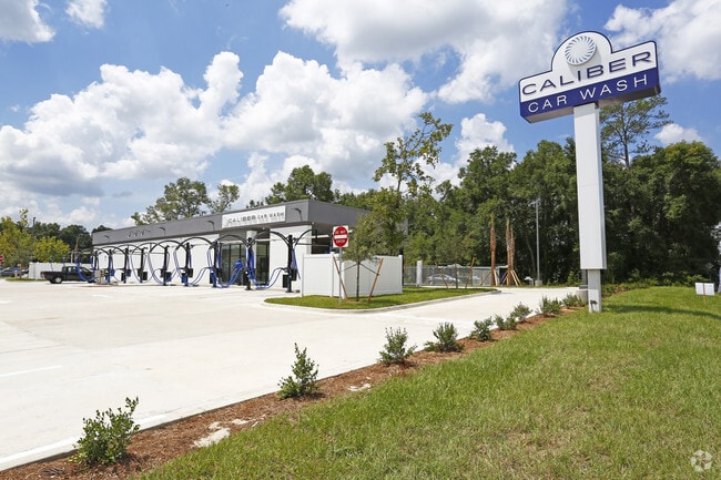

This Property Is For Sale
NEARBY LISTINGS FOR SALE OR LEASE
Property Detail
4956 E Silver Springs Blvd
24166-002-00
SEC 01 TWP 15 RGE 22 COM S 1/4 TH S 89-42-49 W 583.75 FT TH N 36-03-47 W 432.09 FT TH S 53-58-13 W 47.38 FT TH N 36-03-47 W 391.76 FT TO POB TH S 10-14-18 W 29.74 FT TH S 53-56-21 W 171.27 FT TH N 36-03-47 W 238.80 FT TH N 53-56-13 E 192.77 FT TH S 3
Carwash
Marion
X
Florida
12083C0529E
1.05 AC
2025
Greater Ocala
2025
Ocala
002201
Ocala, FL
4,477 SF
DEMOGRAPHICS near 4956 E Silver Springs Blvd
1 mile
3 mile
5 mile
2024 Total Population
4,420
31,947
75,970
2029 Population
5,096
35,927
85,408
Pop Growth 2024-2029
+ 15.29%
+ 12.46%
+ 12.42%
Average Age
41
42
41
2024 Total Households
2,055
13,765
31,039
HH Growth 2024-2029
+ 15.38%
+ 12.48%
+ 12.43%
Median Household Inc
$45,028
$55,614
$58,531
Avg Household Size
2.10
2.30
2.40
2024 Avg HH Vehicles
1.00
2.00
2.00
Median Home Value
$142,224
$165,540
$186,872
Median Year Built
1989
1982
1983
Nearby Places
Map Layers
Map Styles
 Street
 Aerial
Transit
 Traffic
 Biking
Places
Listings with unknown addresses are not visible on the map
- Restaurants
- Banks
- Shops
- Fitness
- Groceries
Nearby Properties
Address
Land Use
TOTAL SIZE
Lot Size
Zoning
Address
Land Use
TOTAL SIZE
Lot Size
Zoning
205,664 SF
22.56 AC
B5
Address
Land Use
TOTAL SIZE
Lot Size
Zoning
17,071 SF
69.56 AC
MH
Address
Land Use
TOTAL SIZE
Lot Size
Zoning
116,035 SF
38.20 AC
GU
Address
Land Use
TOTAL SIZE
Lot Size
Zoning
111,395 SF
13 AC
B2
Address
Land Use
TOTAL SIZE
Lot Size
Zoning
30,334 SF
34.53 AC
GU
Address
Land Use
TOTAL SIZE
Lot Size
Zoning
46,293 SF
11.30 AC
GU
Address
Land Use
TOTAL SIZE
Lot Size
Zoning
78,280 SF
12.54 AC
R3
Address
Land Use
TOTAL SIZE
Lot Size
Zoning
203,940 SF
29.65 AC
SC
Address
Land Use
TOTAL SIZE
Lot Size
Zoning
134,827 SF
14.83 AC
SC
Address
Land Use
TOTAL SIZE
Lot Size
Zoning
192,553 SF
21.18 AC
SC
Address
Land Use
TOTAL SIZE
Lot Size
Zoning
107,993 SF
66.76 AC
GU
Address
Land Use
TOTAL SIZE
Lot Size
Zoning
10,552 SF
51.60 AC
PRV
Address
Land Use
TOTAL SIZE
Lot Size
Zoning
134,890 SF
18.90 AC
B4
Address
Land Use
TOTAL SIZE
Lot Size
Zoning
35,356 SF
6.14 AC
R3
Address
Land Use
TOTAL SIZE
Lot Size
Zoning
762 SF
38.07 AC
PMH
Address
Land Use
TOTAL SIZE
Lot Size
Zoning
68,182 SF
22.64 AC
A1
Address
Land Use
TOTAL SIZE
Lot Size
Zoning
81,689 SF
11.05 AC
B2
Address
Land Use
TOTAL SIZE
Lot Size
Zoning
81,174 SF
18.50 AC
B2
Address
Land Use
TOTAL SIZE
Lot Size
Zoning
22,083 SF
216.46 AC
B2
Address
Land Use
TOTAL SIZE
Lot Size
Zoning
47,567 SF
12 AC
INST
Address
Land Use
TOTAL SIZE
Lot Size
Zoning
27,949 SF
6.03 AC
R3
Address
Land Use
TOTAL SIZE
Lot Size
Zoning
14,344 SF
3.12 AC
B2
Address
Land Use
TOTAL SIZE
Lot Size
Zoning
39,552 SF
5.97 AC
R3
Address
Land Use
TOTAL SIZE
Lot Size
Zoning
64,190 SF
17.71 AC
INST
Address
Land Use
TOTAL SIZE
Lot Size
Zoning
32,675 SF
478 AC
A1
Address
Land Use
TOTAL SIZE
Lot Size
Zoning
36,064 SF
5.31 AC
R3
Address
Land Use
TOTAL SIZE
Lot Size
Zoning
91,003 SF
6.31 AC
B1
Address
Land Use
TOTAL SIZE
Lot Size
Zoning
60,099 SF
52.96 AC
B2
Address
Land Use
TOTAL SIZE
Lot Size
Zoning
98,080 SF
6.69 AC
M1
Address
Land Use
TOTAL SIZE
Lot Size
Zoning
125,469 SF
6.96 AC
M1
The World's #1 Commercial Real Estate Marketplace
Connect with us
© 2026 CoStar Group
The information above has been obtained from sources believed reliable. While we do not doubt its accuracy we have not verified it and make no guarantee, warranty or representation about it. It is your responsibility to independently confirm its accuracy and completeness. Any projections, opinions, assumptions, or estimates used are for example only and do not represent the current or future performance of the property. The value of this transaction to you depends on tax and other factors which should be evaluated by your tax, financial, and legal advisors. You and your advisors should conduct a careful, independent investigation of the property to determine to your satisfaction the suitability of the property for your needs.