Property Record
4958 Main St, Bemus Point, NY 14712
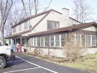

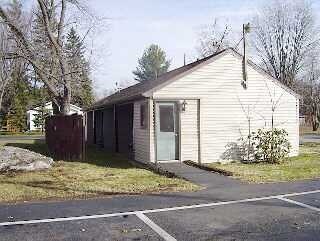
Property Detail
4958 Main St
Jamestown-Dunkirk, NY
ORIENTAL PARK DBA BEMUS INN; OLD APN: 063689 33-19-1
063689-333-013-0002-016-000
CHAUTAUQUA
Restaurantbuilding
New York
03 - MULTI
16.000
2025
0.52 AC
2025
New York West Area
036902
Other Market Areas
5,336 SF
NEARBY LISTINGS FOR SALE OR LEASE
-
-
View all Bemus Point listings for sale on LoopNet.com
DEMOGRAPHICS near 4958 Main St
1 mile
3 mile
5 mile
2025 Total Population
898
3,603
9,705
2030 Population
914
3,687
9,941
Pop Growth 2025-2030
+ 1.78%
+ 2.33%
+ 2.43%
Average Age
49
47
47
2025 Total Households
421
1,621
4,328
HH Growth 2025-2030
+ 1.19%
+ 2.04%
+ 2.33%
Median Household Inc
$80,258
$80,071
$72,638
Avg Household Size
2.10
2.20
2.20
2025 Avg HH Vehicles
2.00
2.00
2.00
Median Home Value
$205,000
$248,184
$219,342
Median Year Built
1956
1962
1960
Nearby Places
Map Layers
Map Styles
 Street
 Aerial
Layers
 Traffic
 Biking
Places
Listings with unknown addresses are not visible on the map
- Restaurants
- Banks
- Shops
- Fitness
- Groceries
Nearby Properties
Address
Land Use
TOTAL SIZE
Lot Size
Zoning
Address
Land Use
TOTAL SIZE
Lot Size
Zoning
2,128 SF
301 AC
02 - SINGL
Address
Land Use
TOTAL SIZE
Lot Size
Zoning
48,217 SF
2 AC
04 - FARM
Address
Land Use
TOTAL SIZE
Lot Size
Zoning
23,898 SF
16.30 AC
02 - SINGL
Address
Land Use
TOTAL SIZE
Lot Size
Zoning
71.40 AC
07 - MIXED
Address
Land Use
TOTAL SIZE
Lot Size
Zoning
19.40 AC
05 - COMME
Address
Land Use
TOTAL SIZE
Lot Size
Zoning
1,224 SF
51.50 AC
03 - MULTI
Address
Land Use
TOTAL SIZE
Lot Size
Zoning
1,248 SF
44.30 AC
04 - FARM
Address
Land Use
TOTAL SIZE
Lot Size
Zoning
Address
Land Use
TOTAL SIZE
Lot Size
Zoning
Address
Land Use
TOTAL SIZE
Lot Size
Zoning
3,799 SF
0.93 AC
02 - SINGL
Address
Land Use
TOTAL SIZE
Lot Size
Zoning
968 SF
1.30 AC
02 - SINGL
Address
Land Use
TOTAL SIZE
Lot Size
Zoning
10,824 SF
0.11 AC
05 - COMME
Address
Land Use
TOTAL SIZE
Lot Size
Zoning
8 AC
07 - MIXED
Address
Land Use
TOTAL SIZE
Lot Size
Zoning
21,171 SF
1.40 AC
03 - MULTI
Address
Land Use
TOTAL SIZE
Lot Size
Zoning
2,906 SF
2.20 AC
02 - SINGL
Address
Land Use
TOTAL SIZE
Lot Size
Zoning
4,140 SF
1.28 AC
02 - SINGL
Address
Land Use
TOTAL SIZE
Lot Size
Zoning
3,513 SF
15.50 AC
03 - MULTI
Address
Land Use
TOTAL SIZE
Lot Size
Zoning
1,905 SF
31 AC
02 - SINGL
Address
Land Use
TOTAL SIZE
Lot Size
Zoning
Address
Land Use
TOTAL SIZE
Lot Size
Zoning
2.40 AC
02 - SINGL
Address
Land Use
TOTAL SIZE
Lot Size
Zoning
4,860 SF
1.20 AC
05 - COMME
Address
Land Use
TOTAL SIZE
Lot Size
Zoning
792 SF
2.10 AC
03 - MULTI
Address
Land Use
TOTAL SIZE
Lot Size
Zoning
5,092 SF
2.30 AC
04 - FARM
Address
Land Use
TOTAL SIZE
Lot Size
Zoning
0.60 AC
02 - SINGL
Address
Land Use
TOTAL SIZE
Lot Size
Zoning
6,508 SF
3.30 AC
03 - MULTI
Address
Land Use
TOTAL SIZE
Lot Size
Zoning
8.30 AC
07 - MIXED
Address
Land Use
TOTAL SIZE
Lot Size
Zoning
6.40 AC
07 - MIXED
Address
Land Use
TOTAL SIZE
Lot Size
Zoning
3,554 SF
1.02 AC
02 - SINGL
Address
Land Use
TOTAL SIZE
Lot Size
Zoning
672 SF
1.21 AC
02 - SINGL
The World's #1 Commercial Real Estate Marketplace
Connect with us
© 2026 CoStar Group
The information above has been obtained from sources believed reliable. While we do not doubt its accuracy we have not verified it and make no guarantee, warranty or representation about it. It is your responsibility to independently confirm its accuracy and completeness. Any projections, opinions, assumptions, or estimates used are for example only and do not represent the current or future performance of the property. The value of this transaction to you depends on tax and other factors which should be evaluated by your tax, financial, and legal advisors. You and your advisors should conduct a careful, independent investigation of the property to determine to your satisfaction the suitability of the property for your needs.