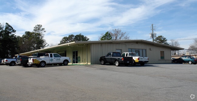
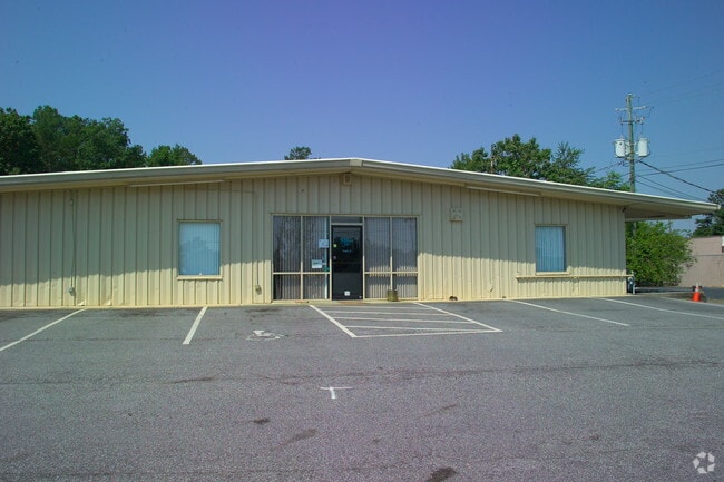
Property Record
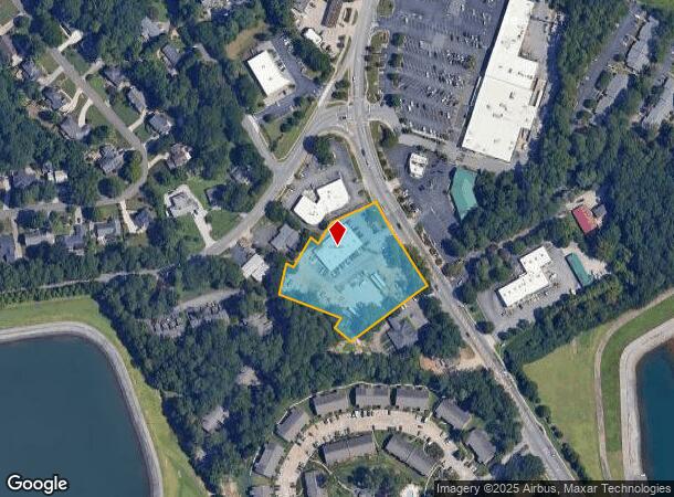
4958 Winters Chapel Rd, Atlanta, GA 30360
NEARBY LISTINGS FOR SALE OR LEASE
Property Detail
4958 Winters Chapel Rd
06-280-04-011
97 X 274 X 82 X 47 X 265 . . . . . . . . . . . .65AC 187 X 97 X 274 X 82 X 47 X 207 X 90 X 25 X 101 X 28 X 73 X 150 . . . . . . . . . . . .2.17AC 3-12-96
Warehouse
DeKalb
X
Georgia
13089C0010K
11
2025
2.17 AC
2025
Doraville
021305
Atlanta
6,955 SF
Atlanta-Sandy Springs-Roswell, GA
DEMOGRAPHICS near 4958 Winters Chapel Rd
1 Mile
3 Mile
5 Mile
2024 Total Population
13,034
82,071
245,655
2029 Population
13,270
83,117
249,246
Pop Growth 2024-2029
+ 1.81%
+ 1.27%
+ 1.46%
Average Age
35
38
37
2024 Total Households
4,779
32,326
97,010
HH Growth 2024-2029
+ 1.76%
+ 1.30%
+ 1.46%
Median Household Inc
$63,918
$68,182
$78,002
Avg Household Size
2.60
2.50
2.50
2024 Avg HH Vehicles
2.00
2.00
2.00
Median Home Value
$372,840
$426,855
$442,917
Median Year Built
1979
1982
1985
Nearby Places
Map Layers
Map Styles
 Street
 Aerial
- Restaurants
- Banks
- Shops
- Fitness
- Groceries
PUBLIC TRANSPORTATION
AIRPORT
Hartsfield - Jackson Atlanta International
DRIVE
WALK
Distance
Hartsfield - Jackson Atlanta International
41 min
28.1 mi
Nearby Properties
Address
Land Use
TOTAL SIZE
Lot Size
Zoning
Address
Land Use
TOTAL SIZE
Lot Size
Zoning
705,518 SF
39.09 AC
M
Address
Land Use
TOTAL SIZE
Lot Size
Zoning
103,056 SF
8.66 AC
OI
Address
Land Use
TOTAL SIZE
Lot Size
Zoning
524,000 SF
44.93 AC
RM
Address
Land Use
TOTAL SIZE
Lot Size
Zoning
545,074 SF
53.40 AC
RM8
Address
Land Use
TOTAL SIZE
Lot Size
Zoning
283,784 SF
30.88 AC
RM100
Address
Land Use
TOTAL SIZE
Lot Size
Zoning
204,376 SF
14.23 AC
X
Address
Land Use
TOTAL SIZE
Lot Size
Zoning
366,276 SF
11.54 AC
RM-HD
Address
Land Use
TOTAL SIZE
Lot Size
Zoning
286,481 SF
20.06 AC
M1
Address
Land Use
TOTAL SIZE
Lot Size
Zoning
358,622 SF
31.01 AC
RM13
Address
Land Use
TOTAL SIZE
Lot Size
Zoning
536,151 SF
30.35 AC
X
Address
Land Use
TOTAL SIZE
Lot Size
Zoning
303,866 SF
20.13 AC
RM
Address
Land Use
TOTAL SIZE
Lot Size
Zoning
424,948 SF
39.03 AC
RM13
Address
Land Use
TOTAL SIZE
Lot Size
Zoning
350,038 SF
25.05 AC
X
Address
Land Use
TOTAL SIZE
Lot Size
Zoning
211,544 SF
5.80 AC
RM75
Address
Land Use
TOTAL SIZE
Lot Size
Zoning
475,389 SF
5.37 AC
NX
Address
Land Use
TOTAL SIZE
Lot Size
Zoning
297,057 SF
25 AC
X
Address
Land Use
TOTAL SIZE
Lot Size
Zoning
141,164 SF
4.74 AC
Address
Land Use
TOTAL SIZE
Lot Size
Zoning
249,766 SF
25.34 AC
RM100
Address
Land Use
TOTAL SIZE
Lot Size
Zoning
229,415 SF
10.41 AC
RM-HD
Address
Land Use
TOTAL SIZE
Lot Size
Zoning
459,745 SF
50.72 AC
RM10
Address
Land Use
TOTAL SIZE
Lot Size
Zoning
439,205 SF
7.59 AC
C2
Address
Land Use
TOTAL SIZE
Lot Size
Zoning
420,576 SF
27.06 AC
M2
Address
Land Use
TOTAL SIZE
Lot Size
Zoning
220,940 SF
7.70 AC
RM75
Address
Land Use
TOTAL SIZE
Lot Size
Zoning
255,398 SF
12.45 AC
MUR
Address
Land Use
TOTAL SIZE
Lot Size
Zoning
291,110 SF
22.10 AC
X
Address
Land Use
TOTAL SIZE
Lot Size
Zoning
332,669 SF
27.29 AC
RM100
Address
Land Use
TOTAL SIZE
Lot Size
Zoning
224,504 SF
5.06 AC
OI
Address
Land Use
TOTAL SIZE
Lot Size
Zoning
408,205 SF
37.19 AC
RM100
Address
Land Use
TOTAL SIZE
Lot Size
Zoning
390,776 SF
43.96 AC
RM8
Address
Land Use
TOTAL SIZE
Lot Size
Zoning
205,850 SF
24.63 AC
RM10
The World's #1 Commercial Real Estate Marketplace
Connect with us
© 2025 CoStar Group
The information above has been obtained from sources believed reliable. While we do not doubt its accuracy we have not verified it and make no guarantee, warranty or representation about it. It is your responsibility to independently confirm its accuracy and completeness. Any projections, opinions, assumptions, or estimates used are for example only and do not represent the current or future performance of the property. The value of this transaction to you depends on tax and other factors which should be evaluated by your tax, financial, and legal advisors. You and your advisors should conduct a careful, independent investigation of the property to determine to your satisfaction the suitability of the property for your needs.