Property Record
4959 Ne Goodview Cir, Lees Summit, MO 64064
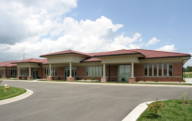

Property Detail
4959 Ne Goodview Cir
43-240-01-40-00-0-00-000
EXECUITVE LAKES BUSINESS CENTER 1ST PLAT---PT LOT 3 DAF: BEG NE COR SD LOT 3 TH N 87 DEG 38 MIN 00 SEC W 56 TH S 02 DEG 22 MIN 00 SEC W 21.50 TH N 87 DEG 38 MIN 00 SEC W 9.67 TH
Officecondo
Jackson
COMM
Missouri
B and X Area of moderate flood hazard, usually the area between the limits of the 100-year and 500-year floods.
3
2024
0.11 AC
2025
East Jackson County
018500
Kansas City
3,500 SF
Kansas City, MO-KS
NEARBY LISTINGS FOR SALE OR LEASE
DEMOGRAPHICS near 4959 Ne Goodview Cir
1 mile
3 mile
5 mile
2025 Total Population
4,478
30,724
105,757
2030 Population
4,552
30,868
105,737
Pop Growth 2025-2030
+ 1.65%
+ 0.47%
(0.02%)
Average Age
43
43
41
2025 Total Households
1,632
12,280
42,239
HH Growth 2025-2030
+ 1.59%
+ 0.48%
(0.03%)
Median Household Inc
$138,432
$92,461
$84,299
Avg Household Size
2.70
2.40
2.40
2025 Avg HH Vehicles
2.00
2.00
2.00
Median Home Value
$447,258
$321,336
$258,636
Median Year Built
1998
1993
1983
Nearby Places
Map Layers
Map Styles
 Street
 Aerial
Layers
 Traffic
 Biking
Places
Listings with unknown addresses are not visible on the map
- Restaurants
- Banks
- Shops
- Fitness
- Groceries
PUBLIC TRANSPORTATION
COMMUTER RAIL
Drive
Walk
Distance
13 min
7.7 mi
Drive
Walk
Distance
17 min
9.4 mi
AIRPORT
Kansas City International
Drive
Walk
Distance
Kansas City International
50 min
36.8 mi
SALE & LEASE HISTORY
LISTING DATE
SALE/LEASE

Oct 19, 2021
For Sale
Nearby Properties
Address
Land Use
TOTAL SIZE
Lot Size
Zoning
Address
Land Use
TOTAL SIZE
Lot Size
Zoning
158,369 SF
47.47 AC
Address
Land Use
TOTAL SIZE
Lot Size
Zoning
171,513 SF
18.37 AC
Address
Land Use
TOTAL SIZE
Lot Size
Zoning
96,348 SF
14.42 AC
Address
Land Use
TOTAL SIZE
Lot Size
Zoning
94,411 SF
4.99 AC
Address
Land Use
TOTAL SIZE
Lot Size
Zoning
39,638 SF
Address
Land Use
TOTAL SIZE
Lot Size
Zoning
179,962 SF
16.02 AC
Address
Land Use
TOTAL SIZE
Lot Size
Zoning
61,901 SF
15.11 AC
Address
Land Use
TOTAL SIZE
Lot Size
Zoning
36,396 SF
8.64 AC
Address
Land Use
TOTAL SIZE
Lot Size
Zoning
108,530 SF
17.95 AC
Address
Land Use
TOTAL SIZE
Lot Size
Zoning
128,393 SF
27.30 AC
Address
Land Use
TOTAL SIZE
Lot Size
Zoning
75,028 SF
16.11 AC
Address
Land Use
TOTAL SIZE
Lot Size
Zoning
129,570 SF
18.40 AC
Address
Land Use
TOTAL SIZE
Lot Size
Zoning
67,820 SF
11.94 AC
Address
Land Use
TOTAL SIZE
Lot Size
Zoning
20.97 AC
Address
Land Use
TOTAL SIZE
Lot Size
Zoning
113,696 SF
28.25 AC
Address
Land Use
TOTAL SIZE
Lot Size
Zoning
48,440 SF
21.49 AC
Address
Land Use
TOTAL SIZE
Lot Size
Zoning
148,044 SF
17.85 AC
Address
Land Use
TOTAL SIZE
Lot Size
Zoning
33,558 SF
2.74 AC
Address
Land Use
TOTAL SIZE
Lot Size
Zoning
Address
Land Use
TOTAL SIZE
Lot Size
Zoning
94,314 SF
20.02 AC
Address
Land Use
TOTAL SIZE
Lot Size
Zoning
87,599 SF
9.19 AC
Address
Land Use
TOTAL SIZE
Lot Size
Zoning
15,585 SF
5.39 AC
Address
Land Use
TOTAL SIZE
Lot Size
Zoning
135,346 SF
14.64 AC
Address
Land Use
TOTAL SIZE
Lot Size
Zoning
64,245 SF
10.05 AC
Address
Land Use
TOTAL SIZE
Lot Size
Zoning
48,464 SF
6.43 AC
Address
Land Use
TOTAL SIZE
Lot Size
Zoning
60,050 SF
5.34 AC
Address
Land Use
TOTAL SIZE
Lot Size
Zoning
32,400 SF
2.59 AC
Address
Land Use
TOTAL SIZE
Lot Size
Zoning
54,550 SF
5.87 AC
Address
Land Use
TOTAL SIZE
Lot Size
Zoning
36,627 SF
2.50 AC
Address
Land Use
TOTAL SIZE
Lot Size
Zoning
57,450 SF
4.37 AC
The World's #1 Commercial Real Estate Marketplace
Connect with us
© 2026 CoStar Group
The information above has been obtained from sources believed reliable. While we do not doubt its accuracy we have not verified it and make no guarantee, warranty or representation about it. It is your responsibility to independently confirm its accuracy and completeness. Any projections, opinions, assumptions, or estimates used are for example only and do not represent the current or future performance of the property. The value of this transaction to you depends on tax and other factors which should be evaluated by your tax, financial, and legal advisors. You and your advisors should conduct a careful, independent investigation of the property to determine to your satisfaction the suitability of the property for your needs.