Property Record
496 N Eatherton Rd, Chesterfield, MO 63005
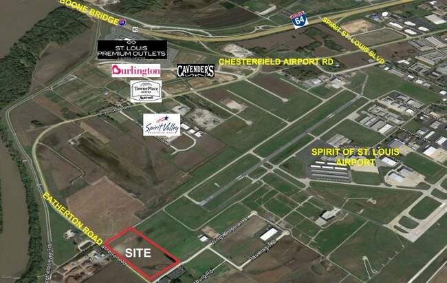

This Property Is For Sale
Property Detail
496 N Eatherton Rd
St. Louis, MO-IL
PRECISION PLAZA LOT 3
17W-11-0022
ST. LOUIS
Farms
Missouri
NU
3
2024
10.32 AC
2025
Chesterfield/Hwy-40
221629
St. Louis
NEARBY LISTINGS FOR SALE OR LEASE
-
-
-
Long Road Crossing Dr & N Trade Center
Chesterfield, MO 63005
$464,286 - $12,869,337
0.82 - 10.86 AC Lot
Land
-
-
-
-
View all Chesterfield listings for sale on LoopNet.com
DEMOGRAPHICS near 496 N Eatherton Rd
1 mile
3 mile
5 mile
2025 Total Population
51
4,900
36,260
2030 Population
53
4,903
36,888
Pop Growth 2025-2030
+ 3.92%
+ 0.06%
+ 1.73%
Average Age
38
41
42
2025 Total Households
16
1,543
12,717
HH Growth 2025-2030
0.00%
+ 0.06%
+ 1.97%
Median Household Inc
$276,923
$243,133
$162,063
Avg Household Size
3.40
3.10
2.80
2025 Avg HH Vehicles
3.00
3.00
2.00
Median Home Value
$799,999
$817,412
$537,734
Median Year Built
2006
1995
1994
Nearby Places
Map Layers
Map Styles
 Street
 Aerial
Layers
 Traffic
 Biking
Places
Listings with unknown addresses are not visible on the map
- Restaurants
- Banks
- Shops
- Fitness
- Groceries
PUBLIC TRANSPORTATION
AIRPORT
St Louis Lambert International
Drive
Walk
Distance
St Louis Lambert International
39 min
27.0 mi
Freight Ports
Tulsa Port of Inola
Drive
Walk
Distance
Tulsa Port of Inola
408 min
366.2 mi
Nearby Properties
Address
Land Use
TOTAL SIZE
Lot Size
Zoning
Address
Land Use
TOTAL SIZE
Lot Size
Zoning
Address
Land Use
TOTAL SIZE
Lot Size
Zoning
351,496 SF
31.73 AC
NU
Address
Land Use
TOTAL SIZE
Lot Size
Zoning
75,360 SF
8.13 AC
Address
Land Use
TOTAL SIZE
Lot Size
Zoning
117,704 SF
9.27 AC
105PI
Address
Land Use
TOTAL SIZE
Lot Size
Zoning
290,011 SF
23.40 AC
Address
Land Use
TOTAL SIZE
Lot Size
Zoning
294.04 AC
Address
Land Use
TOTAL SIZE
Lot Size
Zoning
7,860 SF
223.24 AC
105M3
Address
Land Use
TOTAL SIZE
Lot Size
Zoning
84,818 SF
10.11 AC
105M3
Address
Land Use
TOTAL SIZE
Lot Size
Zoning
8.15 AC
105PI
Address
Land Use
TOTAL SIZE
Lot Size
Zoning
89,616 SF
9.07 AC
M3
Address
Land Use
TOTAL SIZE
Lot Size
Zoning
74,783 SF
14.31 AC
105M3
Address
Land Use
TOTAL SIZE
Lot Size
Zoning
148,519 SF
12.76 AC
FPM3
Address
Land Use
TOTAL SIZE
Lot Size
Zoning
10.71 AC
105NU
Address
Land Use
TOTAL SIZE
Lot Size
Zoning
163,924 SF
11.56 AC
105M3
Address
Land Use
TOTAL SIZE
Lot Size
Zoning
134,313 SF
11.65 AC
105M3
Address
Land Use
TOTAL SIZE
Lot Size
Zoning
78,976 SF
10.24 AC
105M3
Address
Land Use
TOTAL SIZE
Lot Size
Zoning
78,566 SF
6.13 AC
105PI
Address
Land Use
TOTAL SIZE
Lot Size
Zoning
60,655 SF
10.33 AC
FPNU
Address
Land Use
TOTAL SIZE
Lot Size
Zoning
7.12 AC
105PI
Address
Land Use
TOTAL SIZE
Lot Size
Zoning
58,733 SF
4 AC
105M3
Address
Land Use
TOTAL SIZE
Lot Size
Zoning
66,180 SF
7.40 AC
105M3
Address
Land Use
TOTAL SIZE
Lot Size
Zoning
67,146 SF
4.25 AC
105PI
Address
Land Use
TOTAL SIZE
Lot Size
Zoning
63,000 SF
6.32 AC
105M3
Address
Land Use
TOTAL SIZE
Lot Size
Zoning
116,239 SF
8.44 AC
105PI
Address
Land Use
TOTAL SIZE
Lot Size
Zoning
52,833 SF
4.99 AC
105M3
Address
Land Use
TOTAL SIZE
Lot Size
Zoning
64,669 SF
2.17 AC
Address
Land Use
TOTAL SIZE
Lot Size
Zoning
22.37 AC
NU
Address
Land Use
TOTAL SIZE
Lot Size
Zoning
129,270 SF
12.76 AC
Address
Land Use
TOTAL SIZE
Lot Size
Zoning
62,814 SF
4.60 AC
Address
Land Use
TOTAL SIZE
Lot Size
Zoning
47,198 SF
4.95 AC
105M3
The World's #1 Commercial Real Estate Marketplace
Connect with us
© 2026 CoStar Group
The information above has been obtained from sources believed reliable. While we do not doubt its accuracy we have not verified it and make no guarantee, warranty or representation about it. It is your responsibility to independently confirm its accuracy and completeness. Any projections, opinions, assumptions, or estimates used are for example only and do not represent the current or future performance of the property. The value of this transaction to you depends on tax and other factors which should be evaluated by your tax, financial, and legal advisors. You and your advisors should conduct a careful, independent investigation of the property to determine to your satisfaction the suitability of the property for your needs.