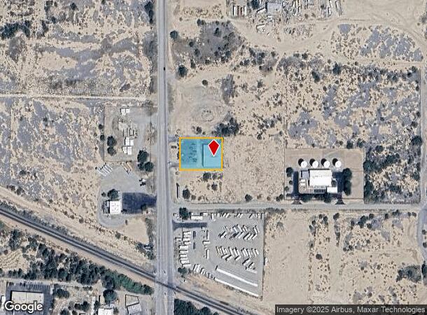
Property Record
496 N Ocotillo St, Benson, AZ 85602
NEARBY LISTINGS FOR SALE OR LEASE
Property Detail
496 N Ocotillo St
Gymhealthspa
A POR OF SWNE OF SEC 9 COM AT NW 4 OF SWNE THN S0DEG 1MIN W438 N 89MIN 58MIN E65 TO POB CONT N89DEG 58MIN E200 S0DEG 1MIN W150 S89DEG 58MIN W200 N0DEG 1MIN E150 TO POB SEC 9-17-20
X
Cochise
04003C1231G
Arizona
2024
0.69 AC
2025
Other Market Areas
000301
Sierra Vista-Douglas, AZ
7,808 SF
123-16-019B
DEMOGRAPHICS near 496 N Ocotillo St
1 Mile
3 Mile
5 Mile
2024 Total Population
2,489
7,185
7,946
2029 Population
2,587
7,437
8,220
Pop Growth 2024-2029
+ 3.94%
+ 3.51%
+ 3.45%
Average Age
48
49
49
2024 Total Households
1,208
3,344
3,674
HH Growth 2024-2029
+ 3.81%
+ 3.47%
+ 3.43%
Median Household Inc
$40,833
$51,868
$53,889
Avg Household Size
2.00
2.10
2.10
2024 Avg HH Vehicles
2.00
2.00
2.00
Median Home Value
$107,659
$148,007
$155,138
Median Year Built
1982
1988
1989
Nearby Places
Map Layers
Map Styles
 Street
 Aerial
- Restaurants
- Banks
- Shops
- Fitness
- Groceries
PUBLIC TRANSPORTATION
COMMUTER RAIL
Benson Amtrak (Sunset Limited - Amtrak, Texas Eagle - Amtrak)
DRIVE
WALK
Distance
Benson Amtrak (Sunset Limited - Amtrak, Texas Eagle - Amtrak)
1 min
16 min
0.8 mi
Freight Ports
Port of San Diego
DRIVE
WALK
Distance
Port of San Diego
482 min
454.9 mi
Nearby Properties
Address
Land Use
TOTAL SIZE
Lot Size
Zoning
Address
Land Use
TOTAL SIZE
Lot Size
Zoning
98,040 SF
10.11 AC
Address
Land Use
TOTAL SIZE
Lot Size
Zoning
92,124 SF
8.87 AC
Address
Land Use
TOTAL SIZE
Lot Size
Zoning
13,260 SF
7.08 AC
Address
Land Use
TOTAL SIZE
Lot Size
Zoning
20,000 SF
8 AC
Address
Land Use
TOTAL SIZE
Lot Size
Zoning
8,483 SF
2.66 AC
Address
Land Use
TOTAL SIZE
Lot Size
Zoning
7,395 SF
13.76 AC
Address
Land Use
TOTAL SIZE
Lot Size
Zoning
51,349 SF
6.58 AC
Address
Land Use
TOTAL SIZE
Lot Size
Zoning
19,143 SF
128.10 AC
Address
Land Use
TOTAL SIZE
Lot Size
Zoning
36,165 SF
2.20 AC
Address
Land Use
TOTAL SIZE
Lot Size
Zoning
42,726 SF
5.07 AC
Address
Land Use
TOTAL SIZE
Lot Size
Zoning
24,894 SF
20.05 AC
Address
Land Use
TOTAL SIZE
Lot Size
Zoning
22,060 SF
15.60 AC
Address
Land Use
TOTAL SIZE
Lot Size
Zoning
33,645 SF
3.21 AC
Address
Land Use
TOTAL SIZE
Lot Size
Zoning
41,677 SF
3.51 AC
Address
Land Use
TOTAL SIZE
Lot Size
Zoning
24,990 SF
3 AC
TR36
Address
Land Use
TOTAL SIZE
Lot Size
Zoning
28,583 SF
2.51 AC
Address
Land Use
TOTAL SIZE
Lot Size
Zoning
32,492 SF
2.35 AC
Address
Land Use
TOTAL SIZE
Lot Size
Zoning
12,733 SF
13.03 AC
Address
Land Use
TOTAL SIZE
Lot Size
Zoning
6,121 SF
11.71 AC
Address
Land Use
TOTAL SIZE
Lot Size
Zoning
0.96 AC
Address
Land Use
TOTAL SIZE
Lot Size
Zoning
12,000 SF
1.38 AC
Address
Land Use
TOTAL SIZE
Lot Size
Zoning
3,802 SF
0.60 AC
Address
Land Use
TOTAL SIZE
Lot Size
Zoning
3,551 SF
0.10 AC
LI
Address
Land Use
TOTAL SIZE
Lot Size
Zoning
2,601 SF
27.50 AC
Address
Land Use
TOTAL SIZE
Lot Size
Zoning
13,034 SF
1.48 AC
Address
Land Use
TOTAL SIZE
Lot Size
Zoning
8,907 SF
0.71 AC
Address
Land Use
TOTAL SIZE
Lot Size
Zoning
3,401 SF
1.33 AC
Address
Land Use
TOTAL SIZE
Lot Size
Zoning
10,120 SF
Address
Land Use
TOTAL SIZE
Lot Size
Zoning
21,796 SF
1.35 AC
Address
Land Use
TOTAL SIZE
Lot Size
Zoning
20,271 SF
2.20 AC
The World's #1 Commercial Real Estate Marketplace
Connect with us
© 2026 CoStar Group
The information above has been obtained from sources believed reliable. While we do not doubt its accuracy we have not verified it and make no guarantee, warranty or representation about it. It is your responsibility to independently confirm its accuracy and completeness. Any projections, opinions, assumptions, or estimates used are for example only and do not represent the current or future performance of the property. The value of this transaction to you depends on tax and other factors which should be evaluated by your tax, financial, and legal advisors. You and your advisors should conduct a careful, independent investigation of the property to determine to your satisfaction the suitability of the property for your needs.