Property Record
4963 Darrow Rd, Stow, OH 44224
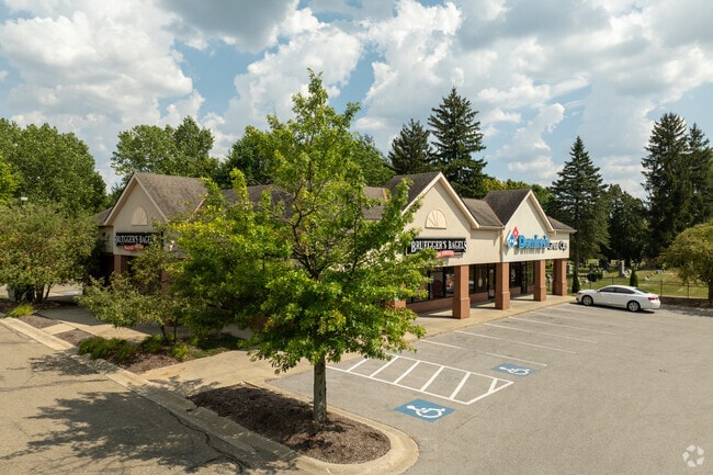


Property Detail
4963 Darrow Rd
Akron, OH
LOT 86 E OF DARROW RD 1.120AC
56-18618
Summit
Regionalshoppingcenterormallwithanchorstore
Ohio
2023
86
2025
1 AC
530605
Akron
5,280 SF
Cleveland
NEARBY LISTINGS FOR SALE OR LEASE
DEMOGRAPHICS near 4963 Darrow Rd
1 mile
3 mile
5 mile
2025 Total Population
6,680
42,971
103,583
2030 Population
6,764
43,028
103,856
Pop Growth 2025-2030
+ 1.26%
+ 0.13%
+ 0.26%
Average Age
42
42
42
2025 Total Households
2,809
17,345
42,986
HH Growth 2025-2030
+ 1.25%
+ 0.24%
+ 0.31%
Median Household Inc
$87,655
$106,576
$95,364
Avg Household Size
2.30
2.40
2.30
2025 Avg HH Vehicles
2.00
2.00
2.00
Median Home Value
$282,264
$294,200
$278,034
Median Year Built
1987
1978
1975
Nearby Places
Map Layers
Map Styles
 Street
 Aerial
Transit
 Traffic
 Biking
Places
Listings with unknown addresses are not visible on the map
- Restaurants
- Banks
- Shops
- Fitness
- Groceries
PUBLIC TRANSPORTATION
COMMUTER RAIL
Drive
Walk
Distance
15 min
7.7 mi
Drive
Walk
Distance
19 min
9.6 mi
AIRPORT
Akron-Canton Regional
Drive
Walk
Distance
Akron-Canton Regional
35 min
24.0 mi
Cleveland-Hopkins International
Drive
Walk
Distance
Cleveland-Hopkins International
50 min
34.3 mi
Nearby Properties
Address
Land Use
TOTAL SIZE
Lot Size
Zoning
Address
Land Use
TOTAL SIZE
Lot Size
Zoning
188,042 SF
45.24 AC
Address
Land Use
TOTAL SIZE
Lot Size
Zoning
Address
Land Use
TOTAL SIZE
Lot Size
Zoning
297,758 SF
23.28 AC
Address
Land Use
TOTAL SIZE
Lot Size
Zoning
114,568 SF
11.55 AC
Address
Land Use
TOTAL SIZE
Lot Size
Zoning
1,302,677 SF
121.15 AC
Address
Land Use
TOTAL SIZE
Lot Size
Zoning
15.41 AC
Address
Land Use
TOTAL SIZE
Lot Size
Zoning
118,740 SF
15.25 AC
Address
Land Use
TOTAL SIZE
Lot Size
Zoning
145,844 SF
9.80 AC
Address
Land Use
TOTAL SIZE
Lot Size
Zoning
60,022 SF
3.63 AC
Address
Land Use
TOTAL SIZE
Lot Size
Zoning
Address
Land Use
TOTAL SIZE
Lot Size
Zoning
84,500 SF
8.14 AC
Address
Land Use
TOTAL SIZE
Lot Size
Zoning
625,640 SF
45.31 AC
Address
Land Use
TOTAL SIZE
Lot Size
Zoning
17,731 SF
216.50 AC
Address
Land Use
TOTAL SIZE
Lot Size
Zoning
Address
Land Use
TOTAL SIZE
Lot Size
Zoning
157,827 SF
26.63 AC
Address
Land Use
TOTAL SIZE
Lot Size
Zoning
90,820 SF
23.72 AC
Address
Land Use
TOTAL SIZE
Lot Size
Zoning
165,600 SF
11.21 AC
Address
Land Use
TOTAL SIZE
Lot Size
Zoning
68,855 SF
32.57 AC
Address
Land Use
TOTAL SIZE
Lot Size
Zoning
136,220 SF
33 AC
Address
Land Use
TOTAL SIZE
Lot Size
Zoning
140,288 SF
19.51 AC
Address
Land Use
TOTAL SIZE
Lot Size
Zoning
26,231 SF
14.40 AC
Address
Land Use
TOTAL SIZE
Lot Size
Zoning
21.80 AC
Address
Land Use
TOTAL SIZE
Lot Size
Zoning
12.94 AC
Address
Land Use
TOTAL SIZE
Lot Size
Zoning
Address
Land Use
TOTAL SIZE
Lot Size
Zoning
31,442 SF
6.51 AC
Address
Land Use
TOTAL SIZE
Lot Size
Zoning
Address
Land Use
TOTAL SIZE
Lot Size
Zoning
619,128 SF
19.95 AC
Address
Land Use
TOTAL SIZE
Lot Size
Zoning
23,720 SF
17.58 AC
Address
Land Use
TOTAL SIZE
Lot Size
Zoning
6.52 AC
Address
Land Use
TOTAL SIZE
Lot Size
Zoning
7.20 AC
The World's #1 Commercial Real Estate Marketplace
Connect with us
© 2026 CoStar Group
The information above has been obtained from sources believed reliable. While we do not doubt its accuracy we have not verified it and make no guarantee, warranty or representation about it. It is your responsibility to independently confirm its accuracy and completeness. Any projections, opinions, assumptions, or estimates used are for example only and do not represent the current or future performance of the property. The value of this transaction to you depends on tax and other factors which should be evaluated by your tax, financial, and legal advisors. You and your advisors should conduct a careful, independent investigation of the property to determine to your satisfaction the suitability of the property for your needs.