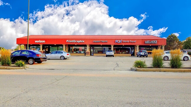
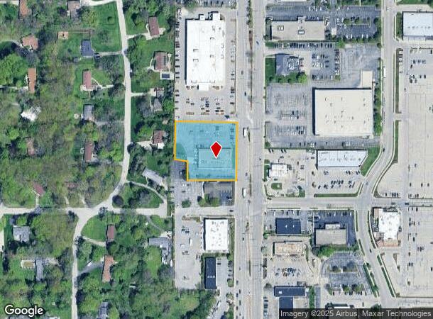
Property Record
4965 S 76Th St, Milwaukee, WI 53220
NEARBY LISTINGS FOR SALE OR LEASE
Property Detail
4965 S 76Th St
Milwaukee/Madison
4965-67-69-71-73-75 S 76 ST COM IN E LI 1850.75 FT S OF COR NE 28 6 21 TH W 260.02 F N 693.47 FT E 260 FT TH S TO BEG EX E 60 FT FOR ST ALSO A ON THE W CSM NO 4894 OUTLOT CSM NO 4895 OUTLOT 1 CSM NO 4896 OUTLOT 1 & CSM NO 4897 OUTLOT 1
Milwaukee-Waukesha, WI
Milwaukee
616-8974-003
Wisconsin
Commercialnec
2
2023
1.20 AC
2024
SW Outlying Milwaukee
120203
DEMOGRAPHICS near 4965 S 76Th St
1 mile
3 mile
5 mile
2024 Total Population
9,100
97,107
270,684
2029 Population
8,973
94,539
265,119
Pop Growth 2024-2029
(1.40%)
(2.64%)
(2.06%)
Average Age
43
42
41
2024 Total Households
4,264
42,907
113,390
HH Growth 2024-2029
(1.36%)
(2.70%)
(2.08%)
Median Household Inc
$69,602
$69,680
$67,459
Avg Household Size
2.10
2.20
2.30
2024 Avg HH Vehicles
2.00
2.00
2.00
Median Home Value
$246,987
$223,372
$216,455
Median Year Built
1971
1966
1963
Nearby Places
Map Layers
Map Styles
 Street
 Aerial
Transit
 Traffic
 Biking
Places
Listings with unknown addresses are not visible on the map
- Restaurants
- Banks
- Shops
- Fitness
- Groceries
PUBLIC TRANSPORTATION
COMMUTER RAIL
General Mitchell Intl. Airport Amtrak Station (Hiawatha Service - Amtrak)
Drive
Walk
Distance
General Mitchell Intl. Airport Amtrak Station (Hiawatha Service - Amtrak)
14 min
6.7 mi
AIRPORT
General Mitchell International
Drive
Walk
Distance
General Mitchell International
14 min
6.9 mi
Freight Ports
Port Milwaukee
Drive
Walk
Distance
Port Milwaukee
13 min
8.8 mi
SALE & LEASE HISTORY
LISTING DATE
SALE/LEASE

Sep 18, 2020
For Sale
Mar 28, 2023
For Lease
Nearby Properties
Address
Land Use
TOTAL SIZE
Lot Size
Zoning
Address
Land Use
TOTAL SIZE
Lot Size
Zoning
4.07 AC
Address
Land Use
TOTAL SIZE
Lot Size
Zoning
19.92 AC
Address
Land Use
TOTAL SIZE
Lot Size
Zoning
6.74 AC
Address
Land Use
TOTAL SIZE
Lot Size
Zoning
20.36 AC
Address
Land Use
TOTAL SIZE
Lot Size
Zoning
27.11 AC
Address
Land Use
TOTAL SIZE
Lot Size
Zoning
Address
Land Use
TOTAL SIZE
Lot Size
Zoning
17.46 AC
Address
Land Use
TOTAL SIZE
Lot Size
Zoning
8.70 AC
Address
Land Use
TOTAL SIZE
Lot Size
Zoning
23.09 AC
Address
Land Use
TOTAL SIZE
Lot Size
Zoning
5.74 AC
Address
Land Use
TOTAL SIZE
Lot Size
Zoning
18.79 AC
Address
Land Use
TOTAL SIZE
Lot Size
Zoning
17.47 AC
R2
Address
Land Use
TOTAL SIZE
Lot Size
Zoning
Address
Land Use
TOTAL SIZE
Lot Size
Zoning
262,150 SF
14.62 AC
PUDR5
Address
Land Use
TOTAL SIZE
Lot Size
Zoning
238,201 SF
17.96 AC
PUDR5
Address
Land Use
TOTAL SIZE
Lot Size
Zoning
228,912 SF
16.77 AC
Address
Land Use
TOTAL SIZE
Lot Size
Zoning
Address
Land Use
TOTAL SIZE
Lot Size
Zoning
20.61 AC
TL
Address
Land Use
TOTAL SIZE
Lot Size
Zoning
213,840 SF
13.95 AC
PUDR5
Address
Land Use
TOTAL SIZE
Lot Size
Zoning
213,964 SF
13.94 AC
PUDR5
Address
Land Use
TOTAL SIZE
Lot Size
Zoning
174,510 SF
7.37 AC
PD
Address
Land Use
TOTAL SIZE
Lot Size
Zoning
4.27 AC
Address
Land Use
TOTAL SIZE
Lot Size
Zoning
15.78 AC
Address
Land Use
TOTAL SIZE
Lot Size
Zoning
11.33 AC
Address
Land Use
TOTAL SIZE
Lot Size
Zoning
130,723 SF
12.94 AC
C2
Address
Land Use
TOTAL SIZE
Lot Size
Zoning
5.31 AC
Address
Land Use
TOTAL SIZE
Lot Size
Zoning
229,921 SF
8.07 AC
PUD
Address
Land Use
TOTAL SIZE
Lot Size
Zoning
Address
Land Use
TOTAL SIZE
Lot Size
Zoning
Address
Land Use
TOTAL SIZE
Lot Size
Zoning
The World's #1 Commercial Real Estate Marketplace
Connect with us
© 2026 CoStar Group
The information above has been obtained from sources believed reliable. While we do not doubt its accuracy we have not verified it and make no guarantee, warranty or representation about it. It is your responsibility to independently confirm its accuracy and completeness. Any projections, opinions, assumptions, or estimates used are for example only and do not represent the current or future performance of the property. The value of this transaction to you depends on tax and other factors which should be evaluated by your tax, financial, and legal advisors. You and your advisors should conduct a careful, independent investigation of the property to determine to your satisfaction the suitability of the property for your needs.