Property Record
49671 Highway 27, Davenport, FL 33897
NEARBY LISTINGS FOR SALE OR LEASE
-
-
View all Davenport listings for sale on LoopNet.com
Property Detail
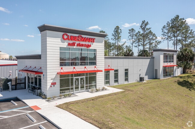
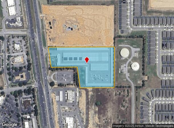
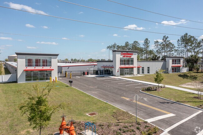
49671 Highway 27
26-25-13-000000-032040
Alameda Heights
Publicstorage
BEG 989.31 FT S OF N1/4 COR OF SEC RUN S 990.52 FT W 792.93 FT TO E R/W US HWY 27 RUN N 08 DEG 10 MIN 13 SEC W ALONG R/W 1000 FT E 908.44 FT TO POB LESS BEG 1979.83 FT S & 412.93 FT W OF N1/4 OF SEC RUN W 350 FT TO E R/W US HWY 27 RUN N 08 DEG 10 MIN
X
Polk
12105C0100G
Florida
2024
6.84 AC
2025
Polk County
012415
Tampa/St Petersburg
130,330 SF
Lakeland-Winter Haven, FL
DEMOGRAPHICS near 49671 Highway 27
1 Mile
3 Mile
5 Mile
2024 Total Population
11,353
48,060
100,676
2029 Population
14,068
59,677
124,360
Pop Growth 2024-2029
+ 23.91%
+ 24.17%
+ 23.52%
Average Age
36
39
38
2024 Total Households
3,785
18,080
37,423
HH Growth 2024-2029
+ 23.96%
+ 24.06%
+ 23.41%
Median Household Inc
$69,213
$59,906
$64,722
Avg Household Size
2.90
2.60
2.60
2024 Avg HH Vehicles
2.00
2.00
2.00
Median Home Value
$250,079
$247,186
$266,417
Median Year Built
2005
2005
2005
Nearby Places
Map Layers
Map Styles
 Street
 Aerial
- Restaurants
- Banks
- Shops
- Fitness
- Groceries
PUBLIC TRANSPORTATION
AIRPORT
Orlando International
DRIVE
WALK
Distance
Orlando International
45 min
30.2 mi
Freight Ports
Port of Tampa Bay
DRIVE
WALK
Distance
Port of Tampa Bay
76 min
62.8 mi
Nearby Properties
Address
Land Use
TOTAL SIZE
Lot Size
Zoning
Address
Land Use
TOTAL SIZE
Lot Size
Zoning
414,620 SF
16.64 AC
P-D
Address
Land Use
TOTAL SIZE
Lot Size
Zoning
480,142 SF
29.57 AC
OPD
Address
Land Use
TOTAL SIZE
Lot Size
Zoning
489,411 SF
19.04 AC
Address
Land Use
TOTAL SIZE
Lot Size
Zoning
380,530 SF
18.92 AC
RC
Address
Land Use
TOTAL SIZE
Lot Size
Zoning
364,023 SF
18.77 AC
OPD
Address
Land Use
TOTAL SIZE
Lot Size
Zoning
128,000 SF
19.60 AC
P-D
Address
Land Use
TOTAL SIZE
Lot Size
Zoning
381,117 SF
10.72 AC
Address
Land Use
TOTAL SIZE
Lot Size
Zoning
321,417 SF
23.19 AC
Address
Land Use
TOTAL SIZE
Lot Size
Zoning
479,776 SF
20.90 AC
Address
Land Use
TOTAL SIZE
Lot Size
Zoning
360,270 SF
16.97 AC
OPD
Address
Land Use
TOTAL SIZE
Lot Size
Zoning
353,423 SF
16.51 AC
PUD
Address
Land Use
TOTAL SIZE
Lot Size
Zoning
442,457 SF
28.76 AC
RC
Address
Land Use
TOTAL SIZE
Lot Size
Zoning
277,616 SF
19.03 AC
Address
Land Use
TOTAL SIZE
Lot Size
Zoning
272,106 SF
12.22 AC
Address
Land Use
TOTAL SIZE
Lot Size
Zoning
283,492 SF
11.97 AC
PUD
Address
Land Use
TOTAL SIZE
Lot Size
Zoning
196,553 SF
6.13 AC
Address
Land Use
TOTAL SIZE
Lot Size
Zoning
154,933 SF
20.94 AC
OPD
Address
Land Use
TOTAL SIZE
Lot Size
Zoning
168,045 SF
8.48 AC
OPUD
Address
Land Use
TOTAL SIZE
Lot Size
Zoning
24,465 SF
0.57 AC
P-D
Address
Land Use
TOTAL SIZE
Lot Size
Zoning
60,000 SF
10.79 AC
RC
Address
Land Use
TOTAL SIZE
Lot Size
Zoning
97,850 SF
3.02 AC
Address
Land Use
TOTAL SIZE
Lot Size
Zoning
236,248 SF
21.41 AC
PUD
Address
Land Use
TOTAL SIZE
Lot Size
Zoning
49,195 SF
11.61 AC
C1
Address
Land Use
TOTAL SIZE
Lot Size
Zoning
77,030 SF
11.78 AC
PUD
Address
Land Use
TOTAL SIZE
Lot Size
Zoning
95,708 SF
3.72 AC
PUD
Address
Land Use
TOTAL SIZE
Lot Size
Zoning
24,986 SF
2.72 AC
Address
Land Use
TOTAL SIZE
Lot Size
Zoning
92,829 SF
16.20 AC
Address
Land Use
TOTAL SIZE
Lot Size
Zoning
13,860 SF
4.23 AC
P-D
Address
Land Use
TOTAL SIZE
Lot Size
Zoning
88,789 SF
20.21 AC
OIN
Address
Land Use
TOTAL SIZE
Lot Size
Zoning
98,672 SF
1.93 AC
The World's #1 Commercial Real Estate Marketplace
Connect with us
© 2026 CoStar Group
The information above has been obtained from sources believed reliable. While we do not doubt its accuracy we have not verified it and make no guarantee, warranty or representation about it. It is your responsibility to independently confirm its accuracy and completeness. Any projections, opinions, assumptions, or estimates used are for example only and do not represent the current or future performance of the property. The value of this transaction to you depends on tax and other factors which should be evaluated by your tax, financial, and legal advisors. You and your advisors should conduct a careful, independent investigation of the property to determine to your satisfaction the suitability of the property for your needs.