Property Record
4968 E Rockton Rd, Roscoe, IL 61073

Property Detail
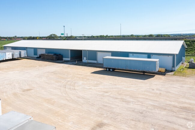
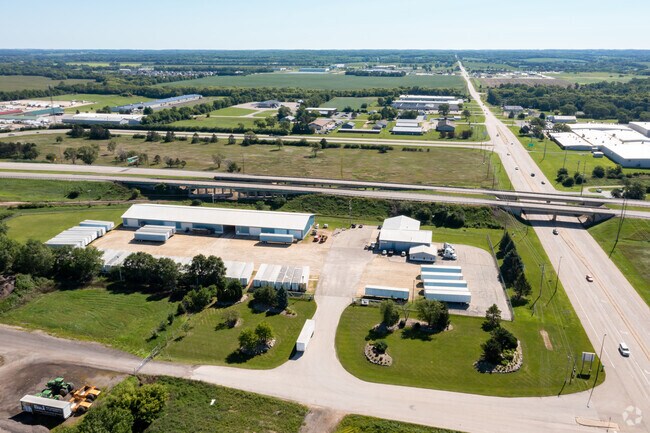
4968 E Rockton Rd
Rockford, IL
S PT E336.43FT S1/2 SE1/4 W OF RR R/W1135.60FT ON W LINE 140.44FT ON NLY LINE SEC: 17 TWP: 046 RANGE: 002 ACRES:6.68
04-17-400-014
WINNEBAGO
Industrialgeneral
Illinois
IG GENERAL
11
B and X Area of moderate flood hazard, usually the area between the limits of the 100-year and 500-year floods.
6.68 AC
2024
I-39 Cor/Winnebago Cy
2024
Chicago
004005
NEARBY LISTINGS FOR SALE OR LEASE
DEMOGRAPHICS near 4968 E Rockton Rd
1 mile
3 mile
5 mile
2025 Total Population
2,080
27,835
71,101
2030 Population
2,059
28,052
71,486
Pop Growth 2025-2030
(1.01%)
+ 0.78%
+ 0.54%
Average Age
37
40
39
2025 Total Households
713
10,600
26,804
HH Growth 2025-2030
(1.12%)
+ 0.80%
+ 0.57%
Median Household Inc
$125,204
$90,118
$75,766
Avg Household Size
2.90
2.60
2.50
2025 Avg HH Vehicles
2.00
2.00
2.00
Median Home Value
$226,804
$208,342
$198,607
Median Year Built
2000
1990
1975
Nearby Places
Map Layers
Map Styles
 Street
 Aerial
Layers
 Traffic
 Biking
Places
Listings with unknown addresses are not visible on the map
- Restaurants
- Banks
- Shops
- Fitness
- Groceries
PUBLIC TRANSPORTATION
AIRPORT
Chicago/Rockford International
Drive
Walk
Distance
Chicago/Rockford International
39 min
23.1 mi
Freight Ports
Port Milwaukee
Drive
Walk
Distance
Port Milwaukee
93 min
77.7 mi
SALE & LEASE HISTORY
LISTING DATE
SALE/LEASE

Aug 12, 2022
For Sale
Nearby Properties
Address
Land Use
TOTAL SIZE
Lot Size
Zoning
Address
Land Use
TOTAL SIZE
Lot Size
Zoning
16.81 AC
Address
Land Use
TOTAL SIZE
Lot Size
Zoning
33.53 AC
Address
Land Use
TOTAL SIZE
Lot Size
Zoning
121.46 AC
Address
Land Use
TOTAL SIZE
Lot Size
Zoning
47,561 SF
0.58 AC
Address
Land Use
TOTAL SIZE
Lot Size
Zoning
57,745 SF
9.57 AC
Address
Land Use
TOTAL SIZE
Lot Size
Zoning
23,715 SF
1.59 AC
Address
Land Use
TOTAL SIZE
Lot Size
Zoning
66.74 AC
Address
Land Use
TOTAL SIZE
Lot Size
Zoning
18,344 SF
21.54 AC
CT
Address
Land Use
TOTAL SIZE
Lot Size
Zoning
14,440 SF
1.53 AC
Address
Land Use
TOTAL SIZE
Lot Size
Zoning
8 AC
CN - COMM
Address
Land Use
TOTAL SIZE
Lot Size
Zoning
Address
Land Use
TOTAL SIZE
Lot Size
Zoning
12.78 AC
Address
Land Use
TOTAL SIZE
Lot Size
Zoning
29,488 SF
2.21 AC
Address
Land Use
TOTAL SIZE
Lot Size
Zoning
32,433 SF
0.31 AC
Address
Land Use
TOTAL SIZE
Lot Size
Zoning
18.34 AC
Address
Land Use
TOTAL SIZE
Lot Size
Zoning
31,920 SF
0.88 AC
Address
Land Use
TOTAL SIZE
Lot Size
Zoning
18,548 SF
1.51 AC
Address
Land Use
TOTAL SIZE
Lot Size
Zoning
34,903 SF
2.27 AC
Address
Land Use
TOTAL SIZE
Lot Size
Zoning
18.56 AC
Address
Land Use
TOTAL SIZE
Lot Size
Zoning
Address
Land Use
TOTAL SIZE
Lot Size
Zoning
17,327 SF
1.79 AC
Address
Land Use
TOTAL SIZE
Lot Size
Zoning
46,227 SF
2.35 AC
Address
Land Use
TOTAL SIZE
Lot Size
Zoning
8.61 AC
Address
Land Use
TOTAL SIZE
Lot Size
Zoning
82,123 SF
1 AC
Address
Land Use
TOTAL SIZE
Lot Size
Zoning
37,396 SF
0.78 AC
Address
Land Use
TOTAL SIZE
Lot Size
Zoning
218,074 SF
39.93 AC
IG GENERAL
Address
Land Use
TOTAL SIZE
Lot Size
Zoning
13.10 AC
Address
Land Use
TOTAL SIZE
Lot Size
Zoning
Address
Land Use
TOTAL SIZE
Lot Size
Zoning
52,026 SF
1.99 AC
Address
Land Use
TOTAL SIZE
Lot Size
Zoning
11.42 AC
The World's #1 Commercial Real Estate Marketplace
Connect with us
© 2026 CoStar Group
The information above has been obtained from sources believed reliable. While we do not doubt its accuracy we have not verified it and make no guarantee, warranty or representation about it. It is your responsibility to independently confirm its accuracy and completeness. Any projections, opinions, assumptions, or estimates used are for example only and do not represent the current or future performance of the property. The value of this transaction to you depends on tax and other factors which should be evaluated by your tax, financial, and legal advisors. You and your advisors should conduct a careful, independent investigation of the property to determine to your satisfaction the suitability of the property for your needs.