Property Record
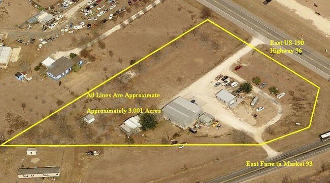
4971 E Us Highway 190, Temple, TX 76501

Property Detail
4971 E Us Highway 190
62682
A0014BC M MORENO, 412-1-1, 412-1-1-1, ACRES 3.0
Commercialnec
Bell
B and X Area of moderate flood hazard, usually the area between the limits of the 100-year and 500-year floods.
Texas
2025
3 AC
2025
Outlying Bell County
021400
Killeen/Temple/Fort Hood
5,324 SF
Killeen-Temple, TX
NEARBY LISTINGS FOR SALE OR LEASE
DEMOGRAPHICS near 4971 E Us Highway 190
1 mile
3 mile
5 mile
2025 Total Population
352
2,761
32,383
2030 Population
376
2,957
34,609
Pop Growth 2025-2030
+ 6.82%
+ 7.10%
+ 6.87%
Average Age
39
38
38
2025 Total Households
126
999
12,992
HH Growth 2025-2030
+ 7.14%
+ 7.41%
+ 7.11%
Median Household Inc
$79,375
$86,500
$66,924
Avg Household Size
2.70
2.70
2.40
2025 Avg HH Vehicles
2.00
2.00
2.00
Median Home Value
$389,285
$343,650
$253,783
Median Year Built
1991
2001
1995
Nearby Places
Map Layers
Map Styles
 Street
 Aerial
Layers
 Traffic
 Biking
Places
Listings with unknown addresses are not visible on the map
- Restaurants
- Banks
- Shops
- Fitness
- Groceries
PUBLIC TRANSPORTATION
COMMUTER RAIL
Temple (Texas Eagle - Amtrak)
Drive
Walk
Distance
Temple (Texas Eagle - Amtrak)
10 min
6.4 mi
AIRPORT
Killeen Municipal
Drive
Walk
Distance
Killeen Municipal
34 min
24.9 mi
Freight Ports
Port of Houston
Drive
Walk
Distance
Port of Houston
222 min
175.1 mi
Nearby Properties
Address
Land Use
TOTAL SIZE
Lot Size
Zoning
Address
Land Use
TOTAL SIZE
Lot Size
Zoning
1 SF
23.50 AC
Address
Land Use
TOTAL SIZE
Lot Size
Zoning
22,070 SF
5.02 AC
Address
Land Use
TOTAL SIZE
Lot Size
Zoning
28,464 SF
39.29 AC
Address
Land Use
TOTAL SIZE
Lot Size
Zoning
100 AC
Address
Land Use
TOTAL SIZE
Lot Size
Zoning
19,860 SF
13.16 AC
A
Address
Land Use
TOTAL SIZE
Lot Size
Zoning
16,589 SF
34.07 AC
Address
Land Use
TOTAL SIZE
Lot Size
Zoning
1,620 SF
195.58 AC
LI
Address
Land Use
TOTAL SIZE
Lot Size
Zoning
120.38 AC
Address
Land Use
TOTAL SIZE
Lot Size
Zoning
9,301 SF
1.08 AC
Address
Land Use
TOTAL SIZE
Lot Size
Zoning
1,373 SF
434.44 AC
Address
Land Use
TOTAL SIZE
Lot Size
Zoning
594.84 AC
Address
Land Use
TOTAL SIZE
Lot Size
Zoning
100 AC
Address
Land Use
TOTAL SIZE
Lot Size
Zoning
98.90 AC
Address
Land Use
TOTAL SIZE
Lot Size
Zoning
4,592 SF
437.88 AC
Address
Land Use
TOTAL SIZE
Lot Size
Zoning
208,550 SF
168.07 AC
Address
Land Use
TOTAL SIZE
Lot Size
Zoning
3,737 SF
100.51 AC
Address
Land Use
TOTAL SIZE
Lot Size
Zoning
785 SF
79.69 AC
Address
Land Use
TOTAL SIZE
Lot Size
Zoning
21.18 AC
Address
Land Use
TOTAL SIZE
Lot Size
Zoning
736 SF
794.84 AC
Address
Land Use
TOTAL SIZE
Lot Size
Zoning
61.84 AC
Address
Land Use
TOTAL SIZE
Lot Size
Zoning
244.44 AC
Address
Land Use
TOTAL SIZE
Lot Size
Zoning
16,600 SF
7.52 AC
Address
Land Use
TOTAL SIZE
Lot Size
Zoning
222.05 AC
Address
Land Use
TOTAL SIZE
Lot Size
Zoning
1,971 SF
547.95 AC
Address
Land Use
TOTAL SIZE
Lot Size
Zoning
1,170 SF
194.30 AC
Address
Land Use
TOTAL SIZE
Lot Size
Zoning
46.97 AC
Address
Land Use
TOTAL SIZE
Lot Size
Zoning
3,497 SF
21.84 AC
Address
Land Use
TOTAL SIZE
Lot Size
Zoning
896 SF
592 AC
Address
Land Use
TOTAL SIZE
Lot Size
Zoning
4,049 SF
19.98 AC
Address
Land Use
TOTAL SIZE
Lot Size
Zoning
2,065 SF
700.06 AC
The World's #1 Commercial Real Estate Marketplace
Connect with us
© 2026 CoStar Group
The information above has been obtained from sources believed reliable. While we do not doubt its accuracy we have not verified it and make no guarantee, warranty or representation about it. It is your responsibility to independently confirm its accuracy and completeness. Any projections, opinions, assumptions, or estimates used are for example only and do not represent the current or future performance of the property. The value of this transaction to you depends on tax and other factors which should be evaluated by your tax, financial, and legal advisors. You and your advisors should conduct a careful, independent investigation of the property to determine to your satisfaction the suitability of the property for your needs.