Property Record
4972 Cumming Hwy, Canton, GA 30115
This Property Is For Sale
NEARBY LISTINGS FOR SALE OR LEASE
Property Detail
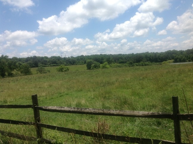
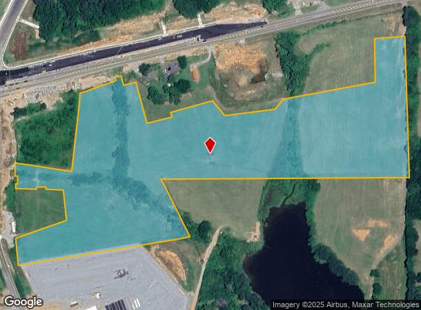
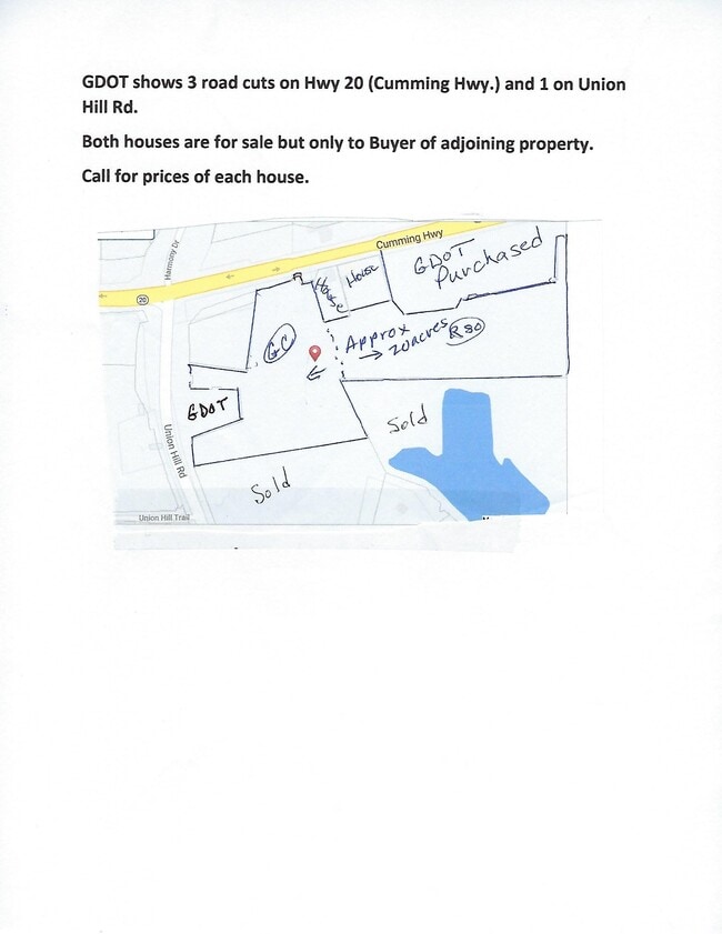
4972 Cumming Hwy
003N05-00000-097-00A-0000
LL 938 ET AL 3RD D
Taxexempt
Cherokee
X
Georgia
13057C0260E
20.15 AC
2025
Cherokee County
2025
Atlanta
090603
Atlanta-Sandy Springs-Roswell, GA
DEMOGRAPHICS near 4972 Cumming Hwy
1 Mile
3 Mile
5 Mile
2024 Total Population
1,664
11,655
51,438
2029 Population
1,915
13,269
58,952
Pop Growth 2024-2029
+ 15.08%
+ 13.85%
+ 14.61%
Average Age
41
41
39
2024 Total Households
569
3,958
17,523
HH Growth 2024-2029
+ 15.29%
+ 14.00%
+ 14.77%
Median Household Inc
$115,657
$112,800
$97,332
Avg Household Size
2.90
2.90
2.90
2024 Avg HH Vehicles
2.00
2.00
2.00
Median Home Value
$399,657
$421,306
$394,093
Median Year Built
2002
2002
2001
Nearby Places
Map Layers
Map Styles
 Street
 Aerial
- Restaurants
- Banks
- Shops
- Fitness
- Groceries
Nearby Properties
Address
Land Use
TOTAL SIZE
Lot Size
Zoning
Address
Land Use
TOTAL SIZE
Lot Size
Zoning
313,906 SF
28.96 AC
PD
Address
Land Use
TOTAL SIZE
Lot Size
Zoning
178,576 SF
13.74 AC
GC
Address
Land Use
TOTAL SIZE
Lot Size
Zoning
191,105 SF
12.37 AC
PD
Address
Land Use
TOTAL SIZE
Lot Size
Zoning
151,121 SF
33.37 AC
GC
Address
Land Use
TOTAL SIZE
Lot Size
Zoning
133,843 SF
31.69 AC
AG
Address
Land Use
TOTAL SIZE
Lot Size
Zoning
139,274 SF
12.34 AC
PD
Address
Land Use
TOTAL SIZE
Lot Size
Zoning
95,102 SF
19.53 AC
AG
Address
Land Use
TOTAL SIZE
Lot Size
Zoning
69,966 SF
22.62 AC
GC
Address
Land Use
TOTAL SIZE
Lot Size
Zoning
54.76 AC
PD
Address
Land Use
TOTAL SIZE
Lot Size
Zoning
86,913 SF
6.47 AC
PD
Address
Land Use
TOTAL SIZE
Lot Size
Zoning
81,240 SF
10.20 AC
GC
Address
Land Use
TOTAL SIZE
Lot Size
Zoning
39,657 SF
149.32 AC
AG
Address
Land Use
TOTAL SIZE
Lot Size
Zoning
85,610 SF
9.76 AC
GC
Address
Land Use
TOTAL SIZE
Lot Size
Zoning
246.49 AC
PUD
Address
Land Use
TOTAL SIZE
Lot Size
Zoning
52,895 SF
4.02 AC
GC
Address
Land Use
TOTAL SIZE
Lot Size
Zoning
960 SF
78.30 AC
R-15
Address
Land Use
TOTAL SIZE
Lot Size
Zoning
13,966 SF
1.56 AC
GC
Address
Land Use
TOTAL SIZE
Lot Size
Zoning
51,216 SF
11.31 AC
GC
Address
Land Use
TOTAL SIZE
Lot Size
Zoning
8,856 SF
0.97 AC
NC
Address
Land Use
TOTAL SIZE
Lot Size
Zoning
10,120 SF
1.25 AC
O-I
Address
Land Use
TOTAL SIZE
Lot Size
Zoning
1,462 SF
8.74 AC
NC
Address
Land Use
TOTAL SIZE
Lot Size
Zoning
22,729 SF
4.05 AC
AG
Address
Land Use
TOTAL SIZE
Lot Size
Zoning
6,042 SF
2.63 AC
GC
Address
Land Use
TOTAL SIZE
Lot Size
Zoning
134.91 AC
AG
Address
Land Use
TOTAL SIZE
Lot Size
Zoning
143.27 AC
AG
Address
Land Use
TOTAL SIZE
Lot Size
Zoning
2,946 SF
8.72 AC
NC
Address
Land Use
TOTAL SIZE
Lot Size
Zoning
6,080 SF
9.91 AC
GC
Address
Land Use
TOTAL SIZE
Lot Size
Zoning
12,160 SF
3.85 AC
PD
Address
Land Use
TOTAL SIZE
Lot Size
Zoning
30,557 SF
9.88 AC
R-80
Address
Land Use
TOTAL SIZE
Lot Size
Zoning
11,340 SF
1.96 AC
OI
The World's #1 Commercial Real Estate Marketplace
Connect with us
© 2025 CoStar Group
The information above has been obtained from sources believed reliable. While we do not doubt its accuracy we have not verified it and make no guarantee, warranty or representation about it. It is your responsibility to independently confirm its accuracy and completeness. Any projections, opinions, assumptions, or estimates used are for example only and do not represent the current or future performance of the property. The value of this transaction to you depends on tax and other factors which should be evaluated by your tax, financial, and legal advisors. You and your advisors should conduct a careful, independent investigation of the property to determine to your satisfaction the suitability of the property for your needs.