Property Record
4975 Bains Gap Rd, Anniston, AL 36205

NEARBY LISTINGS FOR SALE OR LEASE
-
-
View all Anniston listings for sale on LoopNet.com
Property Detail
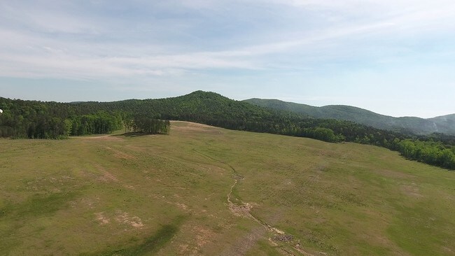
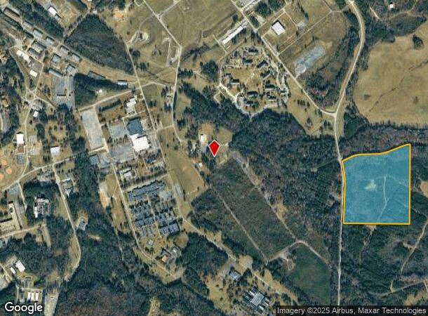
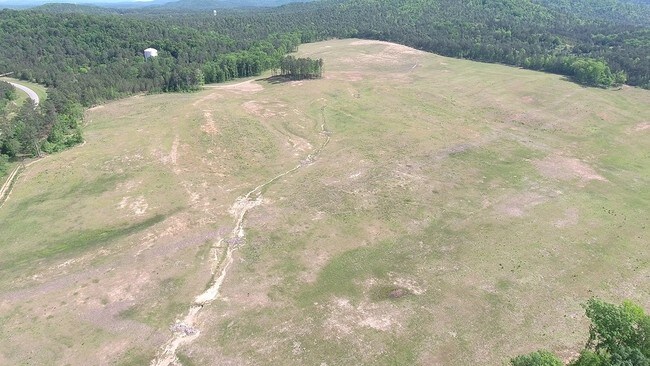
4975 Bains Gap Rd
18-06-23-2-002-001.000
SEC 23 TSP 15S R 8E BEG SE COR NW1/4 TH N 1473 SWLY 1319 S 1152 E 1129 TO POB ANNISTON AL
Timberlandforesttreesagricultural
Calhoun
A
Alabama
01015C0309E
37 AC
0
Gadsden/Anniston Area
2025
Other Market Areas
000700
Anniston-Oxford-Jacksonville, AL
DEMOGRAPHICS near 4975 Bains Gap Rd
1 Mile
3 Mile
5 Mile
2024 Total Population
246
3,406
28,132
2029 Population
259
3,415
27,876
Pop Growth 2024-2029
+ 5.28%
+ 0.26%
(0.91%)
Average Age
42
39
41
2024 Total Households
117
1,493
11,735
HH Growth 2024-2029
+ 6.84%
+ 0.40%
(0.90%)
Median Household Inc
$23,425
$31,593
$42,386
Avg Household Size
1.80
2.10
2.30
2024 Avg HH Vehicles
1.00
2.00
2.00
Median Home Value
$233,333
$154,651
$113,240
Median Year Built
2008
1975
1973
Nearby Places
Map Layers
Map Styles
 Street
 Aerial
- Restaurants
- Banks
- Shops
- Fitness
- Groceries
PUBLIC TRANSPORTATION
COMMUTER RAIL
Anniston Amtrak Station (Crescent - Amtrak)
DRIVE
WALK
Distance
Anniston Amtrak Station (Crescent - Amtrak)
15 min
7.4 mi
Freight Ports
Port of Panama City
DRIVE
WALK
Distance
Port of Panama City
373 min
299.5 mi
SALE & LEASE HISTORY
LISTING DATE
SALE/LEASE

Sep 24, 2016
For Sale
Dec 13, 2016
For Sale
Aug 11, 2017
For Sale
Nearby Properties
Address
Land Use
TOTAL SIZE
Lot Size
Zoning
Address
Land Use
TOTAL SIZE
Lot Size
Zoning
5,054 SF
11 AC
Address
Land Use
TOTAL SIZE
Lot Size
Zoning
18.55 AC
Address
Land Use
TOTAL SIZE
Lot Size
Zoning
138,119 SF
13.55 AC
Address
Land Use
TOTAL SIZE
Lot Size
Zoning
203,573 SF
17.16 AC
Address
Land Use
TOTAL SIZE
Lot Size
Zoning
133,349 SF
6.80 AC
Address
Land Use
TOTAL SIZE
Lot Size
Zoning
42,158 SF
5.20 AC
Address
Land Use
TOTAL SIZE
Lot Size
Zoning
71,060 SF
2.20 AC
Address
Land Use
TOTAL SIZE
Lot Size
Zoning
103,550 SF
9.15 AC
Address
Land Use
TOTAL SIZE
Lot Size
Zoning
127,717 SF
10 AC
Address
Land Use
TOTAL SIZE
Lot Size
Zoning
40,266 SF
16 AC
Address
Land Use
TOTAL SIZE
Lot Size
Zoning
Address
Land Use
TOTAL SIZE
Lot Size
Zoning
51,145 SF
2.49 AC
Address
Land Use
TOTAL SIZE
Lot Size
Zoning
14,208 SF
19 AC
Address
Land Use
TOTAL SIZE
Lot Size
Zoning
12,114 SF
7.10 AC
Address
Land Use
TOTAL SIZE
Lot Size
Zoning
27,338 SF
3.60 AC
Address
Land Use
TOTAL SIZE
Lot Size
Zoning
35,580 SF
3.48 AC
Address
Land Use
TOTAL SIZE
Lot Size
Zoning
121,812 SF
15.50 AC
Address
Land Use
TOTAL SIZE
Lot Size
Zoning
7,924 SF
9.50 AC
Address
Land Use
TOTAL SIZE
Lot Size
Zoning
61,526 SF
5.64 AC
Address
Land Use
TOTAL SIZE
Lot Size
Zoning
12,768 SF
5 AC
Address
Land Use
TOTAL SIZE
Lot Size
Zoning
Address
Land Use
TOTAL SIZE
Lot Size
Zoning
1,068 SF
7.63 AC
Address
Land Use
TOTAL SIZE
Lot Size
Zoning
15,518 SF
24 AC
Address
Land Use
TOTAL SIZE
Lot Size
Zoning
8,143 SF
4.80 AC
Address
Land Use
TOTAL SIZE
Lot Size
Zoning
56,920 SF
3 AC
Address
Land Use
TOTAL SIZE
Lot Size
Zoning
20,520 SF
2.39 AC
Address
Land Use
TOTAL SIZE
Lot Size
Zoning
19,137 SF
3.82 AC
Address
Land Use
TOTAL SIZE
Lot Size
Zoning
36,182 SF
3.24 AC
Address
Land Use
TOTAL SIZE
Lot Size
Zoning
10,602 SF
3.10 AC
Address
Land Use
TOTAL SIZE
Lot Size
Zoning
2,387 SF
4.51 AC
The World's #1 Commercial Real Estate Marketplace
Connect with us
© 2025 CoStar Group
The information above has been obtained from sources believed reliable. While we do not doubt its accuracy we have not verified it and make no guarantee, warranty or representation about it. It is your responsibility to independently confirm its accuracy and completeness. Any projections, opinions, assumptions, or estimates used are for example only and do not represent the current or future performance of the property. The value of this transaction to you depends on tax and other factors which should be evaluated by your tax, financial, and legal advisors. You and your advisors should conduct a careful, independent investigation of the property to determine to your satisfaction the suitability of the property for your needs.