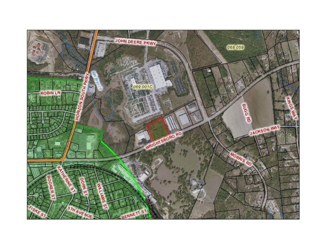
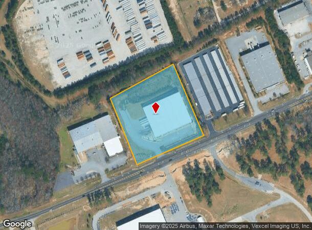
Property Record
4975 Wrightsboro Rd, Grovetown, GA 30813
NEARBY LISTINGS FOR SALE OR LEASE
Property Detail
4975 Wrightsboro Rd
Augusta-Richmond County, GA-SC
World Class Industries Inc & 1
069-001M
LOT D-3 5.03 ACS
Officebuilding
Columbia
X
Georgia
13245C0085G
d-3
2025
5.03 AC
2025
Outlying Columbia County
030505
Augusta/Richmond County
2,660 SF
DEMOGRAPHICS near 4975 Wrightsboro Rd
1 Mile
3 Mile
5 Mile
2024 Total Population
4,526
37,145
89,136
2029 Population
5,200
41,168
97,650
Pop Growth 2024-2029
+ 14.89%
+ 10.83%
+ 9.55%
Average Age
35
36
36
2024 Total Households
1,711
12,790
30,823
HH Growth 2024-2029
+ 14.14%
+ 10.47%
+ 8.96%
Median Household Inc
$63,814
$72,181
$75,811
Avg Household Size
2.70
2.80
2.80
2024 Avg HH Vehicles
2.00
2.00
2.00
Median Home Value
$193,012
$226,075
$225,840
Median Year Built
2005
2005
2003
Nearby Places
Map Layers
Map Styles
 Street
 Aerial
- Restaurants
- Banks
- Shops
- Fitness
- Groceries
PUBLIC TRANSPORTATION
AIRPORT
Augusta Regional at Bush Field
DRIVE
WALK
Distance
Augusta Regional at Bush Field
30 min
18.2 mi
Freight Ports
Georgia Ports - Savannah
DRIVE
WALK
Distance
Georgia Ports - Savannah
164 min
127.3 mi
SALE & LEASE HISTORY
LISTING DATE
SALE/LEASE

Sep 24, 2016
For Sale
Nearby Properties
Address
Land Use
TOTAL SIZE
Lot Size
Zoning
Address
Land Use
TOTAL SIZE
Lot Size
Zoning
26,790 SF
40.46 AC
Address
Land Use
TOTAL SIZE
Lot Size
Zoning
2,627 SF
23.57 AC
Address
Land Use
TOTAL SIZE
Lot Size
Zoning
118,470 SF
54 AC
Address
Land Use
TOTAL SIZE
Lot Size
Zoning
736 SF
14.23 AC
R-2;GENERA
Address
Land Use
TOTAL SIZE
Lot Size
Zoning
Address
Land Use
TOTAL SIZE
Lot Size
Zoning
191,892 SF
184.39 AC
Address
Land Use
TOTAL SIZE
Lot Size
Zoning
520,414 SF
40.73 AC
Address
Land Use
TOTAL SIZE
Lot Size
Zoning
1,120 SF
9.69 AC
Address
Land Use
TOTAL SIZE
Lot Size
Zoning
792 SF
213.93 AC
R-1;LOW DE
Address
Land Use
TOTAL SIZE
Lot Size
Zoning
Address
Land Use
TOTAL SIZE
Lot Size
Zoning
640 SF
157.81 AC
Address
Land Use
TOTAL SIZE
Lot Size
Zoning
176 SF
18.65 AC
Address
Land Use
TOTAL SIZE
Lot Size
Zoning
154,011 SF
18.45 AC
C-2;GEN CO
Address
Land Use
TOTAL SIZE
Lot Size
Zoning
Address
Land Use
TOTAL SIZE
Lot Size
Zoning
858 SF
2.70 AC
Address
Land Use
TOTAL SIZE
Lot Size
Zoning
Address
Land Use
TOTAL SIZE
Lot Size
Zoning
34,440 SF
10.75 AC
Address
Land Use
TOTAL SIZE
Lot Size
Zoning
3,936 SF
7.07 AC
Address
Land Use
TOTAL SIZE
Lot Size
Zoning
348 SF
2.59 AC
Address
Land Use
TOTAL SIZE
Lot Size
Zoning
Address
Land Use
TOTAL SIZE
Lot Size
Zoning
21,144 SF
5.35 AC
R-3;HI DEN
Address
Land Use
TOTAL SIZE
Lot Size
Zoning
85,234 SF
5.69 AC
R-3;HI DEN
Address
Land Use
TOTAL SIZE
Lot Size
Zoning
Address
Land Use
TOTAL SIZE
Lot Size
Zoning
10,649 SF
13.74 AC
Address
Land Use
TOTAL SIZE
Lot Size
Zoning
6,405 SF
18.70 AC
Address
Land Use
TOTAL SIZE
Lot Size
Zoning
30,000 SF
10.29 AC
Address
Land Use
TOTAL SIZE
Lot Size
Zoning
4,020 SF
12.63 AC
PUD
Address
Land Use
TOTAL SIZE
Lot Size
Zoning
40,816 SF
1.81 AC
Address
Land Use
TOTAL SIZE
Lot Size
Zoning
64,236 SF
7.24 AC
Address
Land Use
TOTAL SIZE
Lot Size
Zoning
50,320 SF
1.85 AC
The World's #1 Commercial Real Estate Marketplace
Connect with us
© 2025 CoStar Group
The information above has been obtained from sources believed reliable. While we do not doubt its accuracy we have not verified it and make no guarantee, warranty or representation about it. It is your responsibility to independently confirm its accuracy and completeness. Any projections, opinions, assumptions, or estimates used are for example only and do not represent the current or future performance of the property. The value of this transaction to you depends on tax and other factors which should be evaluated by your tax, financial, and legal advisors. You and your advisors should conduct a careful, independent investigation of the property to determine to your satisfaction the suitability of the property for your needs.