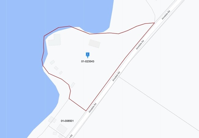
Property Record
49768 Airedele Rd, Ridge, MD 20680

Property Detail
49768 Airedele Rd
01-023543
1.25 ACRES
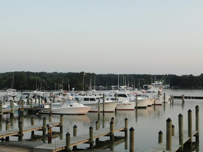
Commercialautotransportationstorage
Saint Marys
RPD
Maryland
AE The base floodplain where base flood elevations are provided. AE Zones are now used on new format FIRMs instead of A1-A30 Zones.
1.25 AC
2025
St Mary's County
2025
Washington, DC
876200
California-Lexington Park, MD
1,800 SF
NEARBY LISTINGS FOR SALE OR LEASE
-
-
View all Ridge listings for sale on LoopNet.com
DEMOGRAPHICS near 49768 Airedele Rd
1 mile
3 mile
5 mile
2025 Total Population
576
1,831
3,543
2030 Population
590
1,867
3,589
Pop Growth 2025-2030
+ 2.43%
+ 1.97%
+ 1.30%
Average Age
46
46
45
2025 Total Households
240
758
1,443
HH Growth 2025-2030
+ 2.50%
+ 2.11%
+ 1.46%
Median Household Inc
$104,107
$104,687
$107,296
Avg Household Size
2.30
2.30
2.40
2025 Avg HH Vehicles
2.00
2.00
2.00
Median Home Value
$437,500
$434,000
$428,779
Median Year Built
1959
1963
1970
Nearby Places
Map Layers
Map Styles
 Street
 Aerial
Layers
 Traffic
 Biking
Places
Listings with unknown addresses are not visible on the map
- Restaurants
- Banks
- Shops
- Fitness
- Groceries
Nearby Properties
Address
Land Use
TOTAL SIZE
Lot Size
Zoning
Address
Land Use
TOTAL SIZE
Lot Size
Zoning
4,112 SF
18.38 AC
VMX
Address
Land Use
TOTAL SIZE
Lot Size
Zoning
29,301 SF
13.93 AC
VMX
Address
Land Use
TOTAL SIZE
Lot Size
Zoning
3,592 SF
23.78 AC
CM
Address
Land Use
TOTAL SIZE
Lot Size
Zoning
4,505 SF
11.66 AC
RPD
Address
Land Use
TOTAL SIZE
Lot Size
Zoning
450 SF
4.40 AC
RPD
Address
Land Use
TOTAL SIZE
Lot Size
Zoning
2,208 SF
15.27 AC
VMX
Address
Land Use
TOTAL SIZE
Lot Size
Zoning
4,888 SF
5.77 AC
VMX
Address
Land Use
TOTAL SIZE
Lot Size
Zoning
486 SF
2.05 AC
CM
Address
Land Use
TOTAL SIZE
Lot Size
Zoning
9,350 SF
3.33 AC
VMX
Address
Land Use
TOTAL SIZE
Lot Size
Zoning
2,800 SF
7.68 AC
VMX
Address
Land Use
TOTAL SIZE
Lot Size
Zoning
3,711 SF
1.16 AC
CM
Address
Land Use
TOTAL SIZE
Lot Size
Zoning
2,762 SF
12 AC
RPD
Address
Land Use
TOTAL SIZE
Lot Size
Zoning
8,483 SF
1 AC
VMX
Address
Land Use
TOTAL SIZE
Lot Size
Zoning
2,880 SF
3.10 AC
CM
Address
Land Use
TOTAL SIZE
Lot Size
Zoning
1,688 SF
1.24 AC
RPD
Address
Land Use
TOTAL SIZE
Lot Size
Zoning
2,124 SF
15.70 AC
RPD
Address
Land Use
TOTAL SIZE
Lot Size
Zoning
3,024 SF
1 AC
RSC
Address
Land Use
TOTAL SIZE
Lot Size
Zoning
1,440 SF
3 AC
CM
Address
Land Use
TOTAL SIZE
Lot Size
Zoning
4,232 SF
1.45 AC
VMX
Address
Land Use
TOTAL SIZE
Lot Size
Zoning
8.66 AC
CM
Address
Land Use
TOTAL SIZE
Lot Size
Zoning
560 SF
4.95 AC
RPD
Address
Land Use
TOTAL SIZE
Lot Size
Zoning
5,850 SF
13.66 AC
RCL
Address
Land Use
TOTAL SIZE
Lot Size
Zoning
9,296 SF
1.24 AC
RPD
Address
Land Use
TOTAL SIZE
Lot Size
Zoning
1,216 SF
3.61 AC
VMX
Address
Land Use
TOTAL SIZE
Lot Size
Zoning
800 SF
4 AC
RPD
Address
Land Use
TOTAL SIZE
Lot Size
Zoning
6,756 SF
5.15 AC
VMX
Address
Land Use
TOTAL SIZE
Lot Size
Zoning
48.40 AC
RPD
Address
Land Use
TOTAL SIZE
Lot Size
Zoning
4,654 SF
1 AC
VMX
Address
Land Use
TOTAL SIZE
Lot Size
Zoning
2 AC
RPD
The World's #1 Commercial Real Estate Marketplace
Connect with us
© 2026 CoStar Group
The information above has been obtained from sources believed reliable. While we do not doubt its accuracy we have not verified it and make no guarantee, warranty or representation about it. It is your responsibility to independently confirm its accuracy and completeness. Any projections, opinions, assumptions, or estimates used are for example only and do not represent the current or future performance of the property. The value of this transaction to you depends on tax and other factors which should be evaluated by your tax, financial, and legal advisors. You and your advisors should conduct a careful, independent investigation of the property to determine to your satisfaction the suitability of the property for your needs.