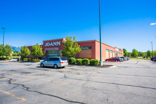
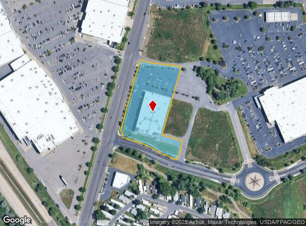
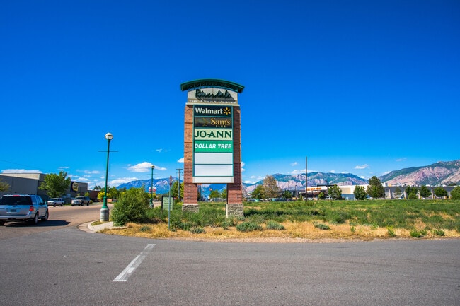
Property Record
4978 S 1050 W, Ogden, UT 84405
Current Lease Availabilities
NEARBY LISTINGS FOR SALE OR LEASE
Property Detail
4978 S 1050 W
Ogden-Clearfield, UT
ALL OF LOT 101, RIVERDALE JOANN COMMERCIAL SUBDIVISION, RIVERDALE CITY, WEBER COUNTY, UTAH.
07-819-0001
Weber
Wholesaleoutletdiscountstore
Utah
2025
101
2025
3 AC
210512
Davis/Weber Counties
36,048 SF
Salt Lake City
DEMOGRAPHICS near 4978 S 1050 W
1 Mile
3 Mile
5 Mile
2024 Total Population
8,632
79,760
208,918
2029 Population
9,285
84,521
222,723
Pop Growth 2024-2029
+ 7.56%
+ 5.97%
+ 6.61%
Average Age
36
36
35
2024 Total Households
3,253
27,753
71,253
HH Growth 2024-2029
+ 7.72%
+ 6.19%
+ 6.79%
Median Household Inc
$57,626
$69,083
$71,703
Avg Household Size
2.60
2.80
2.90
2024 Avg HH Vehicles
2.00
2.00
2.00
Median Home Value
$329,888
$325,916
$356,243
Median Year Built
1979
1977
1984
Nearby Places
Map Layers
Map Styles
 Street
 Aerial
- Restaurants
- Banks
- Shops
- Fitness
- Groceries
PUBLIC TRANSPORTATION
COMMUTER RAIL
Roy (FrontRunner North - Utah Transit Authority (UTA))
DRIVE
WALK
Distance
Roy (FrontRunner North - Utah Transit Authority (UTA))
8 min
3.3 mi
Ogden (FrontRunner North - Utah Transit Authority (UTA))
DRIVE
WALK
Distance
Ogden (FrontRunner North - Utah Transit Authority (UTA))
9 min
5.0 mi
AIRPORT
Salt Lake City International
DRIVE
WALK
Distance
Salt Lake City International
44 min
35.9 mi
Freight Ports
Port of Stockton
DRIVE
WALK
Distance
Port of Stockton
744 min
726.3 mi
Nearby Properties
Address
Land Use
TOTAL SIZE
Lot Size
Zoning
Address
Land Use
TOTAL SIZE
Lot Size
Zoning
790,525 SF
57.26 AC
Address
Land Use
TOTAL SIZE
Lot Size
Zoning
200,509 SF
12.75 AC
Address
Land Use
TOTAL SIZE
Lot Size
Zoning
35,219 SF
58.98 AC
Address
Land Use
TOTAL SIZE
Lot Size
Zoning
7,492 SF
8.96 AC
Address
Land Use
TOTAL SIZE
Lot Size
Zoning
83,038 SF
7.54 AC
Address
Land Use
TOTAL SIZE
Lot Size
Zoning
71,940 SF
11 AC
Address
Land Use
TOTAL SIZE
Lot Size
Zoning
98,660 SF
3.18 AC
Address
Land Use
TOTAL SIZE
Lot Size
Zoning
8,580 SF
6.40 AC
Address
Land Use
TOTAL SIZE
Lot Size
Zoning
115,094 SF
13.88 AC
Address
Land Use
TOTAL SIZE
Lot Size
Zoning
4,442 SF
7.19 AC
Address
Land Use
TOTAL SIZE
Lot Size
Zoning
225,497 SF
20.33 AC
Address
Land Use
TOTAL SIZE
Lot Size
Zoning
63,343 SF
16.43 AC
Address
Land Use
TOTAL SIZE
Lot Size
Zoning
255,596 SF
15.98 AC
Address
Land Use
TOTAL SIZE
Lot Size
Zoning
23,932 SF
5.53 AC
Address
Land Use
TOTAL SIZE
Lot Size
Zoning
10,440 SF
4.24 AC
Address
Land Use
TOTAL SIZE
Lot Size
Zoning
139,574 SF
9.30 AC
Address
Land Use
TOTAL SIZE
Lot Size
Zoning
96,690 SF
1.39 AC
Address
Land Use
TOTAL SIZE
Lot Size
Zoning
292,364 SF
24.15 AC
Address
Land Use
TOTAL SIZE
Lot Size
Zoning
17,220 SF
218.11 AC
Address
Land Use
TOTAL SIZE
Lot Size
Zoning
67,248 SF
13.28 AC
Address
Land Use
TOTAL SIZE
Lot Size
Zoning
48,290 SF
7.95 AC
Address
Land Use
TOTAL SIZE
Lot Size
Zoning
59,367 SF
5.90 AC
The World's #1 Commercial Real Estate Marketplace
Connect with us
© 2025 CoStar Group
The information above has been obtained from sources believed reliable. While we do not doubt its accuracy we have not verified it and make no guarantee, warranty or representation about it. It is your responsibility to independently confirm its accuracy and completeness. Any projections, opinions, assumptions, or estimates used are for example only and do not represent the current or future performance of the property. The value of this transaction to you depends on tax and other factors which should be evaluated by your tax, financial, and legal advisors. You and your advisors should conduct a careful, independent investigation of the property to determine to your satisfaction the suitability of the property for your needs.