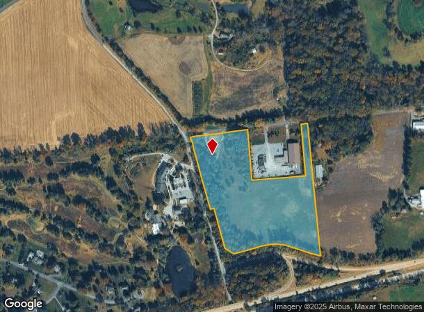
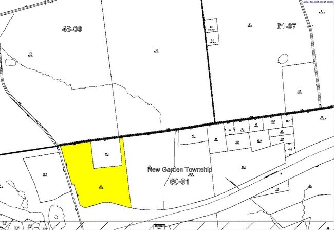
Property Record
498 Line Rd, Kennett Square, PA 19348

NEARBY LISTINGS FOR SALE OR LEASE
Property Detail
498 Line Rd
Philadelphia-Camden-Wilmington, PA-NJ-DE-MD
Second Haverford Corp
60-001-0041.0000
17.7 AC S & BARN
Miscellaneous
Chester
X
Pennsylvania
42029C0290G
1
2024
17.76 AC
2025
Outer Chester County
303501
Philadelphia
DEMOGRAPHICS near 498 Line Rd
1 Mile
3 Mile
5 Mile
2024 Total Population
558
15,697
44,662
2029 Population
556
16,277
46,491
Pop Growth 2024-2029
(0.36%)
+ 3.69%
+ 4.10%
Average Age
39
38
40
2024 Total Households
161
5,140
15,289
HH Growth 2024-2029
(0.62%)
+ 3.93%
+ 4.30%
Median Household Inc
$101,087
$103,626
$117,565
Avg Household Size
3.20
2.90
2.80
2024 Avg HH Vehicles
2.00
2.00
2.00
Median Home Value
$600,000
$408,999
$431,733
Median Year Built
1977
1983
1989
Nearby Places
Map Layers
Map Styles
 Street
 Aerial
- Restaurants
- Banks
- Shops
- Fitness
- Groceries
PUBLIC TRANSPORTATION
AIRPORT
Philadelphia International
DRIVE
WALK
Distance
Philadelphia International
49 min
30.8 mi
Freight Ports
Port of Wilmington, RI
DRIVE
WALK
Distance
Port of Wilmington, RI
36 min
19.9 mi
Nearby Properties
Address
Land Use
TOTAL SIZE
Lot Size
Zoning
Address
Land Use
TOTAL SIZE
Lot Size
Zoning
258,320 SF
42.68 AC
CI
Address
Land Use
TOTAL SIZE
Lot Size
Zoning
105,405 SF
17 AC
R1
Address
Land Use
TOTAL SIZE
Lot Size
Zoning
152,629 SF
152.30 AC
ES1
Address
Land Use
TOTAL SIZE
Lot Size
Zoning
99,228 SF
0.57 AC
C2
Address
Land Use
TOTAL SIZE
Lot Size
Zoning
451,182 SF
94.70 AC
BP
Address
Land Use
TOTAL SIZE
Lot Size
Zoning
114,126 SF
18.10 AC
CI
Address
Land Use
TOTAL SIZE
Lot Size
Zoning
69,351 SF
25 AC
UD
Address
Land Use
TOTAL SIZE
Lot Size
Zoning
66,899 SF
21.40 AC
RR
Address
Land Use
TOTAL SIZE
Lot Size
Zoning
200,337 SF
14 AC
CI
Address
Land Use
TOTAL SIZE
Lot Size
Zoning
70,197 SF
64.54 AC
ES1
Address
Land Use
TOTAL SIZE
Lot Size
Zoning
52,779 SF
14.50 AC
RR
Address
Land Use
TOTAL SIZE
Lot Size
Zoning
87,680 SF
11.40 AC
CI
Address
Land Use
TOTAL SIZE
Lot Size
Zoning
65,310 SF
5.07 AC
RB
Address
Land Use
TOTAL SIZE
Lot Size
Zoning
106,200 SF
10.40 AC
CI
Address
Land Use
TOTAL SIZE
Lot Size
Zoning
54,097 SF
3.80 AC
R3
Address
Land Use
TOTAL SIZE
Lot Size
Zoning
70,448 SF
11.40 AC
CI
Address
Land Use
TOTAL SIZE
Lot Size
Zoning
128,868 SF
1.25 AC
C2
Address
Land Use
TOTAL SIZE
Lot Size
Zoning
33,620 SF
1.13 AC
R2A
Address
Land Use
TOTAL SIZE
Lot Size
Zoning
66,184 SF
16 AC
ES1
Address
Land Use
TOTAL SIZE
Lot Size
Zoning
71,830 SF
22.40 AC
R2
Address
Land Use
TOTAL SIZE
Lot Size
Zoning
58,773 SF
11.04 AC
CI
Address
Land Use
TOTAL SIZE
Lot Size
Zoning
29,614 SF
28.29 AC
R1
Address
Land Use
TOTAL SIZE
Lot Size
Zoning
150,423 SF
44.22 AC
R1
Address
Land Use
TOTAL SIZE
Lot Size
Zoning
50,846 SF
10 AC
CI
Address
Land Use
TOTAL SIZE
Lot Size
Zoning
13,485 SF
229.49 AC
RB
Address
Land Use
TOTAL SIZE
Lot Size
Zoning
35,663 SF
101.80 AC
RB
Address
Land Use
TOTAL SIZE
Lot Size
Zoning
64,044 SF
69.21 AC
BP
Address
Land Use
TOTAL SIZE
Lot Size
Zoning
100,807 SF
83.99 AC
BP
Address
Land Use
TOTAL SIZE
Lot Size
Zoning
21,910 SF
8.75 AC
R1
Address
Land Use
TOTAL SIZE
Lot Size
Zoning
84,830 SF
10.66 AC
CI
The World's #1 Commercial Real Estate Marketplace
Connect with us
© 2026 CoStar Group
The information above has been obtained from sources believed reliable. While we do not doubt its accuracy we have not verified it and make no guarantee, warranty or representation about it. It is your responsibility to independently confirm its accuracy and completeness. Any projections, opinions, assumptions, or estimates used are for example only and do not represent the current or future performance of the property. The value of this transaction to you depends on tax and other factors which should be evaluated by your tax, financial, and legal advisors. You and your advisors should conduct a careful, independent investigation of the property to determine to your satisfaction the suitability of the property for your needs.