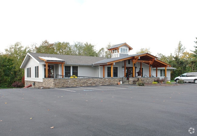
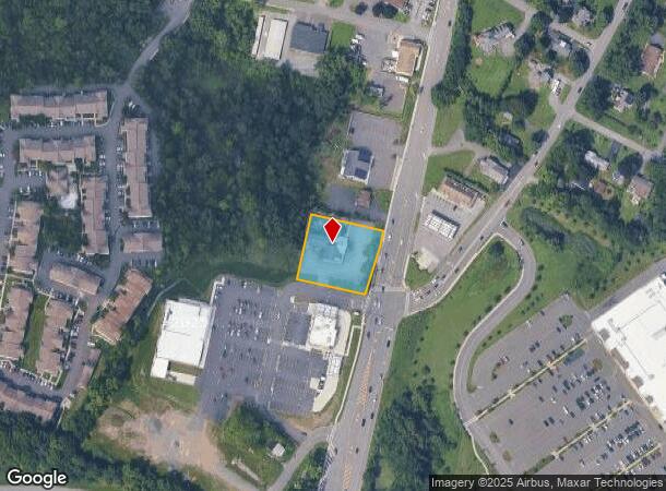
Property Record
498 N Greenbush Rd, Rensselaer, NY 12144

NEARBY LISTINGS FOR SALE OR LEASE
Property Detail
498 N Greenbush Rd
Albany-Schenectady-Troy, NY
BETTY JANE 23/100THS INT
3200-133-2-14
Rensselaer
Commercialnec
New York
ARE
14.000
36083C0237D
0.78 AC
2025
Outer Rensselaer County
2024
Albany/Schenectady/Troy
052301
DEMOGRAPHICS near 498 N Greenbush Rd
1 Mile
3 Mile
5 Mile
2024 Total Population
5,339
32,985
148,319
2029 Population
5,379
32,979
146,547
Pop Growth 2024-2029
+ 0.75%
(0.02%)
(1.19%)
Average Age
42
41
38
2024 Total Households
2,390
14,674
63,350
HH Growth 2024-2029
+ 0.71%
+ 0.09%
(1.24%)
Median Household Inc
$111,879
$72,864
$61,125
Avg Household Size
2.20
2.20
2.10
2024 Avg HH Vehicles
2.00
2.00
1.00
Median Home Value
$273,305
$243,437
$212,921
Median Year Built
1995
1974
1955
Nearby Places
- Restaurants
- Banks
- Shops
- Fitness
- Groceries
PUBLIC TRANSPORTATION
COMMUTER RAIL
DRIVE
WALK
Distance
9 min
3.8 mi
AIRPORT
Albany International
DRIVE
WALK
Distance
Albany International
22 min
11.8 mi
Freight Ports
Albany, NY Port
DRIVE
WALK
Distance
Albany, NY Port
12 min
6.4 mi
Nearby Properties
Address
Land Use
TOTAL SIZE
Lot Size
Zoning
Address
Land Use
TOTAL SIZE
Lot Size
Zoning
120,579 SF
49.20 AC
CI
Address
Land Use
TOTAL SIZE
Lot Size
Zoning
207.50 AC
CM
Address
Land Use
TOTAL SIZE
Lot Size
Zoning
177,030 SF
0.06 AC
C3
Address
Land Use
TOTAL SIZE
Lot Size
Zoning
296,914 SF
68.73 AC
PDD
Address
Land Use
TOTAL SIZE
Lot Size
Zoning
428,555 SF
1.20 AC
C3
Address
Land Use
TOTAL SIZE
Lot Size
Zoning
11,900 SF
28.60 AC
86
Address
Land Use
TOTAL SIZE
Lot Size
Zoning
179,713 SF
126.43 AC
OC
Address
Land Use
TOTAL SIZE
Lot Size
Zoning
316,634 SF
27.82 AC
OI
Address
Land Use
TOTAL SIZE
Lot Size
Zoning
470,768 SF
2.20 AC
C3
Address
Land Use
TOTAL SIZE
Lot Size
Zoning
194,018 SF
73.71 AC
R-B
Address
Land Use
TOTAL SIZE
Lot Size
Zoning
220,480 SF
8.40 AC
M1
Address
Land Use
TOTAL SIZE
Lot Size
Zoning
2.25 AC
Address
Land Use
TOTAL SIZE
Lot Size
Zoning
170,387 SF
0.54 AC
C3
Address
Land Use
TOTAL SIZE
Lot Size
Zoning
62,714 SF
8.74 AC
OI
Address
Land Use
TOTAL SIZE
Lot Size
Zoning
7.10 AC
CO
Address
Land Use
TOTAL SIZE
Lot Size
Zoning
45,782 SF
0.84 AC
C3
Address
Land Use
TOTAL SIZE
Lot Size
Zoning
85.40 AC
M1
Address
Land Use
TOTAL SIZE
Lot Size
Zoning
19,274 SF
24.80 AC
84
Address
Land Use
TOTAL SIZE
Lot Size
Zoning
99,223 SF
15.47 AC
R-B
Address
Land Use
TOTAL SIZE
Lot Size
Zoning
204,692 SF
30.97 AC
OC
Address
Land Use
TOTAL SIZE
Lot Size
Zoning
64,600 SF
13.16 AC
Address
Land Use
TOTAL SIZE
Lot Size
Zoning
90,174 SF
3.06 AC
R4
Address
Land Use
TOTAL SIZE
Lot Size
Zoning
131,937 SF
17.50 AC
R3A
Address
Land Use
TOTAL SIZE
Lot Size
Zoning
2,428 SF
23.10 AC
R3A
Address
Land Use
TOTAL SIZE
Lot Size
Zoning
102,845 SF
0.36 AC
C3
Address
Land Use
TOTAL SIZE
Lot Size
Zoning
62,039 SF
5.02 AC
O
Address
Land Use
TOTAL SIZE
Lot Size
Zoning
63,992 SF
20 AC
CM
Address
Land Use
TOTAL SIZE
Lot Size
Zoning
130,876 SF
26.03 AC
R-2
Address
Land Use
TOTAL SIZE
Lot Size
Zoning
34.12 AC
Address
Land Use
TOTAL SIZE
Lot Size
Zoning
47,284 SF
0.18 AC
C3
The World's #1 Commercial Real Estate Marketplace
Connect with us
© 2025 CoStar Group
The information above has been obtained from sources believed reliable. While we do not doubt its accuracy we have not verified it and make no guarantee, warranty or representation about it. It is your responsibility to independently confirm its accuracy and completeness. Any projections, opinions, assumptions, or estimates used are for example only and do not represent the current or future performance of the property. The value of this transaction to you depends on tax and other factors which should be evaluated by your tax, financial, and legal advisors. You and your advisors should conduct a careful, independent investigation of the property to determine to your satisfaction the suitability of the property for your needs.