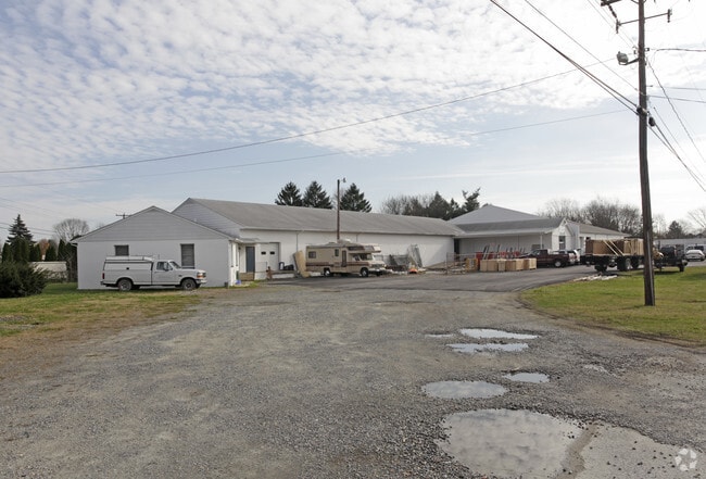
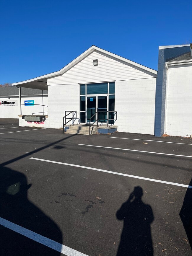
Property Record
499 Hatchery Rd, Dover, DE 19901

Property Detail
499 Hatchery Rd
2-00-05701-02-3300-000
E. SIDE OLD U.S. #13, 1.9564 A. 509 HATCHERY ROAD
Commercialnec
KENT
BG
Delaware
B and X Area of moderate flood hazard, usually the area between the limits of the 100-year and 500-year floods.
2.03 AC
2025
Kent County
2025
Philadelphia
041300
Dover, DE
20,975 SF
NEARBY LISTINGS FOR SALE OR LEASE
-
-
View all Dover listings for lease on LoopNet.com
DEMOGRAPHICS near 499 Hatchery Rd
1 mile
3 mile
5 mile
2025 Total Population
4,475
24,461
66,821
2030 Population
4,664
25,556
69,984
Pop Growth 2025-2030
+ 4.22%
+ 4.48%
+ 4.73%
Average Age
40
40
40
2025 Total Households
1,426
8,222
24,647
HH Growth 2025-2030
+ 4.35%
+ 4.32%
+ 4.63%
Median Household Inc
$78,007
$76,732
$68,733
Avg Household Size
2.50
2.50
2.50
2025 Avg HH Vehicles
2.00
2.00
2.00
Median Home Value
$294,599
$308,438
$312,100
Median Year Built
1995
1991
1992
Nearby Places
Map Layers
Map Styles
 Street
 Aerial
Layers
 Traffic
 Biking
Places
Listings with unknown addresses are not visible on the map
- Restaurants
- Banks
- Shops
- Fitness
- Groceries
SALE & LEASE HISTORY
LISTING DATE
SALE/LEASE

Feb 07, 2021
For Lease
Nearby Properties
Address
Land Use
TOTAL SIZE
Lot Size
Zoning
Address
Land Use
TOTAL SIZE
Lot Size
Zoning
231,470 SF
213.60 AC
IO
Address
Land Use
TOTAL SIZE
Lot Size
Zoning
247,145 SF
43.71 AC
CPO
Address
Land Use
TOTAL SIZE
Lot Size
Zoning
1,120 SF
181.50 AC
RC
Address
Land Use
TOTAL SIZE
Lot Size
Zoning
81,711 SF
93.70 AC
IO
Address
Land Use
TOTAL SIZE
Lot Size
Zoning
105,846 SF
15.79 AC
SC2
Address
Land Use
TOTAL SIZE
Lot Size
Zoning
567,080 SF
30.22 AC
IPM
Address
Land Use
TOTAL SIZE
Lot Size
Zoning
379,358 SF
67.30 AC
SC3
Address
Land Use
TOTAL SIZE
Lot Size
Zoning
55,456 SF
43.90 AC
IO
Address
Land Use
TOTAL SIZE
Lot Size
Zoning
44,560 SF
8.10 AC
IO
Address
Land Use
TOTAL SIZE
Lot Size
Zoning
210,400 SF
30 AC
IPM
Address
Land Use
TOTAL SIZE
Lot Size
Zoning
97,248 SF
9 AC
RG2
Address
Land Use
TOTAL SIZE
Lot Size
Zoning
69,228 SF
16.90 AC
RG5
Address
Land Use
TOTAL SIZE
Lot Size
Zoning
98,669 SF
12.40 AC
C4
Address
Land Use
TOTAL SIZE
Lot Size
Zoning
1,292 SF
65.25 AC
RMH
Address
Land Use
TOTAL SIZE
Lot Size
Zoning
56.90 AC
IO
Address
Land Use
TOTAL SIZE
Lot Size
Zoning
14,214 SF
319.30 AC
MULTI
Address
Land Use
TOTAL SIZE
Lot Size
Zoning
79,447 SF
3.18 AC
C4
Address
Land Use
TOTAL SIZE
Lot Size
Zoning
6,336 SF
52.20 AC
MHP
Address
Land Use
TOTAL SIZE
Lot Size
Zoning
199,272 SF
8.50 AC
RG1
Address
Land Use
TOTAL SIZE
Lot Size
Zoning
94,576 SF
10.74 AC
SC2
Address
Land Use
TOTAL SIZE
Lot Size
Zoning
137,247 SF
17 AC
C4
Address
Land Use
TOTAL SIZE
Lot Size
Zoning
132,449 SF
6 AC
RC
Address
Land Use
TOTAL SIZE
Lot Size
Zoning
112,320 SF
15.60 AC
RG2
Address
Land Use
TOTAL SIZE
Lot Size
Zoning
184,072 SF
22 AC
BG
Address
Land Use
TOTAL SIZE
Lot Size
Zoning
42,940 SF
7.85 AC
RM2
Address
Land Use
TOTAL SIZE
Lot Size
Zoning
136,933 SF
20.40 AC
C4
Address
Land Use
TOTAL SIZE
Lot Size
Zoning
47,245 SF
4.92 AC
C4
Address
Land Use
TOTAL SIZE
Lot Size
Zoning
76.70 AC
NA
Address
Land Use
TOTAL SIZE
Lot Size
Zoning
73,810 SF
17.90 AC
MULTI
Address
Land Use
TOTAL SIZE
Lot Size
Zoning
11,104 SF
7.56 AC
RG3
The World's #1 Commercial Real Estate Marketplace
Connect with us
© 2026 CoStar Group
The information above has been obtained from sources believed reliable. While we do not doubt its accuracy we have not verified it and make no guarantee, warranty or representation about it. It is your responsibility to independently confirm its accuracy and completeness. Any projections, opinions, assumptions, or estimates used are for example only and do not represent the current or future performance of the property. The value of this transaction to you depends on tax and other factors which should be evaluated by your tax, financial, and legal advisors. You and your advisors should conduct a careful, independent investigation of the property to determine to your satisfaction the suitability of the property for your needs.