Property Record
4991 Brooklake Rd Ne, Salem, OR 97305
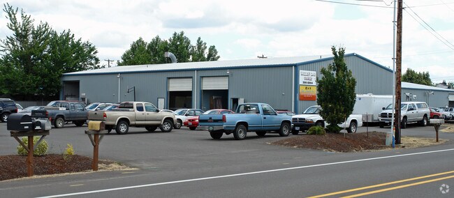

Property Detail
4991 Brooklake Rd Ne
543724
BROOKS BLOCK 4 LOT 1 ACRES .47
Officebuilding
MARION
CC
Oregon
B and X Area of moderate flood hazard, usually the area between the limits of the 100-year and 500-year floods.
1
2024
0.57 AC
2025
Marion County
002502
Portland
7,200 SF
Salem, OR
NEARBY LISTINGS FOR SALE OR LEASE
DEMOGRAPHICS near 4991 Brooklake Rd Ne
1 mile
3 mile
5 mile
2025 Total Population
830
4,395
50,656
2030 Population
822
4,369
51,208
Pop Growth 2025-2030
(0.96%)
(0.59%)
+ 1.09%
Average Age
41
41
39
2025 Total Households
279
1,468
17,756
HH Growth 2025-2030
(0.72%)
(0.48%)
+ 1.22%
Median Household Inc
$114,534
$102,746
$79,689
Avg Household Size
2.90
2.90
2.70
2025 Avg HH Vehicles
2.00
2.00
2.00
Median Home Value
$587,629
$546,635
$435,303
Median Year Built
1970
1976
1989
Nearby Places
Map Layers
Map Styles
 Street
 Aerial
Layers
 Traffic
 Biking
Places
Listings with unknown addresses are not visible on the map
- Restaurants
- Banks
- Shops
- Fitness
- Groceries
SALE & LEASE HISTORY
LISTING DATE
SALE/LEASE

Aug 14, 2023
For Lease
Apr 12, 2022
For Lease
Nearby Properties
Address
Land Use
TOTAL SIZE
Lot Size
Zoning
Address
Land Use
TOTAL SIZE
Lot Size
Zoning
Address
Land Use
TOTAL SIZE
Lot Size
Zoning
Address
Land Use
TOTAL SIZE
Lot Size
Zoning
213.36 AC
Address
Land Use
TOTAL SIZE
Lot Size
Zoning
16.15 AC
EFU
Address
Land Use
TOTAL SIZE
Lot Size
Zoning
51,286 SF
3.43 AC
P
Address
Land Use
TOTAL SIZE
Lot Size
Zoning
Address
Land Use
TOTAL SIZE
Lot Size
Zoning
Address
Land Use
TOTAL SIZE
Lot Size
Zoning
Address
Land Use
TOTAL SIZE
Lot Size
Zoning
Address
Land Use
TOTAL SIZE
Lot Size
Zoning
Address
Land Use
TOTAL SIZE
Lot Size
Zoning
Address
Land Use
TOTAL SIZE
Lot Size
Zoning
24,105 SF
6.27 AC
IBP
Address
Land Use
TOTAL SIZE
Lot Size
Zoning
34,603 SF
21.89 AC
ID
Address
Land Use
TOTAL SIZE
Lot Size
Zoning
5.34 AC
EFU
Address
Land Use
TOTAL SIZE
Lot Size
Zoning
10,496 SF
5.49 AC
ID
Address
Land Use
TOTAL SIZE
Lot Size
Zoning
5.62 AC
IUC
Address
Land Use
TOTAL SIZE
Lot Size
Zoning
15,270 SF
0.67 AC
P
Address
Land Use
TOTAL SIZE
Lot Size
Zoning
73.69 AC
Address
Land Use
TOTAL SIZE
Lot Size
Zoning
Address
Land Use
TOTAL SIZE
Lot Size
Zoning
41,586 SF
P
Address
Land Use
TOTAL SIZE
Lot Size
Zoning
16,540 SF
3.85 AC
IUC
Address
Land Use
TOTAL SIZE
Lot Size
Zoning
4,126 SF
0.84 AC
ID
Address
Land Use
TOTAL SIZE
Lot Size
Zoning
Address
Land Use
TOTAL SIZE
Lot Size
Zoning
10.02 AC
IG
Address
Land Use
TOTAL SIZE
Lot Size
Zoning
45,744 SF
2.63 AC
IUC
Address
Land Use
TOTAL SIZE
Lot Size
Zoning
18,740 SF
2.62 AC
IUC
Address
Land Use
TOTAL SIZE
Lot Size
Zoning
Address
Land Use
TOTAL SIZE
Lot Size
Zoning
44.92 AC
EFU; ID
Address
Land Use
TOTAL SIZE
Lot Size
Zoning
Address
Land Use
TOTAL SIZE
Lot Size
Zoning
The World's #1 Commercial Real Estate Marketplace
Connect with us
© 2026 CoStar Group
The information above has been obtained from sources believed reliable. While we do not doubt its accuracy we have not verified it and make no guarantee, warranty or representation about it. It is your responsibility to independently confirm its accuracy and completeness. Any projections, opinions, assumptions, or estimates used are for example only and do not represent the current or future performance of the property. The value of this transaction to you depends on tax and other factors which should be evaluated by your tax, financial, and legal advisors. You and your advisors should conduct a careful, independent investigation of the property to determine to your satisfaction the suitability of the property for your needs.