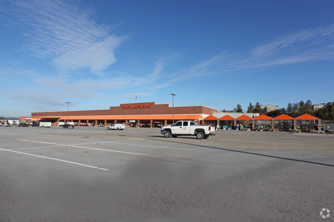
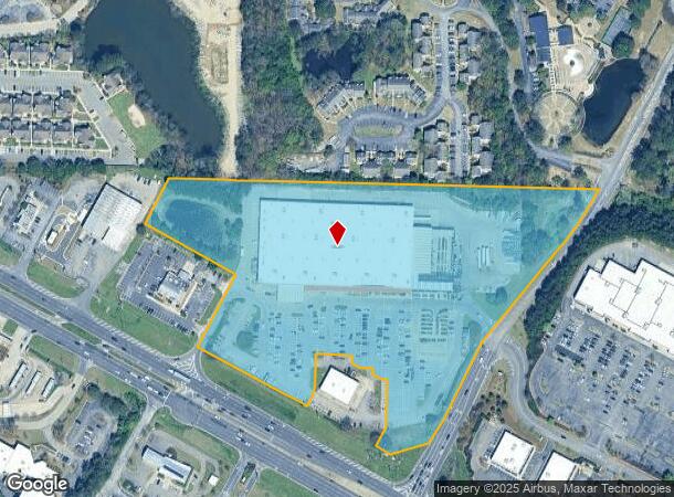
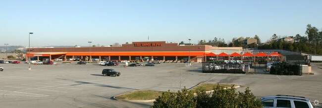
Property Record
4995 Highway 280, Hoover, AL 35242
NEARBY LISTINGS FOR SALE OR LEASE
Property Detail
4995 Highway 280
Birmingham-Hoover, AL
Inverness Site-34
02-7-36-0-001-020-000
LESS AND EXCEPT COM INT W ROW CAHABA BEACH RD & N ROW HWY 280 NW ALG HWY 280 49.43 TO POB NW ALG SD HWY 235.44 NE35.41 NLY30.61 N94.27 E105.11 S19.23 SE30.62 E36.5 S17.63 SE28.43 E18.24 S99.1 SW89.89 TO POB (AKA OUTPARCEL 34B MB43 PG59)
Commercialbuilding
Shelby
X
Alabama
01117C0087F
34
2024
13.76 AC
2024
Hwy 280/Shelby County
030212
Birmingham
110,079 SF
DEMOGRAPHICS near 4995 Highway 280
1 Mile
3 Mile
5 Mile
2024 Total Population
8,406
43,032
88,415
2029 Population
9,036
45,588
91,574
Pop Growth 2024-2029
+ 7.49%
+ 5.94%
+ 3.57%
Average Age
39
41
41
2024 Total Households
4,113
19,206
36,470
HH Growth 2024-2029
+ 7.54%
+ 5.66%
+ 3.52%
Median Household Inc
$74,829
$94,557
$107,169
Avg Household Size
2.00
2.20
2.40
2024 Avg HH Vehicles
2.00
2.00
2.00
Median Home Value
$342,713
$381,900
$416,308
Median Year Built
1991
1994
1992
Nearby Places
Map Layers
Map Styles
 Street
 Aerial
- Restaurants
- Banks
- Shops
- Fitness
- Groceries
PUBLIC TRANSPORTATION
AIRPORT
Birmingham-Shuttlesworth International
DRIVE
WALK
Distance
Birmingham-Shuttlesworth International
22 min
14.0 mi
Freight Ports
Port of Mobile
DRIVE
WALK
Distance
Port of Mobile
277 min
250.4 mi
Nearby Properties
Address
Land Use
TOTAL SIZE
Lot Size
Zoning
Address
Land Use
TOTAL SIZE
Lot Size
Zoning
200,418 SF
6.50 AC
C1
Address
Land Use
TOTAL SIZE
Lot Size
Zoning
15,013 SF
79.12 AC
Address
Land Use
TOTAL SIZE
Lot Size
Zoning
212,615 SF
19.66 AC
B-2
Address
Land Use
TOTAL SIZE
Lot Size
Zoning
500,279 SF
52.57 AC
B2
Address
Land Use
TOTAL SIZE
Lot Size
Zoning
140,853 SF
27 AC
B-2
Address
Land Use
TOTAL SIZE
Lot Size
Zoning
7,280 SF
35 AC
Address
Land Use
TOTAL SIZE
Lot Size
Zoning
347,636 SF
136.83 AC
Address
Land Use
TOTAL SIZE
Lot Size
Zoning
153,413 SF
6.35 AC
C1
Address
Land Use
TOTAL SIZE
Lot Size
Zoning
6 AC
C-1
Address
Land Use
TOTAL SIZE
Lot Size
Zoning
169,501 SF
18 AC
E-2
Address
Land Use
TOTAL SIZE
Lot Size
Zoning
4,674 SF
28.10 AC
Address
Land Use
TOTAL SIZE
Lot Size
Zoning
136,498 SF
11 AC
C1
Address
Land Use
TOTAL SIZE
Lot Size
Zoning
37,950 SF
26.50 AC
Address
Land Use
TOTAL SIZE
Lot Size
Zoning
30,967 SF
17.39 AC
Address
Land Use
TOTAL SIZE
Lot Size
Zoning
132,501 SF
50.39 AC
Address
Land Use
TOTAL SIZE
Lot Size
Zoning
235,082 SF
26.10 AC
C1
Address
Land Use
TOTAL SIZE
Lot Size
Zoning
102,373 SF
12.33 AC
R1-E
Address
Land Use
TOTAL SIZE
Lot Size
Zoning
4,335 SF
26.43 AC
Address
Land Use
TOTAL SIZE
Lot Size
Zoning
344,434 SF
15.52 AC
R4
Address
Land Use
TOTAL SIZE
Lot Size
Zoning
239,213 SF
17 AC
C1
Address
Land Use
TOTAL SIZE
Lot Size
Zoning
64,375 SF
8.99 AC
Address
Land Use
TOTAL SIZE
Lot Size
Zoning
11,058 SF
24.33 AC
Address
Land Use
TOTAL SIZE
Lot Size
Zoning
111,045 SF
25.72 AC
Address
Land Use
TOTAL SIZE
Lot Size
Zoning
321,157 SF
33 AC
C
Address
Land Use
TOTAL SIZE
Lot Size
Zoning
59,454 SF
4.21 AC
C1
Address
Land Use
TOTAL SIZE
Lot Size
Zoning
11,492 SF
21.30 AC
Address
Land Use
TOTAL SIZE
Lot Size
Zoning
125,165 SF
8.07 AC
CP
Address
Land Use
TOTAL SIZE
Lot Size
Zoning
89,134 SF
6.50 AC
C-1
Address
Land Use
TOTAL SIZE
Lot Size
Zoning
2,404 SF
17.42 AC
The World's #1 Commercial Real Estate Marketplace
Connect with us
© 2025 CoStar Group
The information above has been obtained from sources believed reliable. While we do not doubt its accuracy we have not verified it and make no guarantee, warranty or representation about it. It is your responsibility to independently confirm its accuracy and completeness. Any projections, opinions, assumptions, or estimates used are for example only and do not represent the current or future performance of the property. The value of this transaction to you depends on tax and other factors which should be evaluated by your tax, financial, and legal advisors. You and your advisors should conduct a careful, independent investigation of the property to determine to your satisfaction the suitability of the property for your needs.