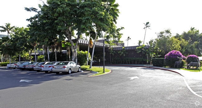
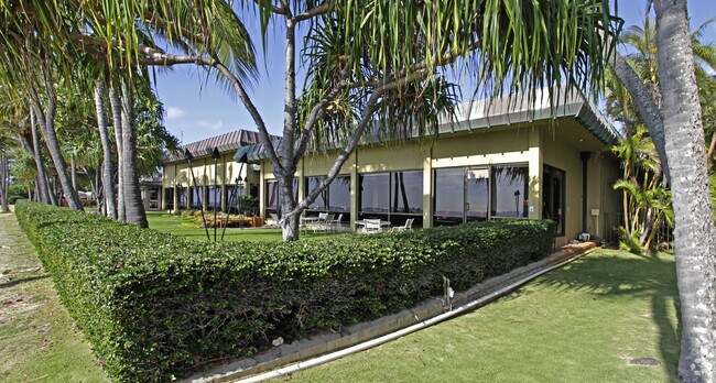
Property Record
4997 Kahala Ave, Honolulu, HI 96816

NEARBY LISTINGS FOR SALE OR LEASE
-
-
View all Honolulu listings for sale on LoopNet.com
Property Detail
4997 Kahala Ave
1-3-5-023-038-0000
Waialae Country Club
Culturalhistorical
Honolulu
VE
Hawaii
15003C0369H
14
2024
2.15 AC
2025
East Oahu
000500
Hawaii
32,964 SF
Urban Honolulu, HI
DEMOGRAPHICS near 4997 Kahala Ave
1 Mile
3 Mile
5 Mile
2024 Total Population
9,761
83,503
221,621
2029 Population
9,732
81,908
220,722
Pop Growth 2024-2029
(0.30%)
(1.91%)
(0.41%)
Average Age
49
45
46
2024 Total Households
3,389
30,746
94,793
HH Growth 2024-2029
(0.94%)
(2.32%)
(0.52%)
Median Household Inc
$138,316
$104,424
$80,782
Avg Household Size
2.60
2.50
2.20
2024 Avg HH Vehicles
2.00
2.00
1.00
Median Home Value
$1,075,525
$1,040,122
$875,058
Median Year Built
1969
1965
1971
Nearby Places
Map Layers
Map Styles
 Street
 Aerial
- Restaurants
- Banks
- Shops
- Fitness
- Groceries
PUBLIC TRANSPORTATION
AIRPORT
Daniel K Inouye International
DRIVE
WALK
Distance
Daniel K Inouye International
23 min
12.0 mi
Freight Ports
Honolulu Harbor, Oahu
DRIVE
WALK
Distance
Honolulu Harbor, Oahu
24 min
11.8 mi
Nearby Properties
Address
Land Use
TOTAL SIZE
Lot Size
Zoning
Address
Land Use
TOTAL SIZE
Lot Size
Zoning
242,241 SF
2.40 AC
ResMix
Address
Land Use
TOTAL SIZE
Lot Size
Zoning
144,855 SF
1.74 AC
ResMix
Address
Land Use
TOTAL SIZE
Lot Size
Zoning
206,214 SF
6.49 AC
Resort
Address
Land Use
TOTAL SIZE
Lot Size
Zoning
79,613 SF
1.33 AC
ResMix
Address
Land Use
TOTAL SIZE
Lot Size
Zoning
251,612 SF
1.27 AC
Apart
Address
Land Use
TOTAL SIZE
Lot Size
Zoning
825,841 SF
20.25 AC
B-2
Address
Land Use
TOTAL SIZE
Lot Size
Zoning
72,783 SF
0.58 AC
ResMix
Address
Land Use
TOTAL SIZE
Lot Size
Zoning
70,128 SF
0.83 AC
ResMix
Address
Land Use
TOTAL SIZE
Lot Size
Zoning
2.29 AC
Apart
Address
Land Use
TOTAL SIZE
Lot Size
Zoning
56,407 SF
0.59 AC
ResMix
Address
Land Use
TOTAL SIZE
Lot Size
Zoning
64,703 SF
4.70 AC
B-1
Address
Land Use
TOTAL SIZE
Lot Size
Zoning
63,869 SF
3.03 AC
B-2
Address
Land Use
TOTAL SIZE
Lot Size
Zoning
56,124 SF
0.66 AC
A-2
Address
Land Use
TOTAL SIZE
Lot Size
Zoning
1.03 AC
ResMix
Address
Land Use
TOTAL SIZE
Lot Size
Zoning
129,296 SF
2.76 AC
B-2
Address
Land Use
TOTAL SIZE
Lot Size
Zoning
1.15 AC
Apart
Address
Land Use
TOTAL SIZE
Lot Size
Zoning
39,551 SF
B-1
Address
Land Use
TOTAL SIZE
Lot Size
Zoning
89,550 SF
2.01 AC
B-2
Address
Land Use
TOTAL SIZE
Lot Size
Zoning
2.84 AC
B-2
Address
Land Use
TOTAL SIZE
Lot Size
Zoning
65,337 SF
5.41 AC
B-1
Address
Land Use
TOTAL SIZE
Lot Size
Zoning
84,153 SF
0.61 AC
B-2
Address
Land Use
TOTAL SIZE
Lot Size
Zoning
5,460 SF
0.17 AC
ResMix
Address
Land Use
TOTAL SIZE
Lot Size
Zoning
37,180 SF
2.11 AC
B-2
Address
Land Use
TOTAL SIZE
Lot Size
Zoning
36,415 SF
144.72 AC
P-2
Address
Land Use
TOTAL SIZE
Lot Size
Zoning
0.67 AC
Apart
Address
Land Use
TOTAL SIZE
Lot Size
Zoning
65,830 SF
0.87 AC
B-2
Address
Land Use
TOTAL SIZE
Lot Size
Zoning
41,546 SF
0.91 AC
B-2
Address
Land Use
TOTAL SIZE
Lot Size
Zoning
21,610 SF
0.38 AC
A-2
Address
Land Use
TOTAL SIZE
Lot Size
Zoning
50,018 SF
2.44 AC
B-2
Address
Land Use
TOTAL SIZE
Lot Size
Zoning
28,473 SF
0.32 AC
B-2
The World's #1 Commercial Real Estate Marketplace
Connect with us
© 2026 CoStar Group
The information above has been obtained from sources believed reliable. While we do not doubt its accuracy we have not verified it and make no guarantee, warranty or representation about it. It is your responsibility to independently confirm its accuracy and completeness. Any projections, opinions, assumptions, or estimates used are for example only and do not represent the current or future performance of the property. The value of this transaction to you depends on tax and other factors which should be evaluated by your tax, financial, and legal advisors. You and your advisors should conduct a careful, independent investigation of the property to determine to your satisfaction the suitability of the property for your needs.