Property Record
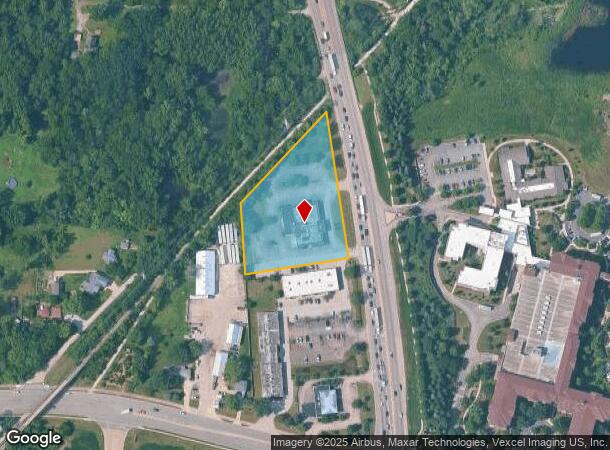
4S040 N Route 59, Warrenville, IL 60563
NEARBY LISTINGS FOR SALE OR LEASE
Property Detail
4S040 N Route 59
Chicago-Naperville-Elgin, IL-IN-WI
Dramour Corp Second Sub
07-03-100-006
DRAMOUR CORP SECOND SUB ALL
Commercialnec
DuPage
X
Illinois
17043C0137J
1
2024
2.17 AC
2024
Western East/West Corr
846411
Chicago
11,543 SF
DEMOGRAPHICS near 4S040 N Route 59
1 Mile
3 Mile
5 Mile
2024 Total Population
5,210
49,350
164,512
2029 Population
5,058
48,404
161,896
Pop Growth 2024-2029
(2.92%)
(1.92%)
(1.59%)
Average Age
41
39
39
2024 Total Households
2,046
19,565
61,269
HH Growth 2024-2029
(2.30%)
(1.83%)
(1.60%)
Median Household Inc
$92,282
$103,131
$106,708
Avg Household Size
2.40
2.40
2.60
2024 Avg HH Vehicles
2.00
2.00
2.00
Median Home Value
$244,351
$331,401
$359,920
Median Year Built
1977
1988
1987
Nearby Places
Map Layers
Map Styles
 Street
 Aerial
- Restaurants
- Banks
- Shops
- Fitness
- Groceries
PUBLIC TRANSPORTATION
COMMUTER RAIL
Route 59 Station (Burlington Northern-Santa Fe Railway Line - Northeast Illinois Regional Commuter Railroad (Metra))
DRIVE
WALK
Distance
Route 59 Station (Burlington Northern-Santa Fe Railway Line - Northeast Illinois Regional Commuter Railroad (Metra))
6 min
2.8 mi
Naperville Station (Burlington Northern-Santa Fe Railway Line - Northeast Illinois Regional Commuter Railroad (Metra))
DRIVE
WALK
Distance
Naperville Station (Burlington Northern-Santa Fe Railway Line - Northeast Illinois Regional Commuter Railroad (Metra))
11 min
5.2 mi
AIRPORT
Chicago Midway International
DRIVE
WALK
Distance
Chicago Midway International
44 min
29.0 mi
Chicago O'Hare International
DRIVE
WALK
Distance
Chicago O'Hare International
43 min
29.8 mi
SALE & LEASE HISTORY
LISTING DATE
SALE/LEASE

Jul 20, 2018
For Lease
Nearby Properties
Address
Land Use
TOTAL SIZE
Lot Size
Zoning
Address
Land Use
TOTAL SIZE
Lot Size
Zoning
20.60 AC
Address
Land Use
TOTAL SIZE
Lot Size
Zoning
47.26 AC
Address
Land Use
TOTAL SIZE
Lot Size
Zoning
17.59 AC
Address
Land Use
TOTAL SIZE
Lot Size
Zoning
41.42 AC
Address
Land Use
TOTAL SIZE
Lot Size
Zoning
19.94 AC
R
Address
Land Use
TOTAL SIZE
Lot Size
Zoning
31.66 AC
C
Address
Land Use
TOTAL SIZE
Lot Size
Zoning
17.70 AC
Address
Land Use
TOTAL SIZE
Lot Size
Zoning
797,399 SF
52.38 AC
C
Address
Land Use
TOTAL SIZE
Lot Size
Zoning
684,925 SF
25.63 AC
Address
Land Use
TOTAL SIZE
Lot Size
Zoning
272,400 SF
20.94 AC
C
Address
Land Use
TOTAL SIZE
Lot Size
Zoning
315,328 SF
5.06 AC
Address
Land Use
TOTAL SIZE
Lot Size
Zoning
25 AC
M
Address
Land Use
TOTAL SIZE
Lot Size
Zoning
5.43 AC
Address
Land Use
TOTAL SIZE
Lot Size
Zoning
266,118 SF
21.65 AC
C
Address
Land Use
TOTAL SIZE
Lot Size
Zoning
96.92 AC
I
Address
Land Use
TOTAL SIZE
Lot Size
Zoning
1,059,897 SF
122.10 AC
C
Address
Land Use
TOTAL SIZE
Lot Size
Zoning
721,600 SF
34.74 AC
I
Address
Land Use
TOTAL SIZE
Lot Size
Zoning
16.15 AC
M
Address
Land Use
TOTAL SIZE
Lot Size
Zoning
15.61 AC
M
Address
Land Use
TOTAL SIZE
Lot Size
Zoning
650,361 SF
27.79 AC
I
Address
Land Use
TOTAL SIZE
Lot Size
Zoning
31.08 AC
Address
Land Use
TOTAL SIZE
Lot Size
Zoning
Address
Land Use
TOTAL SIZE
Lot Size
Zoning
239,418 SF
21.27 AC
C
Address
Land Use
TOTAL SIZE
Lot Size
Zoning
505,720 SF
27.67 AC
Address
Land Use
TOTAL SIZE
Lot Size
Zoning
6.59 AC
Address
Land Use
TOTAL SIZE
Lot Size
Zoning
522,457 SF
29.33 AC
I
Address
Land Use
TOTAL SIZE
Lot Size
Zoning
23.45 AC
Address
Land Use
TOTAL SIZE
Lot Size
Zoning
16.86 AC
C
Address
Land Use
TOTAL SIZE
Lot Size
Zoning
397,771 SF
22.12 AC
Address
Land Use
TOTAL SIZE
Lot Size
Zoning
12.70 AC
The World's #1 Commercial Real Estate Marketplace
Connect with us
© 2026 CoStar Group
The information above has been obtained from sources believed reliable. While we do not doubt its accuracy we have not verified it and make no guarantee, warranty or representation about it. It is your responsibility to independently confirm its accuracy and completeness. Any projections, opinions, assumptions, or estimates used are for example only and do not represent the current or future performance of the property. The value of this transaction to you depends on tax and other factors which should be evaluated by your tax, financial, and legal advisors. You and your advisors should conduct a careful, independent investigation of the property to determine to your satisfaction the suitability of the property for your needs.