Property Record
401 N Holladay St, Cornelius, OR 97113

Current Lease Availabilities
NEARBY LISTINGS FOR SALE OR LEASE
Property Detail
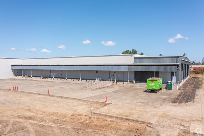
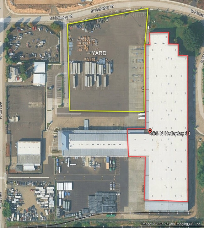
401 N Holladay St
Portland-Vancouver-Hillsboro, OR-WA
Tenth Avenue Industrial Center
R1008554
TENTH AVENUE INDUSTRIAL CENTER, LOT 1-2 & PTS 3, 15 & 16, ACRES 9.9, ADDL: CORNELIUS ENVIRONS LOT PT 28, CODE SPLIT
Industrialacreage
Washington
X
Oregon
41067C0314E
1-2
2024
0.92 AC
2026
Westside Outlying
032904
Portland
DEMOGRAPHICS near 401 N Holladay St
1 Mile
3 Mile
5 Mile
2024 Total Population
10,252
36,199
78,377
2029 Population
10,382
36,665
78,858
Pop Growth 2024-2029
+ 1.27%
+ 1.29%
+ 0.61%
Average Age
37
38
38
2024 Total Households
3,146
11,865
26,093
HH Growth 2024-2029
+ 1.37%
+ 1.39%
+ 0.67%
Median Household Inc
$58,918
$65,343
$77,932
Avg Household Size
3.20
2.90
2.90
2024 Avg HH Vehicles
2.00
2.00
2.00
Median Home Value
$318,444
$386,456
$436,064
Median Year Built
1979
1980
1983
Nearby Places
Map Layers
Map Styles
 Street
 Aerial
- Restaurants
- Banks
- Shops
- Fitness
- Groceries
PUBLIC TRANSPORTATION
AIRPORT
Portland International
DRIVE
WALK
Distance
Portland International
55 min
36.9 mi
Freight Ports
Port of Portland
DRIVE
WALK
Distance
Port of Portland
38 min
26.0 mi
Nearby Properties
Address
Land Use
TOTAL SIZE
Lot Size
Zoning
Address
Land Use
TOTAL SIZE
Lot Size
Zoning
608,403 SF
30.03 AC
RMH
Address
Land Use
TOTAL SIZE
Lot Size
Zoning
79,574 SF
16.54 AC
GI
Address
Land Use
TOTAL SIZE
Lot Size
Zoning
220,000 SF
35.85 AC
INST
Address
Land Use
TOTAL SIZE
Lot Size
Zoning
13.80 AC
GI
Address
Land Use
TOTAL SIZE
Lot Size
Zoning
108.84 AC
GI
Address
Land Use
TOTAL SIZE
Lot Size
Zoning
154,371 SF
15.63 AC
C2
Address
Land Use
TOTAL SIZE
Lot Size
Zoning
46,175 SF
28.39 AC
INST
Address
Land Use
TOTAL SIZE
Lot Size
Zoning
2.83 AC
GMU
Address
Land Use
TOTAL SIZE
Lot Size
Zoning
169,980 SF
14 AC
GMU
Address
Land Use
TOTAL SIZE
Lot Size
Zoning
37,000 SF
29.09 AC
INST
Address
Land Use
TOTAL SIZE
Lot Size
Zoning
65,500 SF
9.67 AC
R7
Address
Land Use
TOTAL SIZE
Lot Size
Zoning
0.05 AC
LI
Address
Land Use
TOTAL SIZE
Lot Size
Zoning
20.48 AC
LI
Address
Land Use
TOTAL SIZE
Lot Size
Zoning
222,852 SF
11.17 AC
RMH
Address
Land Use
TOTAL SIZE
Lot Size
Zoning
72,365 SF
11.25 AC
R7
Address
Land Use
TOTAL SIZE
Lot Size
Zoning
61,520 SF
2.02 AC
RMH
Address
Land Use
TOTAL SIZE
Lot Size
Zoning
46,000 SF
7.68 AC
INST
Address
Land Use
TOTAL SIZE
Lot Size
Zoning
59,902 SF
1.40 AC
RMH
Address
Land Use
TOTAL SIZE
Lot Size
Zoning
137,200 SF
9.52 AC
INST
Address
Land Use
TOTAL SIZE
Lot Size
Zoning
25,372 SF
5.99 AC
R-10
Address
Land Use
TOTAL SIZE
Lot Size
Zoning
176,108 SF
0.44 AC
CC
Address
Land Use
TOTAL SIZE
Lot Size
Zoning
19.02 AC
INST
Address
Land Use
TOTAL SIZE
Lot Size
Zoning
32,187 SF
9.19 AC
AF-5
Address
Land Use
TOTAL SIZE
Lot Size
Zoning
7.35 AC
Address
Land Use
TOTAL SIZE
Lot Size
Zoning
69,792 SF
7.75 AC
INST
Address
Land Use
TOTAL SIZE
Lot Size
Zoning
Address
Land Use
TOTAL SIZE
Lot Size
Zoning
1,210 SF
4.50 AC
CC
Address
Land Use
TOTAL SIZE
Lot Size
Zoning
47,110 SF
2.57 AC
RMH
Address
Land Use
TOTAL SIZE
Lot Size
Zoning
90,000 SF
5.39 AC
INST
Address
Land Use
TOTAL SIZE
Lot Size
Zoning
7,150 SF
7.22 AC
C-G
The World's #1 Commercial Real Estate Marketplace
Connect with us
© 2026 CoStar Group
The information above has been obtained from sources believed reliable. While we do not doubt its accuracy we have not verified it and make no guarantee, warranty or representation about it. It is your responsibility to independently confirm its accuracy and completeness. Any projections, opinions, assumptions, or estimates used are for example only and do not represent the current or future performance of the property. The value of this transaction to you depends on tax and other factors which should be evaluated by your tax, financial, and legal advisors. You and your advisors should conduct a careful, independent investigation of the property to determine to your satisfaction the suitability of the property for your needs.