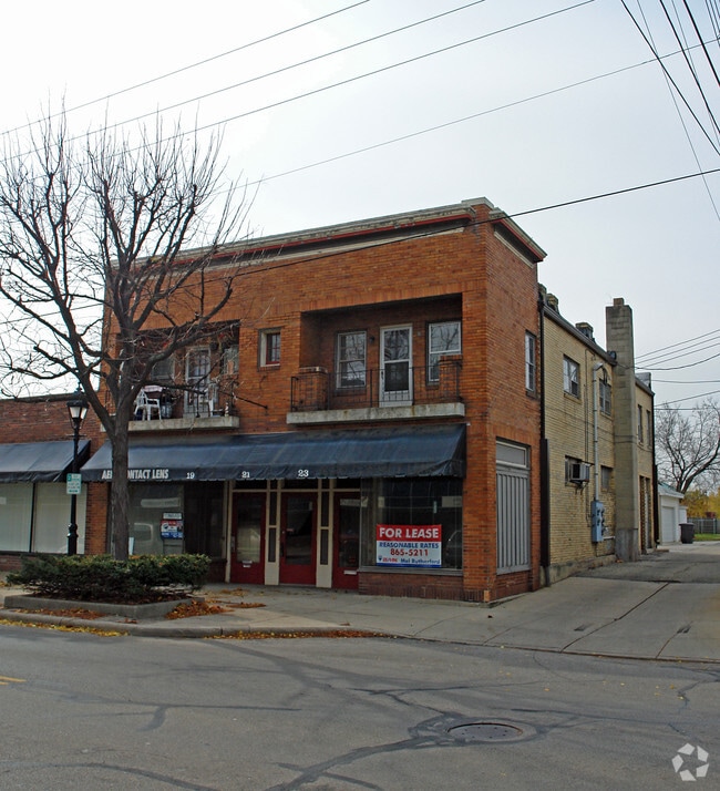
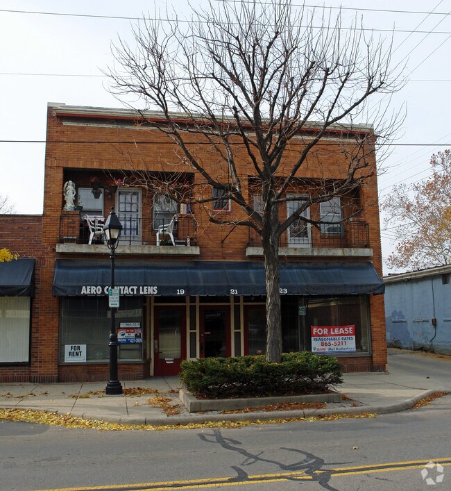
Property Record
19 N Elm St, Dayton, OH 45449
NEARBY LISTINGS FOR SALE OR LEASE
Property Detail
19 N Elm St
Dayton, OH
City/West Carrollton Rev
K48-00104-0103
32 PT
Storebuilding
Montgomery
X
Ohio
39113C0242E
103
2023
0.06 AC
2024
South Dayton
050301
Cincinnati/Dayton
4,652 SF
DEMOGRAPHICS near 19 N Elm St
1 Mile
3 Mile
5 Mile
2024 Total Population
5,574
45,735
102,436
2029 Population
5,457
45,137
101,116
Pop Growth 2024-2029
(2.10%)
(1.31%)
(1.29%)
Average Age
42
42
42
2024 Total Households
2,396
20,055
44,311
HH Growth 2024-2029
(2.13%)
(1.45%)
(1.43%)
Median Household Inc
$57,863
$57,680
$64,609
Avg Household Size
2.30
2.20
2.20
2024 Avg HH Vehicles
2.00
2.00
2.00
Median Home Value
$143,092
$156,445
$180,166
Median Year Built
1961
1971
1970
Nearby Places
- Restaurants
- Banks
- Shops
- Fitness
- Groceries
PUBLIC TRANSPORTATION
AIRPORT
James M Cox Dayton International
DRIVE
WALK
Distance
James M Cox Dayton International
30 min
20.3 mi
Freight Ports
Port of Toledo
DRIVE
WALK
Distance
Port of Toledo
187 min
160.5 mi
Nearby Properties
Address
Land Use
TOTAL SIZE
Lot Size
Zoning
Address
Land Use
TOTAL SIZE
Lot Size
Zoning
104,240 SF
36.80 AC
Address
Land Use
TOTAL SIZE
Lot Size
Zoning
Address
Land Use
TOTAL SIZE
Lot Size
Zoning
6,204 SF
19.27 AC
Address
Land Use
TOTAL SIZE
Lot Size
Zoning
94.06 AC
Address
Land Use
TOTAL SIZE
Lot Size
Zoning
145,322 SF
22.31 AC
Address
Land Use
TOTAL SIZE
Lot Size
Zoning
71,204 SF
5.15 AC
Address
Land Use
TOTAL SIZE
Lot Size
Zoning
131,742 SF
7.75 AC
Address
Land Use
TOTAL SIZE
Lot Size
Zoning
66.56 AC
Address
Land Use
TOTAL SIZE
Lot Size
Zoning
155,702 SF
5.95 AC
Address
Land Use
TOTAL SIZE
Lot Size
Zoning
414,124 SF
14.98 AC
Address
Land Use
TOTAL SIZE
Lot Size
Zoning
206,027 SF
28.63 AC
Address
Land Use
TOTAL SIZE
Lot Size
Zoning
70,234 SF
11.22 AC
Address
Land Use
TOTAL SIZE
Lot Size
Zoning
82,510 SF
12.79 AC
Address
Land Use
TOTAL SIZE
Lot Size
Zoning
109,750 SF
15.38 AC
Address
Land Use
TOTAL SIZE
Lot Size
Zoning
600,884 SF
38.61 AC
Address
Land Use
TOTAL SIZE
Lot Size
Zoning
22,590 SF
4.20 AC
Address
Land Use
TOTAL SIZE
Lot Size
Zoning
101,769 SF
20.65 AC
Address
Land Use
TOTAL SIZE
Lot Size
Zoning
162,528 SF
14.70 AC
Address
Land Use
TOTAL SIZE
Lot Size
Zoning
10,152 SF
7.57 AC
Address
Land Use
TOTAL SIZE
Lot Size
Zoning
439,169 SF
16 AC
Address
Land Use
TOTAL SIZE
Lot Size
Zoning
121,875 SF
8.21 AC
Address
Land Use
TOTAL SIZE
Lot Size
Zoning
84,046 SF
11.13 AC
Address
Land Use
TOTAL SIZE
Lot Size
Zoning
46,088 SF
29.95 AC
Address
Land Use
TOTAL SIZE
Lot Size
Zoning
129,829 SF
13.92 AC
Address
Land Use
TOTAL SIZE
Lot Size
Zoning
50,451 SF
6.12 AC
Address
Land Use
TOTAL SIZE
Lot Size
Zoning
144,981 SF
Address
Land Use
TOTAL SIZE
Lot Size
Zoning
68,705 SF
1.29 AC
Address
Land Use
TOTAL SIZE
Lot Size
Zoning
439,169 SF
16 AC
Address
Land Use
TOTAL SIZE
Lot Size
Zoning
79,197 SF
8.07 AC
Address
Land Use
TOTAL SIZE
Lot Size
Zoning
130,499 SF
10.64 AC
The World's #1 Commercial Real Estate Marketplace
Connect with us
© 2025 CoStar Group
The information above has been obtained from sources believed reliable. While we do not doubt its accuracy we have not verified it and make no guarantee, warranty or representation about it. It is your responsibility to independently confirm its accuracy and completeness. Any projections, opinions, assumptions, or estimates used are for example only and do not represent the current or future performance of the property. The value of this transaction to you depends on tax and other factors which should be evaluated by your tax, financial, and legal advisors. You and your advisors should conduct a careful, independent investigation of the property to determine to your satisfaction the suitability of the property for your needs.