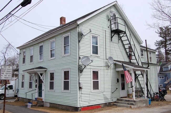
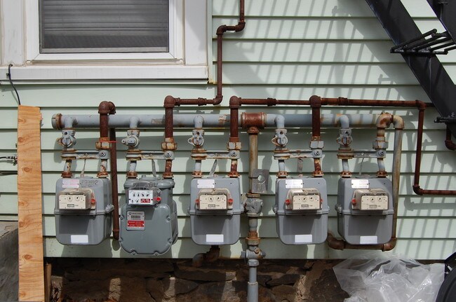
Property Record
5 Washington Ave, Franklin, NH 03235

NEARBY LISTINGS FOR SALE OR LEASE
Property Detail
5 Washington Ave
Concord, NH
Merrimack
FRKN-000115-000070
New Hampshire
Sfr
0.39 AC
X
Concord/New Hampshire North Area
33013C0159E
Other Market Areas
1,493 SF
DEMOGRAPHICS near 5 Washington Ave
1 Mile
3 Mile
5 Mile
2024 Total Population
5,162
15,944
23,278
2029 Population
5,465
16,820
24,529
Pop Growth 2024-2029
+ 5.87%
+ 5.49%
+ 5.37%
Average Age
41
41
42
2024 Total Households
2,204
6,195
8,904
HH Growth 2024-2029
+ 5.76%
+ 5.63%
+ 5.51%
Median Household Inc
$69,472
$79,799
$87,061
Avg Household Size
2.30
2.30
2.40
2024 Avg HH Vehicles
2.00
2.00
2.00
Median Home Value
$252,007
$267,722
$286,390
Median Year Built
1969
1982
1981
Nearby Places
Map Layers
Map Styles
 Street
 Aerial
- Restaurants
- Banks
- Shops
- Fitness
- Groceries
SALE & LEASE HISTORY
LISTING DATE
SALE/LEASE

Jun 27, 2019
For Sale
Nearby Properties
Address
Land Use
TOTAL SIZE
Lot Size
Zoning
Address
Land Use
TOTAL SIZE
Lot Size
Zoning
149,800 SF
28 AC
MEDIUM
Address
Land Use
TOTAL SIZE
Lot Size
Zoning
1.04 AC
MIXED
Address
Land Use
TOTAL SIZE
Lot Size
Zoning
118,611 SF
12.40 AC
VILLAG
Address
Land Use
TOTAL SIZE
Lot Size
Zoning
58,142 SF
7 AC
VILLAG
Address
Land Use
TOTAL SIZE
Lot Size
Zoning
19,172 SF
83 AC
C
Address
Land Use
TOTAL SIZE
Lot Size
Zoning
64,666 SF
8.65 AC
RSW&S
Address
Land Use
TOTAL SIZE
Lot Size
Zoning
Address
Land Use
TOTAL SIZE
Lot Size
Zoning
80,933 SF
3.79 AC
VILLAG
Address
Land Use
TOTAL SIZE
Lot Size
Zoning
16,833 SF
2.39 AC
B1W&S
Address
Land Use
TOTAL SIZE
Lot Size
Zoning
42,523 SF
32.89 AC
R1SFSS
Address
Land Use
TOTAL SIZE
Lot Size
Zoning
93,102 SF
8.21 AC
GENERA
Address
Land Use
TOTAL SIZE
Lot Size
Zoning
60.27 AC
R2MFSM
Address
Land Use
TOTAL SIZE
Lot Size
Zoning
83,283 SF
16.81 AC
RSW&S
Address
Land Use
TOTAL SIZE
Lot Size
Zoning
17,338 SF
4.07 AC
VILLAG
Address
Land Use
TOTAL SIZE
Lot Size
Zoning
38,159 SF
4 AC
R2MFSM
Address
Land Use
TOTAL SIZE
Lot Size
Zoning
94,330 SF
14.70 AC
B1W&S
Address
Land Use
TOTAL SIZE
Lot Size
Zoning
215,790 SF
18 AC
I1
Address
Land Use
TOTAL SIZE
Lot Size
Zoning
54,592 SF
B1W&S
Address
Land Use
TOTAL SIZE
Lot Size
Zoning
2,032 SF
59.56 AC
MEDIUM
Address
Land Use
TOTAL SIZE
Lot Size
Zoning
6.75 AC
GENERA
Address
Land Use
TOTAL SIZE
Lot Size
Zoning
8,038 SF
5.32 AC
MIXED
Address
Land Use
TOTAL SIZE
Lot Size
Zoning
35,163 SF
11.54 AC
VILLAG
Address
Land Use
TOTAL SIZE
Lot Size
Zoning
2,324 SF
388 AC
C
Address
Land Use
TOTAL SIZE
Lot Size
Zoning
44,129 SF
13.23 AC
RSW&S
Address
Land Use
TOTAL SIZE
Lot Size
Zoning
1,265 SF
0.13 AC
DOWNTO
Address
Land Use
TOTAL SIZE
Lot Size
Zoning
0.32 AC
C/I-1
Address
Land Use
TOTAL SIZE
Lot Size
Zoning
4,832 SF
1.37 AC
R3W&S
Address
Land Use
TOTAL SIZE
Lot Size
Zoning
65,308 SF
2.27 AC
B2
Address
Land Use
TOTAL SIZE
Lot Size
Zoning
44,955 SF
5.22 AC
B1W&S
Address
Land Use
TOTAL SIZE
Lot Size
Zoning
4,890 SF
1.30 AC
MIXED
The World's #1 Commercial Real Estate Marketplace
Connect with us
© 2025 CoStar Group
The information above has been obtained from sources believed reliable. While we do not doubt its accuracy we have not verified it and make no guarantee, warranty or representation about it. It is your responsibility to independently confirm its accuracy and completeness. Any projections, opinions, assumptions, or estimates used are for example only and do not represent the current or future performance of the property. The value of this transaction to you depends on tax and other factors which should be evaluated by your tax, financial, and legal advisors. You and your advisors should conduct a careful, independent investigation of the property to determine to your satisfaction the suitability of the property for your needs.