Property Record
3482 Wildwood St, Yorktown Heights, NY 10598
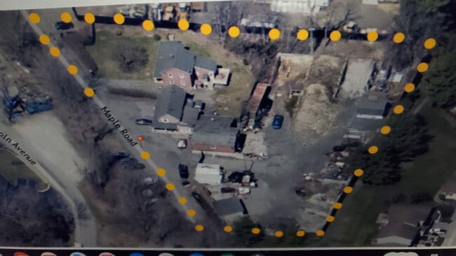
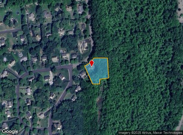
This Property Is For Sale
NEARBY LISTINGS FOR SALE OR LEASE
-
-
View all Yorktown Heights listings for sale on LoopNet.com
Property Detail
3482 Wildwood St
New York-Jersey City-White Plains, NY-NJ
Subdivision Plat Of Contemporary
5400-016-016-00001-000-0012
Westchester
Sfr
New York
X
0.98 AC
36079C0208E
North
2,484 SF
Westchester/So Connecticut
DEMOGRAPHICS near 3482 Wildwood St
1 Mile
3 Mile
5 Mile
2024 Total Population
2,175
23,865
64,584
2029 Population
2,110
23,509
63,540
Pop Growth 2024-2029
(2.99%)
(1.49%)
(1.62%)
Average Age
51
48
45
2024 Total Households
892
9,453
23,834
HH Growth 2024-2029
(3.14%)
(1.41%)
(1.70%)
Median Household Inc
$94,505
$130,003
$135,311
Avg Household Size
2.30
2.50
2.60
2024 Avg HH Vehicles
2.00
2.00
2.00
Median Home Value
$569,635
$511,285
$508,631
Median Year Built
1981
1977
1971
Nearby Places
- Restaurants
- Banks
- Shops
- Fitness
- Groceries
PUBLIC TRANSPORTATION
COMMUTER RAIL
Peekskill Station (Hudson Line - Metro-North Commuter Railroad Company (Metro-North))
DRIVE
WALK
Distance
Peekskill Station (Hudson Line - Metro-North Commuter Railroad Company (Metro-North))
15 min
8.3 mi
AIRPORT
Westchester County
DRIVE
WALK
Distance
Westchester County
35 min
25.4 mi
New York Stewart International
DRIVE
WALK
Distance
New York Stewart International
55 min
31.6 mi
Freight Ports
NY - Red Hook Container Terminal
DRIVE
WALK
Distance
NY - Red Hook Container Terminal
79 min
54.3 mi
Nearby Properties
Address
Land Use
TOTAL SIZE
Lot Size
Zoning
Address
Land Use
TOTAL SIZE
Lot Size
Zoning
1,656 SF
80.06 AC
R
Address
Land Use
TOTAL SIZE
Lot Size
Zoning
78,331 SF
37.78 AC
R2
Address
Land Use
TOTAL SIZE
Lot Size
Zoning
18,865 SF
161.60 AC
PD
Address
Land Use
TOTAL SIZE
Lot Size
Zoning
27.32 AC
Address
Land Use
TOTAL SIZE
Lot Size
Zoning
878 SF
62.50 AC
R1-20
Address
Land Use
TOTAL SIZE
Lot Size
Zoning
21,569 SF
61.43 AC
PD
Address
Land Use
TOTAL SIZE
Lot Size
Zoning
38,477 SF
7.12 AC
PH
Address
Land Use
TOTAL SIZE
Lot Size
Zoning
13 AC
R1-40
Address
Land Use
TOTAL SIZE
Lot Size
Zoning
1,632 SF
60.28 AC
PD
Address
Land Use
TOTAL SIZE
Lot Size
Zoning
221 SF
0.78 AC
R
Address
Land Use
TOTAL SIZE
Lot Size
Zoning
14,000 SF
10.03 AC
PH
Address
Land Use
TOTAL SIZE
Lot Size
Zoning
1,124 SF
8 AC
R1-80
Address
Land Use
TOTAL SIZE
Lot Size
Zoning
7,183 SF
5 AC
R1
Address
Land Use
TOTAL SIZE
Lot Size
Zoning
12,759 SF
17.16 AC
R2
Address
Land Use
TOTAL SIZE
Lot Size
Zoning
5,363 SF
4.82 AC
R2
Address
Land Use
TOTAL SIZE
Lot Size
Zoning
171.67 AC
R-120
Address
Land Use
TOTAL SIZE
Lot Size
Zoning
1,504 SF
45.28 AC
R1-80
Address
Land Use
TOTAL SIZE
Lot Size
Zoning
7,848 SF
5.79 AC
R2
Address
Land Use
TOTAL SIZE
Lot Size
Zoning
6,186 SF
14.13 AC
R2
Address
Land Use
TOTAL SIZE
Lot Size
Zoning
240 SF
25 AC
PD
Address
Land Use
TOTAL SIZE
Lot Size
Zoning
10.34 AC
NS
Address
Land Use
TOTAL SIZE
Lot Size
Zoning
9,992 SF
15.01 AC
R2
Address
Land Use
TOTAL SIZE
Lot Size
Zoning
92.25 AC
R2
Address
Land Use
TOTAL SIZE
Lot Size
Zoning
8,700 SF
2.78 AC
CN
Address
Land Use
TOTAL SIZE
Lot Size
Zoning
10,370 SF
11.33 AC
R3
Address
Land Use
TOTAL SIZE
Lot Size
Zoning
4,447 SF
8.12 AC
R3
Address
Land Use
TOTAL SIZE
Lot Size
Zoning
10,781 SF
9.29 AC
R2
Address
Land Use
TOTAL SIZE
Lot Size
Zoning
2.15 AC
R3
Address
Land Use
TOTAL SIZE
Lot Size
Zoning
2,355 SF
9.66 AC
R3
Address
Land Use
TOTAL SIZE
Lot Size
Zoning
5,760 SF
21.13 AC
R1
The World's #1 Commercial Real Estate Marketplace
Connect with us
© 2025 CoStar Group
The information above has been obtained from sources believed reliable. While we do not doubt its accuracy we have not verified it and make no guarantee, warranty or representation about it. It is your responsibility to independently confirm its accuracy and completeness. Any projections, opinions, assumptions, or estimates used are for example only and do not represent the current or future performance of the property. The value of this transaction to you depends on tax and other factors which should be evaluated by your tax, financial, and legal advisors. You and your advisors should conduct a careful, independent investigation of the property to determine to your satisfaction the suitability of the property for your needs.