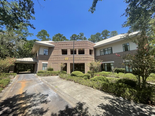
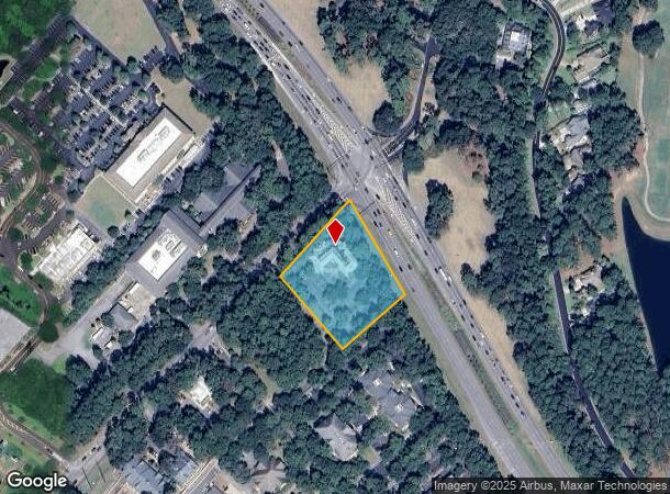
Property Record
5 Buck Island Rd, Bluffton, SC 29910
NEARBY LISTINGS FOR SALE OR LEASE
Property Detail
5 Buck Island Rd
Other Market Areas
Westbury Park Commercial
Hilton Head Island-Bluffton-Beaufort, SC
LOT 7 WESTBURY PARK COMM FKAWESTBURY PLACE S/D PB62 P163FKA LTS 6 7 WESTBURY PLA
R610-031-000-0205-0000
Beaufort
Officebuilding
South Carolina
2025
6-7
2024
1.90 AC
002107
Hilton Head/Beaufort
16,470 SF
DEMOGRAPHICS near 5 Buck Island Rd
1 Mile
3 Mile
5 Mile
2024 Total Population
4,560
23,404
48,691
2029 Population
4,975
25,724
54,192
Pop Growth 2024-2029
+ 9.10%
+ 9.91%
+ 11.30%
Average Age
42
41
44
2024 Total Households
1,787
8,896
19,315
HH Growth 2024-2029
+ 8.73%
+ 9.60%
+ 11.15%
Median Household Inc
$69,324
$72,248
$79,807
Avg Household Size
2.40
2.60
2.40
2024 Avg HH Vehicles
2.00
2.00
2.00
Median Home Value
$319,718
$356,159
$389,107
Median Year Built
2001
2003
2003
Nearby Places
Map Layers
Map Styles
 Street
 Aerial
- Restaurants
- Banks
- Shops
- Fitness
- Groceries
PUBLIC TRANSPORTATION
AIRPORT
Hilton Head
DRIVE
WALK
Distance
Hilton Head
20 min
12.8 mi
Savannah/Hilton Head International
DRIVE
WALK
Distance
Savannah/Hilton Head International
44 min
32.5 mi
Freight Ports
Georgia Ports - Savannah
DRIVE
WALK
Distance
Georgia Ports - Savannah
40 min
30.9 mi
Nearby Properties
Address
Land Use
TOTAL SIZE
Lot Size
Zoning
Address
Land Use
TOTAL SIZE
Lot Size
Zoning
239,031 SF
14.72 AC
6616
Address
Land Use
TOTAL SIZE
Lot Size
Zoning
170,736 SF
10.32 AC
6616
Address
Land Use
TOTAL SIZE
Lot Size
Zoning
156,459 SF
9.59 AC
Address
Land Use
TOTAL SIZE
Lot Size
Zoning
90,696 SF
62.80 AC
6616
Address
Land Use
TOTAL SIZE
Lot Size
Zoning
4,536 SF
17.73 AC
6606
Address
Land Use
TOTAL SIZE
Lot Size
Zoning
17,280 SF
10.77 AC
6616
Address
Land Use
TOTAL SIZE
Lot Size
Zoning
61,102 SF
12.20 AC
6606
Address
Land Use
TOTAL SIZE
Lot Size
Zoning
139,215 SF
13.63 AC
6106
Address
Land Use
TOTAL SIZE
Lot Size
Zoning
65,304 SF
27.78 AC
6606
Address
Land Use
TOTAL SIZE
Lot Size
Zoning
135,152 SF
14.03 AC
Address
Land Use
TOTAL SIZE
Lot Size
Zoning
119,800 SF
9.37 AC
Address
Land Use
TOTAL SIZE
Lot Size
Zoning
87,531 SF
21.48 AC
6106
Address
Land Use
TOTAL SIZE
Lot Size
Zoning
58,014 SF
11.18 AC
6616
Address
Land Use
TOTAL SIZE
Lot Size
Zoning
40,847 SF
3.79 AC
Address
Land Use
TOTAL SIZE
Lot Size
Zoning
30,305 SF
0.93 AC
Address
Land Use
TOTAL SIZE
Lot Size
Zoning
125,348 SF
9.75 AC
6616
Address
Land Use
TOTAL SIZE
Lot Size
Zoning
54,614 SF
142.72 AC
6616
Address
Land Use
TOTAL SIZE
Lot Size
Zoning
38,694 SF
9.56 AC
Address
Land Use
TOTAL SIZE
Lot Size
Zoning
29,549 SF
17.88 AC
6106
Address
Land Use
TOTAL SIZE
Lot Size
Zoning
79,616 SF
23.51 AC
6616
Address
Land Use
TOTAL SIZE
Lot Size
Zoning
42,521 SF
20.19 AC
4206
Address
Land Use
TOTAL SIZE
Lot Size
Zoning
102,252 SF
17.35 AC
6616
Address
Land Use
TOTAL SIZE
Lot Size
Zoning
4.30 AC
6606
Address
Land Use
TOTAL SIZE
Lot Size
Zoning
63,849 SF
10.80 AC
6616
Address
Land Use
TOTAL SIZE
Lot Size
Zoning
56,708 SF
9.96 AC
6616
Address
Land Use
TOTAL SIZE
Lot Size
Zoning
69,752 SF
4.16 AC
6606
Address
Land Use
TOTAL SIZE
Lot Size
Zoning
2,925 SF
563.49 AC
6816
Address
Land Use
TOTAL SIZE
Lot Size
Zoning
8,704 SF
12.35 AC
6616
Address
Land Use
TOTAL SIZE
Lot Size
Zoning
40,600 SF
10.11 AC
6616
The World's #1 Commercial Real Estate Marketplace
Connect with us
© 2025 CoStar Group
The information above has been obtained from sources believed reliable. While we do not doubt its accuracy we have not verified it and make no guarantee, warranty or representation about it. It is your responsibility to independently confirm its accuracy and completeness. Any projections, opinions, assumptions, or estimates used are for example only and do not represent the current or future performance of the property. The value of this transaction to you depends on tax and other factors which should be evaluated by your tax, financial, and legal advisors. You and your advisors should conduct a careful, independent investigation of the property to determine to your satisfaction the suitability of the property for your needs.