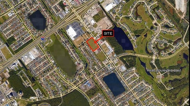
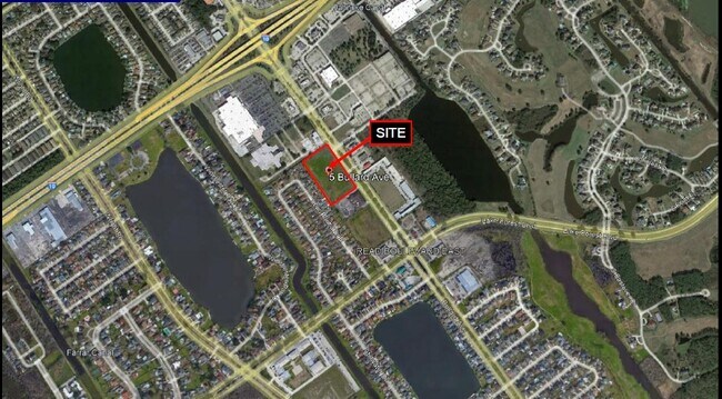
Property Record
5900 Bullard Ave, New Orleans, LA 70128
This Property Is For Sale
NEARBY LISTINGS FOR SALE OR LEASE
Property Detail
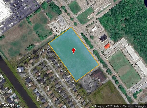
5900 Bullard Ave
New Orleans-Metairie, LA
Sec 26
3-9W-0-165-41
SQ SECTION 26 LOT 4-A-6A BULLARD AV 656 X 399 6.0236 ACRES VACANT
Commercialacreage
Orleans
AE
Louisiana
22087C0225D
4a6a
2025
6.02 AC
2025
New Orleans East
001747
New Orleans/Metairie/Kenner
DEMOGRAPHICS near 5900 Bullard Ave
1 Mile
3 Mile
5 Mile
2024 Total Population
8,568
53,412
68,873
2029 Population
8,194
50,656
65,498
Pop Growth 2024-2029
(4.37%)
(5.16%)
(4.90%)
Average Age
42
39
39
2024 Total Households
3,277
19,268
24,807
HH Growth 2024-2029
(4.49%)
(5.46%)
(5.16%)
Median Household Inc
$49,437
$35,576
$33,810
Avg Household Size
2.60
2.70
2.70
2024 Avg HH Vehicles
2.00
1.00
1.00
Median Home Value
$254,177
$178,848
$176,928
Median Year Built
1981
1977
1976
Nearby Places
- Restaurants
- Banks
- Shops
- Fitness
- Groceries
PUBLIC TRANSPORTATION
AIRPORT
Louis Armstrong New Orleans International
DRIVE
WALK
Distance
Louis Armstrong New Orleans International
30 min
22.0 mi
Freight Ports
Port of New Orleans
DRIVE
WALK
Distance
Port of New Orleans
24 min
14.4 mi
Nearby Properties
Address
Land Use
TOTAL SIZE
Lot Size
Zoning
Address
Land Use
TOTAL SIZE
Lot Size
Zoning
Address
Land Use
TOTAL SIZE
Lot Size
Zoning
286.90 AC
HI
Address
Land Use
TOTAL SIZE
Lot Size
Zoning
21.35 AC
S-RS
Address
Land Use
TOTAL SIZE
Lot Size
Zoning
21.58 AC
C-3
Address
Land Use
TOTAL SIZE
Lot Size
Zoning
136,984 SF
11.29 AC
S-RD
Address
Land Use
TOTAL SIZE
Lot Size
Zoning
109,239 SF
5.77 AC
S-RS
Address
Land Use
TOTAL SIZE
Lot Size
Zoning
115,600 SF
16.96 AC
S-B2
Address
Land Use
TOTAL SIZE
Lot Size
Zoning
42.84 AC
HI
Address
Land Use
TOTAL SIZE
Lot Size
Zoning
95,308 SF
16.36 AC
S-RS
Address
Land Use
TOTAL SIZE
Lot Size
Zoning
99,015 SF
6.99 AC
S-RS
Address
Land Use
TOTAL SIZE
Lot Size
Zoning
105,907 SF
3.84 AC
OS-N
Address
Land Use
TOTAL SIZE
Lot Size
Zoning
13,302 SF
53.89 AC
OS-R
Address
Land Use
TOTAL SIZE
Lot Size
Zoning
9.27 AC
S-B2
Address
Land Use
TOTAL SIZE
Lot Size
Zoning
20.58 AC
S-RS
Address
Land Use
TOTAL SIZE
Lot Size
Zoning
42.84 AC
HI
Address
Land Use
TOTAL SIZE
Lot Size
Zoning
179,095 SF
18.13 AC
C-3
Address
Land Use
TOTAL SIZE
Lot Size
Zoning
205,380 SF
16.49 AC
MS
Address
Land Use
TOTAL SIZE
Lot Size
Zoning
13,563 SF
81.46 AC
OS-R
Address
Land Use
TOTAL SIZE
Lot Size
Zoning
33.59 AC
S-RS
Address
Land Use
TOTAL SIZE
Lot Size
Zoning
19.84 AC
BIP
Address
Land Use
TOTAL SIZE
Lot Size
Zoning
17.83 AC
OS-R
Address
Land Use
TOTAL SIZE
Lot Size
Zoning
280,168 SF
11.47 AC
S-RM2
Address
Land Use
TOTAL SIZE
Lot Size
Zoning
83,918 SF
8.08 AC
S-RD
Address
Land Use
TOTAL SIZE
Lot Size
Zoning
4.09 AC
S-RD
Address
Land Use
TOTAL SIZE
Lot Size
Zoning
147,600 SF
14.18 AC
C-3
Address
Land Use
TOTAL SIZE
Lot Size
Zoning
265,000 SF
11.93 AC
S-RM2
Address
Land Use
TOTAL SIZE
Lot Size
Zoning
42.84 AC
HI
Address
Land Use
TOTAL SIZE
Lot Size
Zoning
202,568 SF
1 AC
Address
Land Use
TOTAL SIZE
Lot Size
Zoning
65,184 SF
1.73 AC
C-2
Address
Land Use
TOTAL SIZE
Lot Size
Zoning
1.05 AC
C-3
The World's #1 Commercial Real Estate Marketplace
Connect with us
© 2025 CoStar Group
The information above has been obtained from sources believed reliable. While we do not doubt its accuracy we have not verified it and make no guarantee, warranty or representation about it. It is your responsibility to independently confirm its accuracy and completeness. Any projections, opinions, assumptions, or estimates used are for example only and do not represent the current or future performance of the property. The value of this transaction to you depends on tax and other factors which should be evaluated by your tax, financial, and legal advisors. You and your advisors should conduct a careful, independent investigation of the property to determine to your satisfaction the suitability of the property for your needs.