Property Record
5 Commack Rd, Commack, NY 11725

Save to a Folder
{{folder.Name}}
{{folder.ListingIds.length}} Properties
{{folder.ListingIds.length}} Property
Create a New Folder
Property Detail
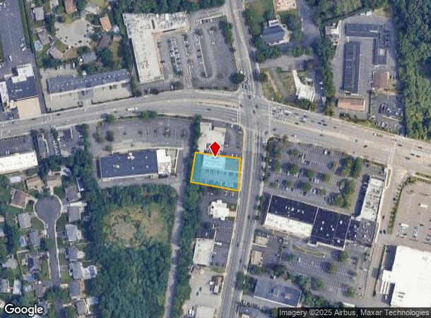
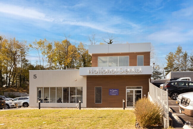
5 Commack Rd
Nassau County-Suffolk County, NY
SUFFOLK
0400-224-00-02-00-021-003
New York
Officebuilding
21
B and X Area of moderate flood hazard, usually the area between the limits of the 100-year and 500-year floods.
0.77 AC
2024
Western Suffolk
2025
Long Island (New York)
112103
NEARBY LISTINGS FOR SALE OR LEASE
DEMOGRAPHICS near 5 Commack Rd
1 mile
3 mile
5 mile
2025 Total Population
11,220
69,557
192,408
2030 Population
11,152
69,091
190,027
Pop Growth 2025-2030
(0.61%)
(0.67%)
(1.24%)
Average Age
43
43
42
2025 Total Households
3,672
22,565
59,636
HH Growth 2025-2030
(0.98%)
(1.05%)
(1.51%)
Median Household Inc
$165,158
$164,537
$153,769
Avg Household Size
2.90
3.00
3.00
2025 Avg HH Vehicles
2.00
2.00
2.00
Median Home Value
$724,636
$741,766
$717,229
Median Year Built
1961
1964
1964
Nearby Places
Map Layers
Map Styles
 Street
 Aerial
Layers
 Traffic
 Biking
Places
Listings with unknown addresses are not visible on the map
- Restaurants
- Banks
- Shops
- Fitness
- Groceries
PUBLIC TRANSPORTATION
COMMUTER RAIL
Northport Station (Port Jefferson Branch - Long Island Rail Road)
Drive
Walk
Distance
Northport Station (Port Jefferson Branch - Long Island Rail Road)
10 min
4.2 mi
Kings Park Station (Port Jefferson Branch - Long Island Rail Road)
Drive
Walk
Distance
Kings Park Station (Port Jefferson Branch - Long Island Rail Road)
8 min
4.9 mi
AIRPORT
Long Island MacArthur
Drive
Walk
Distance
Long Island MacArthur
19 min
11.6 mi
John F Kennedy International
Drive
Walk
Distance
John F Kennedy International
53 min
39.2 mi
Freight Ports
NY - Red Hook Container Terminal
Drive
Walk
Distance
NY - Red Hook Container Terminal
66 min
44.9 mi
Nearby Properties
Address
Land Use
TOTAL SIZE
Lot Size
Zoning
Address
Land Use
TOTAL SIZE
Lot Size
Zoning
26.60 AC
Address
Land Use
TOTAL SIZE
Lot Size
Zoning
3.01 AC
GSE
Address
Land Use
TOTAL SIZE
Lot Size
Zoning
2,096 SF
1.32 AC
R40
Address
Land Use
TOTAL SIZE
Lot Size
Zoning
21.50 AC
Address
Land Use
TOTAL SIZE
Lot Size
Zoning
3.63 AC
IND2
Address
Land Use
TOTAL SIZE
Lot Size
Zoning
22.80 AC
Address
Land Use
TOTAL SIZE
Lot Size
Zoning
14.13 AC
Address
Land Use
TOTAL SIZE
Lot Size
Zoning
23.60 AC
Address
Land Use
TOTAL SIZE
Lot Size
Zoning
Address
Land Use
TOTAL SIZE
Lot Size
Zoning
8.90 AC
BUS3
Address
Land Use
TOTAL SIZE
Lot Size
Zoning
12.30 AC
Address
Land Use
TOTAL SIZE
Lot Size
Zoning
17.20 AC
Address
Land Use
TOTAL SIZE
Lot Size
Zoning
6.41 AC
Address
Land Use
TOTAL SIZE
Lot Size
Zoning
10.40 AC
B
Address
Land Use
TOTAL SIZE
Lot Size
Zoning
88,200 SF
11.20 AC
Address
Land Use
TOTAL SIZE
Lot Size
Zoning
9.30 AC
Address
Land Use
TOTAL SIZE
Lot Size
Zoning
15.70 AC
Address
Land Use
TOTAL SIZE
Lot Size
Zoning
12.80 AC
Address
Land Use
TOTAL SIZE
Lot Size
Zoning
6.75 AC
Address
Land Use
TOTAL SIZE
Lot Size
Zoning
1.90 AC
IND2
Address
Land Use
TOTAL SIZE
Lot Size
Zoning
8.80 AC
R10
Address
Land Use
TOTAL SIZE
Lot Size
Zoning
15.60 AC
Address
Land Use
TOTAL SIZE
Lot Size
Zoning
2.42 AC
IND1
Address
Land Use
TOTAL SIZE
Lot Size
Zoning
148.70 AC
R40
Address
Land Use
TOTAL SIZE
Lot Size
Zoning
Address
Land Use
TOTAL SIZE
Lot Size
Zoning
Address
Land Use
TOTAL SIZE
Lot Size
Zoning
142,732 SF
16.90 AC
Address
Land Use
TOTAL SIZE
Lot Size
Zoning
9.30 AC
Address
Land Use
TOTAL SIZE
Lot Size
Zoning
Address
Land Use
TOTAL SIZE
Lot Size
Zoning
1.16 AC
BUS3
The World's #1 Commercial Real Estate Marketplace
Connect with us
© 2026 CoStar Group
The information above has been obtained from sources believed reliable. While we do not doubt its accuracy we have not verified it and make no guarantee, warranty or representation about it. It is your responsibility to independently confirm its accuracy and completeness. Any projections, opinions, assumptions, or estimates used are for example only and do not represent the current or future performance of the property. The value of this transaction to you depends on tax and other factors which should be evaluated by your tax, financial, and legal advisors. You and your advisors should conduct a careful, independent investigation of the property to determine to your satisfaction the suitability of the property for your needs.