Property Record
5 Dark Lane Rd, New Ipswich, NH 03071
NEARBY LISTINGS FOR SALE OR LEASE
-
-
View all New Ipswich listings for sale on LoopNet.com
Property Detail
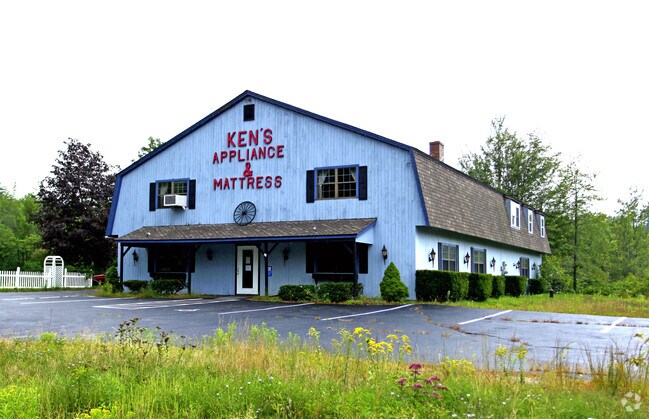
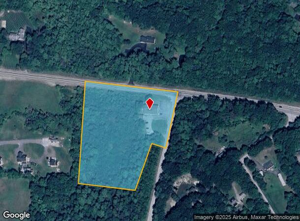
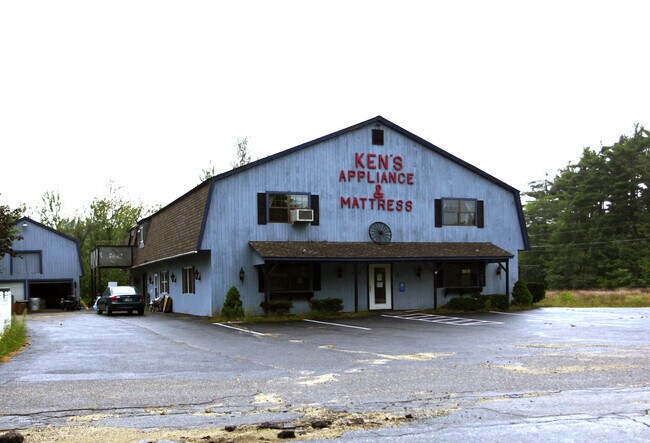
5 Dark Lane Rd
NIPS-000007-000000-000037-A000000
Hillsborough
Commercialbuilding
New Hampshire
X
37
33011C0440D
4.94 AC
2024
Hillsborough
2024
Boston
022502
Manchester-Nashua, NH
7,064 SF
DEMOGRAPHICS near 5 Dark Lane Rd
1 Mile
3 Mile
5 Mile
2024 Total Population
1,083
5,065
9,453
2029 Population
1,105
5,142
9,587
Pop Growth 2024-2029
+ 2.03%
+ 1.52%
+ 1.42%
Average Age
40
40
41
2024 Total Households
391
1,839
3,523
HH Growth 2024-2029
+ 2.05%
+ 1.41%
+ 1.33%
Median Household Inc
$87,019
$87,136
$88,774
Avg Household Size
2.80
2.80
2.70
2024 Avg HH Vehicles
2.00
2.00
2.00
Median Home Value
$291,666
$308,545
$307,269
Median Year Built
1981
1982
1980
Nearby Places
Map Layers
Map Styles
 Street
 Aerial
- Restaurants
- Banks
- Shops
- Fitness
- Groceries
PUBLIC TRANSPORTATION
AIRPORT
Manchester Boston Regional
DRIVE
WALK
Distance
Manchester Boston Regional
65 min
35.2 mi
Worcester Regional
DRIVE
WALK
Distance
Worcester Regional
74 min
46.7 mi
Freight Ports
Port of Boston
DRIVE
WALK
Distance
Port of Boston
99 min
57.7 mi
Nearby Properties
Address
Land Use
TOTAL SIZE
Lot Size
Zoning
Address
Land Use
TOTAL SIZE
Lot Size
Zoning
72,489 SF
114.26 AC
RD R
Address
Land Use
TOTAL SIZE
Lot Size
Zoning
74,751 SF
16.30 AC
VD2 V
Address
Land Use
TOTAL SIZE
Lot Size
Zoning
32,286 SF
2.70 AC
DOWNTO
Address
Land Use
TOTAL SIZE
Lot Size
Zoning
20,133 SF
16.34 AC
RA R
Address
Land Use
TOTAL SIZE
Lot Size
Zoning
4,783 SF
3.50 AC
RA R
Address
Land Use
TOTAL SIZE
Lot Size
Zoning
4,604 SF
1 AC
RES DI
Address
Land Use
TOTAL SIZE
Lot Size
Zoning
7,237 SF
4.90 AC
RD R
Address
Land Use
TOTAL SIZE
Lot Size
Zoning
16,616 SF
0.79 AC
DOWNTO
Address
Land Use
TOTAL SIZE
Lot Size
Zoning
10,792 SF
5.73 AC
RD R
Address
Land Use
TOTAL SIZE
Lot Size
Zoning
14,424 SF
3.01 AC
RD R
Address
Land Use
TOTAL SIZE
Lot Size
Zoning
23,495 SF
4.40 AC
RD R
Address
Land Use
TOTAL SIZE
Lot Size
Zoning
78,699 SF
9 AC
RD R
Address
Land Use
TOTAL SIZE
Lot Size
Zoning
31,281 SF
7.60 AC
VD1 V
Address
Land Use
TOTAL SIZE
Lot Size
Zoning
4,328 SF
19.02 AC
VD2 V
Address
Land Use
TOTAL SIZE
Lot Size
Zoning
5,582 SF
9.40 AC
RD R
Address
Land Use
TOTAL SIZE
Lot Size
Zoning
8,027 SF
0.56 AC
DOWNTO
Address
Land Use
TOTAL SIZE
Lot Size
Zoning
5,411 SF
3.40 AC
RD R
Address
Land Use
TOTAL SIZE
Lot Size
Zoning
10,038 SF
0.24 AC
DOWNTO
Address
Land Use
TOTAL SIZE
Lot Size
Zoning
8,674 SF
3.30 AC
RD R
Address
Land Use
TOTAL SIZE
Lot Size
Zoning
14,072 SF
17.68 AC
RD R
Address
Land Use
TOTAL SIZE
Lot Size
Zoning
20,206 SF
5.05 AC
RD R
Address
Land Use
TOTAL SIZE
Lot Size
Zoning
5,469 SF
4.89 AC
RD R
Address
Land Use
TOTAL SIZE
Lot Size
Zoning
10,917 SF
14.59 AC
RD R
Address
Land Use
TOTAL SIZE
Lot Size
Zoning
2,618 SF
9.24 AC
RD R
Address
Land Use
TOTAL SIZE
Lot Size
Zoning
7,918 SF
78 AC
VD2 V
Address
Land Use
TOTAL SIZE
Lot Size
Zoning
9,257 SF
4.75 AC
RD R
Address
Land Use
TOTAL SIZE
Lot Size
Zoning
7,911 SF
1 AC
VD2 V
Address
Land Use
TOTAL SIZE
Lot Size
Zoning
4,100 SF
4.04 AC
RD R
Address
Land Use
TOTAL SIZE
Lot Size
Zoning
524 SF
138 AC
RD R
Address
Land Use
TOTAL SIZE
Lot Size
Zoning
3,454 SF
0.28 AC
DOWNTO
The World's #1 Commercial Real Estate Marketplace
Connect with us
© 2025 CoStar Group
The information above has been obtained from sources believed reliable. While we do not doubt its accuracy we have not verified it and make no guarantee, warranty or representation about it. It is your responsibility to independently confirm its accuracy and completeness. Any projections, opinions, assumptions, or estimates used are for example only and do not represent the current or future performance of the property. The value of this transaction to you depends on tax and other factors which should be evaluated by your tax, financial, and legal advisors. You and your advisors should conduct a careful, independent investigation of the property to determine to your satisfaction the suitability of the property for your needs.