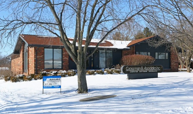
Property Record
5 Dunlap Ct, Savoy, IL 61874


NEARBY LISTINGS FOR SALE OR LEASE
Property Detail
5 Dunlap Ct
Champaign-Urbana, IL
Arbours Sub No 5
03-20-25-177-001
LOT 1 ARBOURS SUB NO 5
Taxexempt
Champaign
X
Illinois
17019C0428D
1
2022
0.80 AC
2024
Champaign-Urbana
001302
Other Market Areas
DEMOGRAPHICS near 5 Dunlap Ct
1 Mile
3 Mile
5 Mile
2024 Total Population
6,393
87,824
147,283
2029 Population
6,428
88,030
147,538
Pop Growth 2024-2029
+ 0.55%
+ 0.23%
+ 0.17%
Average Age
44
33
35
2024 Total Households
2,904
35,436
61,388
HH Growth 2024-2029
+ 0.55%
+ 0.36%
+ 0.21%
Median Household Inc
$72,231
$49,585
$51,376
Avg Household Size
2.10
2.00
2.10
2024 Avg HH Vehicles
2.00
1.00
1.00
Median Home Value
$221,237
$207,922
$185,458
Median Year Built
1980
1980
1983
Nearby Places
Map Layers
Map Styles
 Street
 Aerial
- Restaurants
- Banks
- Shops
- Fitness
- Groceries
PUBLIC TRANSPORTATION
COMMUTER RAIL
DRIVE
WALK
Distance
7 min
2.7 mi
AIRPORT
University of Illinois/Willard
DRIVE
WALK
Distance
University of Illinois/Willard
18 min
7.7 mi
SALE & LEASE HISTORY
LISTING DATE
SALE/LEASE

Jan 19, 2018
For Sale
Nearby Properties
Address
Land Use
TOTAL SIZE
Lot Size
Zoning
Address
Land Use
TOTAL SIZE
Lot Size
Zoning
10.70 AC
Address
Land Use
TOTAL SIZE
Lot Size
Zoning
0.56 AC
Address
Land Use
TOTAL SIZE
Lot Size
Zoning
Address
Land Use
TOTAL SIZE
Lot Size
Zoning
0.82 AC
Address
Land Use
TOTAL SIZE
Lot Size
Zoning
Address
Land Use
TOTAL SIZE
Lot Size
Zoning
Address
Land Use
TOTAL SIZE
Lot Size
Zoning
1.31 AC
Address
Land Use
TOTAL SIZE
Lot Size
Zoning
0.18 AC
Address
Land Use
TOTAL SIZE
Lot Size
Zoning
Address
Land Use
TOTAL SIZE
Lot Size
Zoning
0.75 AC
Address
Land Use
TOTAL SIZE
Lot Size
Zoning
120.50 AC
Address
Land Use
TOTAL SIZE
Lot Size
Zoning
0.20 AC
Address
Land Use
TOTAL SIZE
Lot Size
Zoning
0.81 AC
Address
Land Use
TOTAL SIZE
Lot Size
Zoning
1.85 AC
Address
Land Use
TOTAL SIZE
Lot Size
Zoning
0.70 AC
Address
Land Use
TOTAL SIZE
Lot Size
Zoning
Address
Land Use
TOTAL SIZE
Lot Size
Zoning
12.42 AC
Address
Land Use
TOTAL SIZE
Lot Size
Zoning
14.39 AC
Address
Land Use
TOTAL SIZE
Lot Size
Zoning
0.22 AC
Address
Land Use
TOTAL SIZE
Lot Size
Zoning
2.01 AC
Address
Land Use
TOTAL SIZE
Lot Size
Zoning
Address
Land Use
TOTAL SIZE
Lot Size
Zoning
Address
Land Use
TOTAL SIZE
Lot Size
Zoning
Address
Land Use
TOTAL SIZE
Lot Size
Zoning
0.18 AC
Address
Land Use
TOTAL SIZE
Lot Size
Zoning
Address
Land Use
TOTAL SIZE
Lot Size
Zoning
0.39 AC
Address
Land Use
TOTAL SIZE
Lot Size
Zoning
0.74 AC
Address
Land Use
TOTAL SIZE
Lot Size
Zoning
Address
Land Use
TOTAL SIZE
Lot Size
Zoning
0.53 AC
Address
Land Use
TOTAL SIZE
Lot Size
Zoning
789 SF
0.20 AC
The World's #1 Commercial Real Estate Marketplace
Connect with us
© 2025 CoStar Group
The information above has been obtained from sources believed reliable. While we do not doubt its accuracy we have not verified it and make no guarantee, warranty or representation about it. It is your responsibility to independently confirm its accuracy and completeness. Any projections, opinions, assumptions, or estimates used are for example only and do not represent the current or future performance of the property. The value of this transaction to you depends on tax and other factors which should be evaluated by your tax, financial, and legal advisors. You and your advisors should conduct a careful, independent investigation of the property to determine to your satisfaction the suitability of the property for your needs.