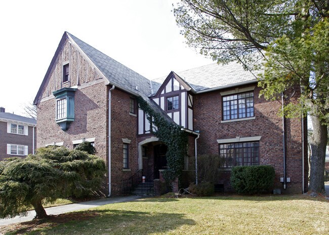
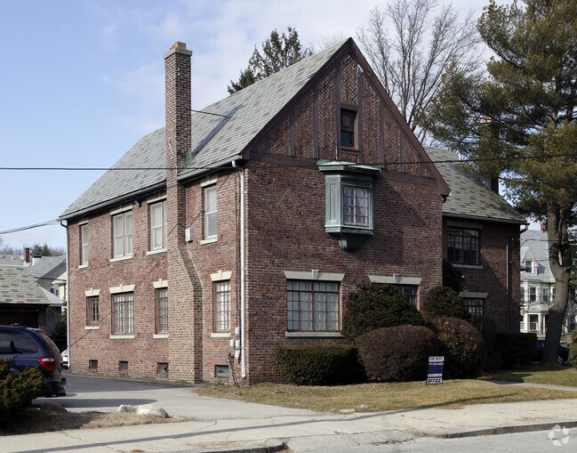
Property Record
5 Elmgrove Ave, Providence, RI 02906
NEARBY LISTINGS FOR SALE OR LEASE
Property Detail
5 Elmgrove Ave
SMIT-000037-000000-000014
Providence
Residentialacreage
Rhode Island
X
14
44007C0282G
0.06 AC
2025
Providence
2025
Providence
003500
Providence-Warwick, RI-MA
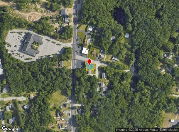
DEMOGRAPHICS near 5 Elmgrove Ave
1 Mile
3 Mile
5 Mile
2024 Total Population
27,481
193,329
418,735
2029 Population
27,279
191,533
414,216
Pop Growth 2024-2029
(0.74%)
(0.93%)
(1.08%)
Average Age
36
37
38
2024 Total Households
10,172
76,928
165,468
HH Growth 2024-2029
(0.74%)
(0.82%)
(1.04%)
Median Household Inc
$89,408
$58,963
$62,318
Avg Household Size
2.00
2.30
2.40
2024 Avg HH Vehicles
1.00
1.00
2.00
Median Home Value
$598,656
$305,339
$287,460
Median Year Built
1946
1948
1949
Nearby Places
Map Layers
Map Styles
 Street
 Aerial
- Restaurants
- Banks
- Shops
- Fitness
- Groceries
PUBLIC TRANSPORTATION
COMMUTER RAIL
Providence (Providence/Stoughton Line - Massachusetts Bay Transportation Authority Commuter Rail (Purple Line))
DRIVE
WALK
Distance
Providence (Providence/Stoughton Line - Massachusetts Bay Transportation Authority Commuter Rail (Purple Line))
13 min
7.8 mi
Pawtucket/Central Falls (Foxboro Event Service - MBTA, Providence/Stoughton Line - MBTA)
DRIVE
WALK
Distance
Pawtucket/Central Falls (Foxboro Event Service - MBTA, Providence/Stoughton Line - MBTA)
13 min
8.3 mi
AIRPORT
Rhode Island Tf Green International
DRIVE
WALK
Distance
Rhode Island Tf Green International
23 min
14.6 mi
Freight Ports
Port of Davisville, RI
DRIVE
WALK
Distance
Port of Davisville, RI
35 min
23.8 mi
SALE & LEASE HISTORY
LISTING DATE
SALE/LEASE

Dec 13, 2016
For Lease
Nearby Properties
Address
Land Use
TOTAL SIZE
Lot Size
Zoning
Address
Land Use
TOTAL SIZE
Lot Size
Zoning
89.07 AC
PD
Address
Land Use
TOTAL SIZE
Lot Size
Zoning
53.18 AC
C
Address
Land Use
TOTAL SIZE
Lot Size
Zoning
123.25 AC
R40
Address
Land Use
TOTAL SIZE
Lot Size
Zoning
1,792 SF
28.46 AC
Address
Land Use
TOTAL SIZE
Lot Size
Zoning
30.14 AC
R40
Address
Land Use
TOTAL SIZE
Lot Size
Zoning
166,368 SF
10.74 AC
R20
Address
Land Use
TOTAL SIZE
Lot Size
Zoning
175,231 SF
9.37 AC
Address
Land Use
TOTAL SIZE
Lot Size
Zoning
31.11 AC
R20M
Address
Land Use
TOTAL SIZE
Lot Size
Zoning
Address
Land Use
TOTAL SIZE
Lot Size
Zoning
185,010 SF
7.75 AC
MG
Address
Land Use
TOTAL SIZE
Lot Size
Zoning
1 AC
R40
Address
Land Use
TOTAL SIZE
Lot Size
Zoning
56,451 SF
5 AC
C
Address
Land Use
TOTAL SIZE
Lot Size
Zoning
22,868 SF
12.22 AC
R20
Address
Land Use
TOTAL SIZE
Lot Size
Zoning
124,397 SF
13.66 AC
C
Address
Land Use
TOTAL SIZE
Lot Size
Zoning
89,788 SF
11.25 AC
R20
Address
Land Use
TOTAL SIZE
Lot Size
Zoning
72,531 SF
11.70 AC
R20
Address
Land Use
TOTAL SIZE
Lot Size
Zoning
9.59 AC
MU
Address
Land Use
TOTAL SIZE
Lot Size
Zoning
20 AC
R20M
Address
Land Use
TOTAL SIZE
Lot Size
Zoning
54,645 SF
13.40 AC
RMED
Address
Land Use
TOTAL SIZE
Lot Size
Zoning
102,497 SF
4.74 AC
RG
Address
Land Use
TOTAL SIZE
Lot Size
Zoning
87,649 SF
8 AC
R20
Address
Land Use
TOTAL SIZE
Lot Size
Zoning
78,346 SF
10.75 AC
PD
Address
Land Use
TOTAL SIZE
Lot Size
Zoning
85,130 SF
4.40 AC
R20
Address
Land Use
TOTAL SIZE
Lot Size
Zoning
44,381 SF
12.20 AC
R20
Address
Land Use
TOTAL SIZE
Lot Size
Zoning
96,723 SF
21.69 AC
PD
Address
Land Use
TOTAL SIZE
Lot Size
Zoning
88,147 SF
4.30 AC
CV
Address
Land Use
TOTAL SIZE
Lot Size
Zoning
50,196 SF
3.86 AC
RG
Address
Land Use
TOTAL SIZE
Lot Size
Zoning
72,328 SF
4.53 AC
R40
Address
Land Use
TOTAL SIZE
Lot Size
Zoning
1 AC
PD
Address
Land Use
TOTAL SIZE
Lot Size
Zoning
3.69 AC
C
The World's #1 Commercial Real Estate Marketplace
Connect with us
© 2025 CoStar Group
The information above has been obtained from sources believed reliable. While we do not doubt its accuracy we have not verified it and make no guarantee, warranty or representation about it. It is your responsibility to independently confirm its accuracy and completeness. Any projections, opinions, assumptions, or estimates used are for example only and do not represent the current or future performance of the property. The value of this transaction to you depends on tax and other factors which should be evaluated by your tax, financial, and legal advisors. You and your advisors should conduct a careful, independent investigation of the property to determine to your satisfaction the suitability of the property for your needs.