Property Record
5 Merrill Dr, Saco, ME 04072

Save to a Folder
{{folder.Name}}
{{folder.ListingIds.length}} Properties
{{folder.ListingIds.length}} Property
Create a New Folder
Property Detail
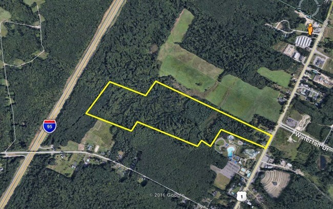
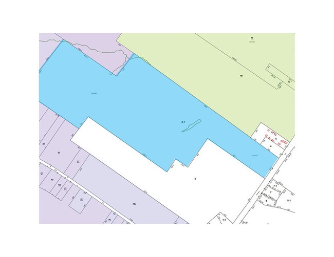
5 Merrill Dr
SACO-000063-000003-000001
YORK
Apartment
Maine
PR
3
B and X Area of moderate flood hazard, usually the area between the limits of the 100-year and 500-year floods.
65.84 AC
2025
York County
2025
Portland/South Portland
017306
Portland-South Portland, ME
522 SF
NEARBY LISTINGS FOR SALE OR LEASE
-
-
View all Saco listings for sale on LoopNet.com
DEMOGRAPHICS near 5 Merrill Dr
1 mile
3 mile
5 mile
2025 Total Population
1,500
16,633
52,516
2030 Population
1,519
17,377
54,278
Pop Growth 2025-2030
+ 1.27%
+ 4.47%
+ 3.36%
Average Age
44
47
45
2025 Total Households
697
7,666
23,488
HH Growth 2025-2030
+ 1.00%
+ 4.97%
+ 3.63%
Median Household Inc
$89,248
$87,206
$86,238
Avg Household Size
2.10
2.10
2.20
2025 Avg HH Vehicles
2.00
2.00
2.00
Median Home Value
$426,630
$450,232
$445,719
Median Year Built
1983
1985
1981
Nearby Places
Map Layers
Map Styles
 Street
 Aerial
Layers
 Traffic
 Biking
Places
Listings with unknown addresses are not visible on the map
- Restaurants
- Banks
- Shops
- Fitness
- Groceries
SALE & LEASE HISTORY
LISTING DATE
SALE/LEASE

Sep 24, 2016
For Sale
Nov 05, 2019
For Sale
Nearby Properties
Address
Land Use
TOTAL SIZE
Lot Size
Zoning
Address
Land Use
TOTAL SIZE
Lot Size
Zoning
113,025 SF
7.30 AC
31
Address
Land Use
TOTAL SIZE
Lot Size
Zoning
Address
Land Use
TOTAL SIZE
Lot Size
Zoning
124,820 SF
30.53 AC
PR
Address
Land Use
TOTAL SIZE
Lot Size
Zoning
7.86 AC
B2A
Address
Land Use
TOTAL SIZE
Lot Size
Zoning
48,887 SF
12.59 AC
I
Address
Land Use
TOTAL SIZE
Lot Size
Zoning
2.50 AC
R-1
Address
Land Use
TOTAL SIZE
Lot Size
Zoning
127,412 SF
12.55 AC
I
Address
Land Use
TOTAL SIZE
Lot Size
Zoning
104.71 AC
PR
Address
Land Use
TOTAL SIZE
Lot Size
Zoning
708 SF
52.01 AC
R-4
Address
Land Use
TOTAL SIZE
Lot Size
Zoning
5.98 AC
PR
Address
Land Use
TOTAL SIZE
Lot Size
Zoning
94,345 SF
21.28 AC
I
Address
Land Use
TOTAL SIZE
Lot Size
Zoning
19,725 SF
45.64 AC
16
Address
Land Use
TOTAL SIZE
Lot Size
Zoning
3,033 SF
55.01 AC
RD
Address
Land Use
TOTAL SIZE
Lot Size
Zoning
39,881 SF
39.79 AC
PR
Address
Land Use
TOTAL SIZE
Lot Size
Zoning
55,740 SF
7.01 AC
I
Address
Land Use
TOTAL SIZE
Lot Size
Zoning
33,888 SF
35.42 AC
I
Address
Land Use
TOTAL SIZE
Lot Size
Zoning
47,532 SF
4.76 AC
MZ
Address
Land Use
TOTAL SIZE
Lot Size
Zoning
7,216 SF
10.40 AC
MZ
Address
Land Use
TOTAL SIZE
Lot Size
Zoning
5,000 SF
8.30 AC
PMUD
Address
Land Use
TOTAL SIZE
Lot Size
Zoning
14.62 AC
31
Address
Land Use
TOTAL SIZE
Lot Size
Zoning
24,192 SF
1.80 AC
BRD
Address
Land Use
TOTAL SIZE
Lot Size
Zoning
39,344 SF
56.22 AC
PR
Address
Land Use
TOTAL SIZE
Lot Size
Zoning
45,290 SF
11.60 AC
25
Address
Land Use
TOTAL SIZE
Lot Size
Zoning
1,768 SF
21.12 AC
MZ
Address
Land Use
TOTAL SIZE
Lot Size
Zoning
80,366 SF
11.16 AC
I
Address
Land Use
TOTAL SIZE
Lot Size
Zoning
46,250 SF
2.14 AC
RBD
Address
Land Use
TOTAL SIZE
Lot Size
Zoning
35,315 SF
8.41 AC
I
Address
Land Use
TOTAL SIZE
Lot Size
Zoning
57,118 SF
10.01 AC
I
Address
Land Use
TOTAL SIZE
Lot Size
Zoning
40 AC
PR
The World's #1 Commercial Real Estate Marketplace
Connect with us
© 2026 CoStar Group
The information above has been obtained from sources believed reliable. While we do not doubt its accuracy we have not verified it and make no guarantee, warranty or representation about it. It is your responsibility to independently confirm its accuracy and completeness. Any projections, opinions, assumptions, or estimates used are for example only and do not represent the current or future performance of the property. The value of this transaction to you depends on tax and other factors which should be evaluated by your tax, financial, and legal advisors. You and your advisors should conduct a careful, independent investigation of the property to determine to your satisfaction the suitability of the property for your needs.