Property Record
5 Ponderosa Ct, Montrose, CO 81401
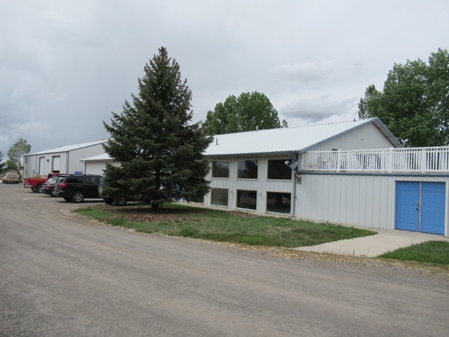

Property Detail
5 Ponderosa Ct
Montrose, CO
SUBD: BLACK CANYON INDUSTRIAL PARK REPLAT OF LOT 1 AMENDED LOT: B S: 21 T: 49 R: 9
R0652153
Montrose
Manufacturinglight
Colorado
B and X Area of moderate flood hazard, usually the area between the limits of the 100-year and 500-year floods.
1
2025
2.02 AC
2025
Colorado Southwest Area
966302
Other Market Areas
4,634 SF
NEARBY LISTINGS FOR SALE OR LEASE
-
-
View all Montrose listings for lease on LoopNet.com
DEMOGRAPHICS near 5 Ponderosa Ct
1 mile
3 mile
5 mile
2025 Total Population
3,919
23,572
32,091
2030 Population
4,126
24,681
33,616
Pop Growth 2025-2030
+ 5.28%
+ 4.70%
+ 4.75%
Average Age
40
42
44
2025 Total Households
1,623
9,907
13,414
HH Growth 2025-2030
+ 5.30%
+ 4.70%
+ 4.76%
Median Household Inc
$53,678
$66,119
$72,429
Avg Household Size
2.30
2.30
2.30
2025 Avg HH Vehicles
2.00
2.00
2.00
Median Home Value
$288,678
$338,989
$381,370
Median Year Built
1978
1990
1993
Nearby Places
Map Layers
Map Styles
 Street
 Aerial
Transit
 Traffic
 Biking
Places
Listings with unknown addresses are not visible on the map
- Restaurants
- Banks
- Shops
- Fitness
- Groceries
PUBLIC TRANSPORTATION
AIRPORT
Montrose Regional
Drive
Walk
Distance
Montrose Regional
11 min
3.7 mi
Freight Ports
Port of San Diego
Drive
Walk
Distance
Port of San Diego
950 min
897.6 mi
SALE & LEASE HISTORY
LISTING DATE
SALE/LEASE

Nov 13, 2019
For Lease
May 23, 2019
For Sale
Nearby Properties
Address
Land Use
TOTAL SIZE
Lot Size
Zoning
Address
Land Use
TOTAL SIZE
Lot Size
Zoning
229,488 SF
Address
Land Use
TOTAL SIZE
Lot Size
Zoning
104,240 SF
29.39 AC
Address
Land Use
TOTAL SIZE
Lot Size
Zoning
84,927 SF
15.45 AC
Address
Land Use
TOTAL SIZE
Lot Size
Zoning
67,223 SF
0.62 AC
Address
Land Use
TOTAL SIZE
Lot Size
Zoning
54,125 SF
18.15 AC
Address
Land Use
TOTAL SIZE
Lot Size
Zoning
93,240 SF
8.32 AC
Address
Land Use
TOTAL SIZE
Lot Size
Zoning
17,872 SF
2 AC
Address
Land Use
TOTAL SIZE
Lot Size
Zoning
52,533 SF
3.73 AC
Address
Land Use
TOTAL SIZE
Lot Size
Zoning
63,757 SF
2.14 AC
Address
Land Use
TOTAL SIZE
Lot Size
Zoning
21,000 SF
14.34 AC
Address
Land Use
TOTAL SIZE
Lot Size
Zoning
54,088 SF
79.70 AC
Address
Land Use
TOTAL SIZE
Lot Size
Zoning
9,607 SF
17.78 AC
Address
Land Use
TOTAL SIZE
Lot Size
Zoning
48,096 SF
33.43 AC
B2
Address
Land Use
TOTAL SIZE
Lot Size
Zoning
68,768 SF
7.73 AC
Address
Land Use
TOTAL SIZE
Lot Size
Zoning
51,727 SF
2.56 AC
Address
Land Use
TOTAL SIZE
Lot Size
Zoning
13,091 SF
0.86 AC
MR
Address
Land Use
TOTAL SIZE
Lot Size
Zoning
95,971 SF
4.68 AC
Address
Land Use
TOTAL SIZE
Lot Size
Zoning
33,554 SF
10 AC
Address
Land Use
TOTAL SIZE
Lot Size
Zoning
38,729 SF
3.83 AC
Address
Land Use
TOTAL SIZE
Lot Size
Zoning
97,056 SF
11.51 AC
Address
Land Use
TOTAL SIZE
Lot Size
Zoning
34,032 SF
1.56 AC
Address
Land Use
TOTAL SIZE
Lot Size
Zoning
250,620 SF
21.70 AC
Address
Land Use
TOTAL SIZE
Lot Size
Zoning
38,566 SF
2 AC
Address
Land Use
TOTAL SIZE
Lot Size
Zoning
44,918 SF
4.49 AC
Address
Land Use
TOTAL SIZE
Lot Size
Zoning
32,704 SF
7.24 AC
Address
Land Use
TOTAL SIZE
Lot Size
Zoning
55,624 SF
3.49 AC
Address
Land Use
TOTAL SIZE
Lot Size
Zoning
48,396 SF
7.94 AC
Address
Land Use
TOTAL SIZE
Lot Size
Zoning
18,441 SF
1.87 AC
Address
Land Use
TOTAL SIZE
Lot Size
Zoning
22,219 SF
6.27 AC
Address
Land Use
TOTAL SIZE
Lot Size
Zoning
34,601 SF
1.61 AC
The World's #1 Commercial Real Estate Marketplace
Connect with us
© 2026 CoStar Group
The information above has been obtained from sources believed reliable. While we do not doubt its accuracy we have not verified it and make no guarantee, warranty or representation about it. It is your responsibility to independently confirm its accuracy and completeness. Any projections, opinions, assumptions, or estimates used are for example only and do not represent the current or future performance of the property. The value of this transaction to you depends on tax and other factors which should be evaluated by your tax, financial, and legal advisors. You and your advisors should conduct a careful, independent investigation of the property to determine to your satisfaction the suitability of the property for your needs.