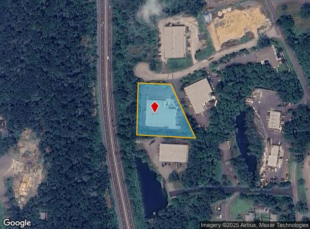
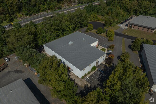
Property Record
5 Production Dr, Brookfield, CT 06804

NEARBY LISTINGS FOR SALE OR LEASE
Property Detail
5 Production Dr
BROO-000005C-000000-000014
Fairfield
Industrialgeneral
Connecticut
AE
14
09001C0131F
1.87 AC
2025
Brookfield
2025
Westchester/So Connecticut
205100
Bridgeport-Stamford-Danbury, CT
20,534 SF
DEMOGRAPHICS near 5 Production Dr
1 mile
3 mile
5 mile
2024 Total Population
2,293
18,059
50,318
2029 Population
2,310
18,338
50,892
Pop Growth 2024-2029
+ 0.74%
+ 1.54%
+ 1.14%
Average Age
43
43
43
2024 Total Households
897
6,890
18,934
HH Growth 2024-2029
+ 0.78%
+ 1.57%
+ 1.14%
Median Household Inc
$118,235
$122,765
$118,057
Avg Household Size
2.60
2.60
2.50
2024 Avg HH Vehicles
2.00
2.00
2.00
Median Home Value
$406,218
$420,274
$392,694
Median Year Built
1971
1971
1974
Nearby Places
Map Layers
Map Styles
 Street
 Aerial
Transit
 Traffic
 Biking
Places
Listings with unknown addresses are not visible on the map
- Restaurants
- Banks
- Shops
- Fitness
- Groceries
PUBLIC TRANSPORTATION
COMMUTER RAIL
Danbury Station (New Haven Line - Metro-North Commuter Railroad Company (Metro-North))
Drive
Walk
Distance
Danbury Station (New Haven Line - Metro-North Commuter Railroad Company (Metro-North))
17 min
9.4 mi
AIRPORT
Tweed/New Haven
Drive
Walk
Distance
Tweed/New Haven
65 min
38.8 mi
Westchester County
Drive
Walk
Distance
Westchester County
57 min
43.2 mi
Freight Ports
Port of New Haven
Drive
Walk
Distance
Port of New Haven
59 min
36.6 mi
SALE & LEASE HISTORY
LISTING DATE
SALE/LEASE

Sep 07, 2018
For Lease
May 29, 2020
For Lease
Nearby Properties
Address
Land Use
TOTAL SIZE
Lot Size
Zoning
Address
Land Use
TOTAL SIZE
Lot Size
Zoning
45.66 AC
IC/R40
Address
Land Use
TOTAL SIZE
Lot Size
Zoning
168,282 SF
22.83 AC
R-60
Address
Land Use
TOTAL SIZE
Lot Size
Zoning
79.31 AC
R-80
Address
Land Use
TOTAL SIZE
Lot Size
Zoning
9.39 AC
C-2
Address
Land Use
TOTAL SIZE
Lot Size
Zoning
45.15 AC
I-1 HO
Address
Land Use
TOTAL SIZE
Lot Size
Zoning
5,658 SF
20.10 AC
RR3
Address
Land Use
TOTAL SIZE
Lot Size
Zoning
77,492 SF
30.25 AC
Address
Land Use
TOTAL SIZE
Lot Size
Zoning
2,173 SF
4.76 AC
TCD
Address
Land Use
TOTAL SIZE
Lot Size
Zoning
53,582 SF
7.71 AC
C-2
Address
Land Use
TOTAL SIZE
Lot Size
Zoning
2,295.68 AC
Address
Land Use
TOTAL SIZE
Lot Size
Zoning
6.54 AC
TCD-P
Address
Land Use
TOTAL SIZE
Lot Size
Zoning
151,200 SF
12.48 AC
I-1
Address
Land Use
TOTAL SIZE
Lot Size
Zoning
110,200 SF
4.96 AC
I-1 HO
Address
Land Use
TOTAL SIZE
Lot Size
Zoning
9.29 AC
R-60
Address
Land Use
TOTAL SIZE
Lot Size
Zoning
57,782 SF
7.14 AC
R-80
Address
Land Use
TOTAL SIZE
Lot Size
Zoning
54.60 AC
R-80
Address
Land Use
TOTAL SIZE
Lot Size
Zoning
4.65 AC
TCD
Address
Land Use
TOTAL SIZE
Lot Size
Zoning
60,042 SF
7.20 AC
TCD
Address
Land Use
TOTAL SIZE
Lot Size
Zoning
29,862 SF
1.41 AC
TCD
Address
Land Use
TOTAL SIZE
Lot Size
Zoning
10.07 AC
I-1
Address
Land Use
TOTAL SIZE
Lot Size
Zoning
4.80 AC
I-1
Address
Land Use
TOTAL SIZE
Lot Size
Zoning
99,524 SF
9.41 AC
I-1
Address
Land Use
TOTAL SIZE
Lot Size
Zoning
2,400 SF
1,190.70 AC
R80
Address
Land Use
TOTAL SIZE
Lot Size
Zoning
1.92 AC
MC
Address
Land Use
TOTAL SIZE
Lot Size
Zoning
4,915 SF
4.08 AC
1
Address
Land Use
TOTAL SIZE
Lot Size
Zoning
36,239 SF
5.93 AC
C-2
Address
Land Use
TOTAL SIZE
Lot Size
Zoning
9,541 SF
3.02 AC
RR3
Address
Land Use
TOTAL SIZE
Lot Size
Zoning
7,727 SF
24.64 AC
1
Address
Land Use
TOTAL SIZE
Lot Size
Zoning
22,832 SF
9.70 AC
R-40
Address
Land Use
TOTAL SIZE
Lot Size
Zoning
4.01 AC
I-C
The World's #1 Commercial Real Estate Marketplace
Connect with us
© 2026 CoStar Group
The information above has been obtained from sources believed reliable. While we do not doubt its accuracy we have not verified it and make no guarantee, warranty or representation about it. It is your responsibility to independently confirm its accuracy and completeness. Any projections, opinions, assumptions, or estimates used are for example only and do not represent the current or future performance of the property. The value of this transaction to you depends on tax and other factors which should be evaluated by your tax, financial, and legal advisors. You and your advisors should conduct a careful, independent investigation of the property to determine to your satisfaction the suitability of the property for your needs.