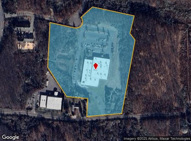
Property Record
56 Carpenter Ln, Wallingford, CT 06492

NEARBY LISTINGS FOR SALE OR LEASE
Property Detail
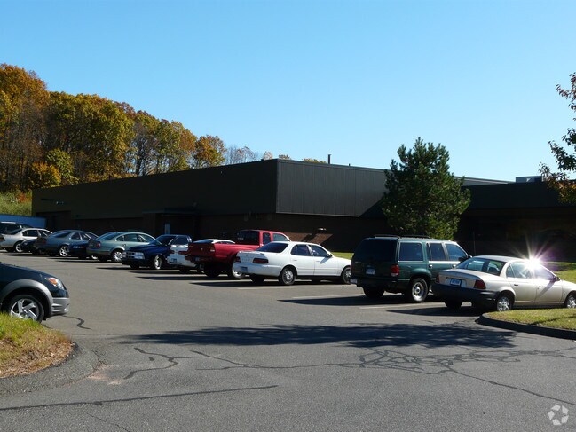
56 Carpenter Ln
WALL-000055-000000-000007
New Haven
Scientificpharmaceuticalmedicalresearchfacility
Connecticut
X
7
09009C0307J
14.02 AC
2025
Wallingford
2025
Westchester/So Connecticut
176000
New Haven, CT
52,668 SF
DEMOGRAPHICS near 56 Carpenter Ln
1 mile
3 mile
5 mile
2024 Total Population
634
20,625
99,997
2029 Population
630
20,501
99,468
Pop Growth 2024-2029
(0.63%)
(0.60%)
(0.53%)
Average Age
43
43
41
2024 Total Households
223
8,095
40,152
HH Growth 2024-2029
(0.90%)
(0.77%)
(0.60%)
Median Household Inc
$133,500
$96,981
$74,812
Avg Household Size
2.70
2.40
2.40
2024 Avg HH Vehicles
3.00
2.00
2.00
Median Home Value
$370,329
$274,427
$246,353
Median Year Built
1981
1974
1962
Nearby Places
Map Layers
Map Styles
 Street
 Aerial
Transit
 Traffic
 Biking
Places
Listings with unknown addresses are not visible on the map
- Restaurants
- Banks
- Shops
- Fitness
- Groceries
PUBLIC TRANSPORTATION
COMMUTER RAIL
Drive
Walk
Distance
10 min
5.1 mi
Drive
Walk
Distance
11 min
5.3 mi
AIRPORT
Tweed/New Haven
Drive
Walk
Distance
Tweed/New Haven
32 min
20.3 mi
Bradley International
Drive
Walk
Distance
Bradley International
61 min
38.8 mi
SALE & LEASE HISTORY
LISTING DATE
SALE/LEASE

May 02, 2019
For Sale
Nearby Properties
Address
Land Use
TOTAL SIZE
Lot Size
Zoning
Address
Land Use
TOTAL SIZE
Lot Size
Zoning
267,249 SF
27.55 AC
R-1
Address
Land Use
TOTAL SIZE
Lot Size
Zoning
10.38 AC
M-1
Address
Land Use
TOTAL SIZE
Lot Size
Zoning
329,296 SF
35.55 AC
IX
Address
Land Use
TOTAL SIZE
Lot Size
Zoning
291,405 SF
104.81 AC
WI
Address
Land Use
TOTAL SIZE
Lot Size
Zoning
119,598 SF
18.43 AC
RF40
Address
Land Use
TOTAL SIZE
Lot Size
Zoning
11.02 AC
S-R
Address
Land Use
TOTAL SIZE
Lot Size
Zoning
172,027 SF
18.04 AC
RF40
Address
Land Use
TOTAL SIZE
Lot Size
Zoning
26.45 AC
RF40
Address
Land Use
TOTAL SIZE
Lot Size
Zoning
187,914 SF
16.13 AC
IX
Address
Land Use
TOTAL SIZE
Lot Size
Zoning
203,692 SF
21.22 AC
IX
Address
Land Use
TOTAL SIZE
Lot Size
Zoning
22,284 SF
128.20 AC
RU40
Address
Land Use
TOTAL SIZE
Lot Size
Zoning
18.70 AC
RF40
Address
Land Use
TOTAL SIZE
Lot Size
Zoning
166,724 SF
21.79 AC
M-2
Address
Land Use
TOTAL SIZE
Lot Size
Zoning
9.75 AC
RF40
Address
Land Use
TOTAL SIZE
Lot Size
Zoning
598.20 AC
R-R
Address
Land Use
TOTAL SIZE
Lot Size
Zoning
48,942 SF
6.74 AC
RF40
Address
Land Use
TOTAL SIZE
Lot Size
Zoning
19.47 AC
RF40
Address
Land Use
TOTAL SIZE
Lot Size
Zoning
81,496 SF
5.96 AC
WI
Address
Land Use
TOTAL SIZE
Lot Size
Zoning
94,044 SF
5.48 AC
WI
Address
Land Use
TOTAL SIZE
Lot Size
Zoning
20,330 SF
174.02 AC
WI
Address
Land Use
TOTAL SIZE
Lot Size
Zoning
115,951 SF
14.77 AC
M-1
Address
Land Use
TOTAL SIZE
Lot Size
Zoning
98,894 SF
44.82 AC
WI
Address
Land Use
TOTAL SIZE
Lot Size
Zoning
18.61 AC
C-2
Address
Land Use
TOTAL SIZE
Lot Size
Zoning
173,063 SF
22.38 AC
IX
Address
Land Use
TOTAL SIZE
Lot Size
Zoning
78,477 SF
5 AC
WI
Address
Land Use
TOTAL SIZE
Lot Size
Zoning
125,420 SF
6.79 AC
R-1
Address
Land Use
TOTAL SIZE
Lot Size
Zoning
134,456 SF
25.84 AC
IX
Address
Land Use
TOTAL SIZE
Lot Size
Zoning
332,064 SF
34.36 AC
RF40
Address
Land Use
TOTAL SIZE
Lot Size
Zoning
16.80 AC
I40
Address
Land Use
TOTAL SIZE
Lot Size
Zoning
13.62 AC
RF40
The World's #1 Commercial Real Estate Marketplace
Connect with us
© 2026 CoStar Group
The information above has been obtained from sources believed reliable. While we do not doubt its accuracy we have not verified it and make no guarantee, warranty or representation about it. It is your responsibility to independently confirm its accuracy and completeness. Any projections, opinions, assumptions, or estimates used are for example only and do not represent the current or future performance of the property. The value of this transaction to you depends on tax and other factors which should be evaluated by your tax, financial, and legal advisors. You and your advisors should conduct a careful, independent investigation of the property to determine to your satisfaction the suitability of the property for your needs.