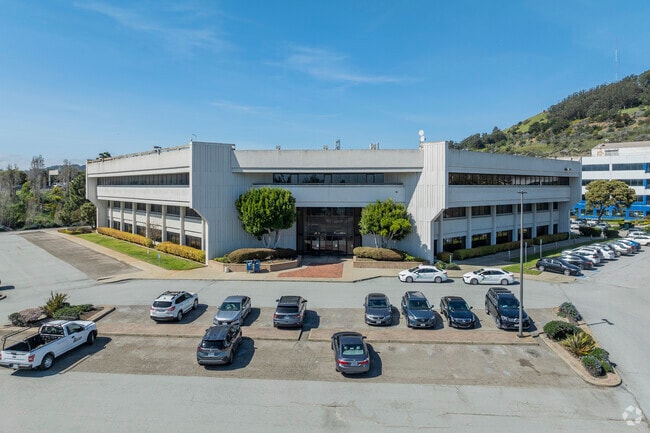
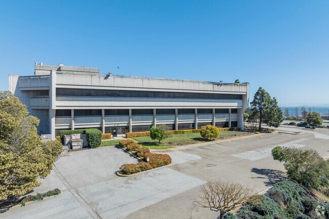
Property Record
5 Thomas Mellon Cir, San Francisco, CA 94134

NEARBY LISTINGS FOR SALE OR LEASE
Property Detail
5 Thomas Mellon Cir
San Francisco-Redwood City-South San Francisco, CA
Executive Park
4991-075
San Francisco
Residentialacreage
California
2024
75
2025
4.45 AC
061000
Bayview/Hunters Point
100,393 SF
San Francisco
DEMOGRAPHICS near 5 Thomas Mellon Cir
1 Mile
3 Mile
5 Mile
2024 Total Population
19,267
159,673
512,742
2029 Population
17,440
145,406
475,161
Pop Growth 2024-2029
(9.48%)
(8.94%)
(7.33%)
Average Age
42
42
42
2024 Total Households
5,369
49,966
191,304
HH Growth 2024-2029
(10.09%)
(9.32%)
(7.64%)
Median Household Inc
$86,572
$109,973
$125,557
Avg Household Size
3.30
3.00
2.50
2024 Avg HH Vehicles
2.00
2.00
1.00
Median Home Value
$891,588
$1,054,022
$1,075,586
Median Year Built
1959
1951
1955
Nearby Places
Map Layers
Map Styles
 Street
 Aerial
- Restaurants
- Banks
- Shops
- Fitness
- Groceries
PUBLIC TRANSPORTATION
TRANSIT/SUBWAY
Arleta Station (T Third Street - San Francisco Municipal Railway (MUNI Metro), THIRD - San Francisco Municipal Railway (MUNI Metro))
DRIVE
WALK
Distance
Arleta Station (T Third Street - San Francisco Municipal Railway (MUNI Metro), THIRD - San Francisco Municipal Railway (MUNI Metro))
3 min
12 min
0.6 mi
Bayshore Blvd & Sunnydale Ave (THIRD - San Francisco Municipal Transportation Agency)
DRIVE
WALK
Distance
Bayshore Blvd & Sunnydale Ave (THIRD - San Francisco Municipal Transportation Agency)
3 min
17 min
0.9 mi
Sunnydale Station (T Third Street - San Francisco Municipal Railway (MUNI Metro))
DRIVE
WALK
Distance
Sunnydale Station (T Third Street - San Francisco Municipal Railway (MUNI Metro))
2 min
18 min
0.9 mi
Third Street & Le Conte Ave (THIRD - San Francisco Municipal Transportation Agency)
DRIVE
WALK
Distance
Third Street & Le Conte Ave (THIRD - San Francisco Municipal Transportation Agency)
2 min
20 min
1.1 mi
Le Conte Station (T Third Street - San Francisco Municipal Railway (MUNI Metro))
DRIVE
WALK
Distance
Le Conte Station (T Third Street - San Francisco Municipal Railway (MUNI Metro))
2 min
20 min
1.1 mi
COMMUTER RAIL
Bayshore Caltrain Station (Local - Caltrain (Caltrain), Local Weekday - Caltrain (Caltrain), Local Weekend - Caltrain (Caltrain))
DRIVE
WALK
Distance
Bayshore Caltrain Station (Local - Caltrain (Caltrain), Local Weekday - Caltrain (Caltrain), Local Weekend - Caltrain (Caltrain))
2 min
14 min
0.7 mi
22Nd Street (Caltrain - Caltrain (Caltrain))
DRIVE
WALK
Distance
22Nd Street (Caltrain - Caltrain (Caltrain))
8 min
5.5 mi
AIRPORT
San Francisco International
DRIVE
WALK
Distance
San Francisco International
13 min
8.1 mi
Metro Oakland International
DRIVE
WALK
Distance
Metro Oakland International
36 min
24.9 mi
Freight Ports
Port of San Francisco
DRIVE
WALK
Distance
Port of San Francisco
13 min
7.7 mi
SALE & LEASE HISTORY
LISTING DATE
SALE/LEASE

Sep 24, 2016
For Lease
Nearby Properties
Address
Land Use
TOTAL SIZE
Lot Size
Zoning
Address
Land Use
TOTAL SIZE
Lot Size
Zoning
248,303 SF
4.35 AC
Address
Land Use
TOTAL SIZE
Lot Size
Zoning
8.97 AC
OA0000
Address
Land Use
TOTAL SIZE
Lot Size
Zoning
350,036 SF
2.91 AC
Address
Land Use
TOTAL SIZE
Lot Size
Zoning
Address
Land Use
TOTAL SIZE
Lot Size
Zoning
Address
Land Use
TOTAL SIZE
Lot Size
Zoning
346,710 SF
7.45 AC
RH2
Address
Land Use
TOTAL SIZE
Lot Size
Zoning
141,360 SF
8.56 AC
Address
Land Use
TOTAL SIZE
Lot Size
Zoning
141,677 SF
8.57 AC
Address
Land Use
TOTAL SIZE
Lot Size
Zoning
226,606 SF
10.20 AC
OA0000
Address
Land Use
TOTAL SIZE
Lot Size
Zoning
54,000 SF
1.67 AC
PDR2
Address
Land Use
TOTAL SIZE
Lot Size
Zoning
439,294 SF
5.43 AC
PDR2
Address
Land Use
TOTAL SIZE
Lot Size
Zoning
201,793 SF
5.66 AC
OA0000
Address
Land Use
TOTAL SIZE
Lot Size
Zoning
Address
Land Use
TOTAL SIZE
Lot Size
Zoning
143,920 SF
7.29 AC
PDR2
Address
Land Use
TOTAL SIZE
Lot Size
Zoning
183,284 SF
6.85 AC
PD0000
Address
Land Use
TOTAL SIZE
Lot Size
Zoning
90,828 SF
2.41 AC
Address
Land Use
TOTAL SIZE
Lot Size
Zoning
28,300 SF
4.94 AC
M2
Address
Land Use
TOTAL SIZE
Lot Size
Zoning
100,655 SF
4.56 AC
Address
Land Use
TOTAL SIZE
Lot Size
Zoning
13,200 SF
3.54 AC
PDR2
Address
Land Use
TOTAL SIZE
Lot Size
Zoning
2,001 SF
6.92 AC
Address
Land Use
TOTAL SIZE
Lot Size
Zoning
268,042 SF
15.01 AC
A00000
Address
Land Use
TOTAL SIZE
Lot Size
Zoning
1.33 AC
M1
Address
Land Use
TOTAL SIZE
Lot Size
Zoning
31,400 SF
2.76 AC
PDR2
Address
Land Use
TOTAL SIZE
Lot Size
Zoning
279,560 SF
13.24 AC
M10000
Address
Land Use
TOTAL SIZE
Lot Size
Zoning
160,000 SF
1.27 AC
C2
Address
Land Use
TOTAL SIZE
Lot Size
Zoning
95,469 SF
3.68 AC
RH-1
Address
Land Use
TOTAL SIZE
Lot Size
Zoning
12,555 SF
0.74 AC
NCS
Address
Land Use
TOTAL SIZE
Lot Size
Zoning
3.77 AC
Address
Land Use
TOTAL SIZE
Lot Size
Zoning
2.62 AC
RH1
Address
Land Use
TOTAL SIZE
Lot Size
Zoning
6.87 AC
RH2
The World's #1 Commercial Real Estate Marketplace
Connect with us
© 2026 CoStar Group
The information above has been obtained from sources believed reliable. While we do not doubt its accuracy we have not verified it and make no guarantee, warranty or representation about it. It is your responsibility to independently confirm its accuracy and completeness. Any projections, opinions, assumptions, or estimates used are for example only and do not represent the current or future performance of the property. The value of this transaction to you depends on tax and other factors which should be evaluated by your tax, financial, and legal advisors. You and your advisors should conduct a careful, independent investigation of the property to determine to your satisfaction the suitability of the property for your needs.