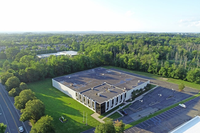
Property Record
5 Vreeland Rd, Florham Park, NJ 07932

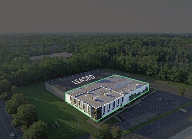
Current Lease Availabilities
NEARBY LISTINGS FOR SALE OR LEASE
Property Detail
5 Vreeland Rd
Newark, NJ-PA
Florham Park Industrial Mall
11-00301-0000-00005
Morris
Industrialgeneral
New Jersey
AE
5
34013C0086G
5.01 AC
2024
Morristown Region
2025
Northern New Jersey
042602
DEMOGRAPHICS near 5 Vreeland Rd
1 Mile
3 Mile
5 Mile
2024 Total Population
4,236
46,701
153,353
2029 Population
4,219
46,544
153,004
Pop Growth 2024-2029
(0.40%)
(0.34%)
(0.23%)
Average Age
46
43
42
2024 Total Households
1,692
16,411
53,882
HH Growth 2024-2029
(0.59%)
(0.44%)
(0.32%)
Median Household Inc
$139,209
$148,720
$159,389
Avg Household Size
2.50
2.80
2.70
2024 Avg HH Vehicles
2.00
2.00
2.00
Median Home Value
$687,054
$713,972
$748,301
Median Year Built
1983
1969
1966
Nearby Places
Map Layers
Map Styles
 Street
 Aerial
- Restaurants
- Banks
- Shops
- Fitness
- Groceries
PUBLIC TRANSPORTATION
COMMUTER RAIL
Madison (Morris & Essex Morristown Line - NJ Transit Commuter Rail (NJ Transit))
DRIVE
WALK
Distance
Madison (Morris & Essex Morristown Line - NJ Transit Commuter Rail (NJ Transit))
11 min
4.1 mi
Chatham (Morris & Essex Morristown Line - NJ Transit Commuter Rail (NJ Transit))
DRIVE
WALK
Distance
Chatham (Morris & Essex Morristown Line - NJ Transit Commuter Rail (NJ Transit))
12 min
5.4 mi
AIRPORT
Newark Liberty International
DRIVE
WALK
Distance
Newark Liberty International
29 min
19.0 mi
LaGuardia
DRIVE
WALK
Distance
LaGuardia
62 min
41.5 mi
John F Kennedy International
DRIVE
WALK
Distance
John F Kennedy International
73 min
44.8 mi
Freight Ports
Maher Terminal
DRIVE
WALK
Distance
Maher Terminal
33 min
19.6 mi
Nearby Properties
Address
Land Use
TOTAL SIZE
Lot Size
Zoning
Address
Land Use
TOTAL SIZE
Lot Size
Zoning
701 SF
111.59 AC
SED
Address
Land Use
TOTAL SIZE
Lot Size
Zoning
64.30 AC
MF-4
Address
Land Use
TOTAL SIZE
Lot Size
Zoning
48.76 AC
OBRL
Address
Land Use
TOTAL SIZE
Lot Size
Zoning
37.70 AC
R-6
Address
Land Use
TOTAL SIZE
Lot Size
Zoning
64.80 AC
C-4
Address
Land Use
TOTAL SIZE
Lot Size
Zoning
42.64 AC
D-S
Address
Land Use
TOTAL SIZE
Lot Size
Zoning
9.80 AC
Address
Land Use
TOTAL SIZE
Lot Size
Zoning
31.03 AC
R-L
Address
Land Use
TOTAL SIZE
Lot Size
Zoning
41.19 AC
MF-C
Address
Land Use
TOTAL SIZE
Lot Size
Zoning
43.60 AC
C-4
Address
Land Use
TOTAL SIZE
Lot Size
Zoning
59,369 SF
86.79 AC
R-44
Address
Land Use
TOTAL SIZE
Lot Size
Zoning
18.98 AC
R-5B
Address
Land Use
TOTAL SIZE
Lot Size
Zoning
19.70 AC
R-4
Address
Land Use
TOTAL SIZE
Lot Size
Zoning
13.10 AC
R-25
Address
Land Use
TOTAL SIZE
Lot Size
Zoning
27.20 AC
PODS
Address
Land Use
TOTAL SIZE
Lot Size
Zoning
17.26 AC
R-L
Address
Land Use
TOTAL SIZE
Lot Size
Zoning
20.97 AC
R-2
Address
Land Use
TOTAL SIZE
Lot Size
Zoning
60 AC
R-L
Address
Land Use
TOTAL SIZE
Lot Size
Zoning
46.46 AC
B-3
Address
Land Use
TOTAL SIZE
Lot Size
Zoning
55.22 AC
R-2
Address
Land Use
TOTAL SIZE
Lot Size
Zoning
58.20 AC
I
Address
Land Use
TOTAL SIZE
Lot Size
Zoning
336,832 SF
46.12 AC
R-L
Address
Land Use
TOTAL SIZE
Lot Size
Zoning
35.55 AC
P-B2
Address
Land Use
TOTAL SIZE
Lot Size
Zoning
15.50 AC
R-1
Address
Land Use
TOTAL SIZE
Lot Size
Zoning
252,828 SF
44.53 AC
C-1
Address
Land Use
TOTAL SIZE
Lot Size
Zoning
40.90 AC
MF-4
Address
Land Use
TOTAL SIZE
Lot Size
Zoning
49.53 AC
P
Address
Land Use
TOTAL SIZE
Lot Size
Zoning
25.40 AC
I-3
Address
Land Use
TOTAL SIZE
Lot Size
Zoning
5.35 AC
MF-6
Address
Land Use
TOTAL SIZE
Lot Size
Zoning
The World's #1 Commercial Real Estate Marketplace
Connect with us
© 2026 CoStar Group
The information above has been obtained from sources believed reliable. While we do not doubt its accuracy we have not verified it and make no guarantee, warranty or representation about it. It is your responsibility to independently confirm its accuracy and completeness. Any projections, opinions, assumptions, or estimates used are for example only and do not represent the current or future performance of the property. The value of this transaction to you depends on tax and other factors which should be evaluated by your tax, financial, and legal advisors. You and your advisors should conduct a careful, independent investigation of the property to determine to your satisfaction the suitability of the property for your needs.