Property Record
5 Walnut St, Agawam, MA 01001


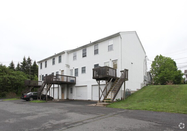
Property Detail
5 Walnut St
AGAW-000017I-000012-000006
Hampden
Apartment
Massachusetts
A3
6
AE The base floodplain where base flood elevations are provided. AE Zones are now used on new format FIRMs instead of A1-A30 Zones.
0.36 AC
2025
West Hampden County
2025
Hartford
813207
Springfield, MA
NEARBY LISTINGS FOR SALE OR LEASE
DEMOGRAPHICS near 5 Walnut St
1 mile
3 mile
5 mile
2025 Total Population
11,158
71,309
182,771
2030 Population
11,139
71,019
181,943
Pop Growth 2025-2030
(0.17%)
(0.41%)
(0.45%)
Average Age
40
40
39
2025 Total Households
4,850
29,885
71,315
HH Growth 2025-2030
(0.16%)
(0.35%)
(0.48%)
Median Household Inc
$56,505
$50,598
$56,414
Avg Household Size
2.20
2.30
2.40
2025 Avg HH Vehicles
1.00
1.00
1.00
Median Home Value
$269,988
$314,342
$296,512
Median Year Built
1952
1955
1951
Nearby Places
Map Layers
Map Styles
 Street
 Aerial
Layers
 Traffic
 Biking
Places
Listings with unknown addresses are not visible on the map
- Restaurants
- Banks
- Shops
- Fitness
- Groceries
PUBLIC TRANSPORTATION
COMMUTER RAIL
Springfield (Hartford Line - CONN DOT)
Drive
Walk
Distance
Springfield (Hartford Line - CONN DOT)
6 min
3.5 mi
Holyoke Amtrak (Valley Flyer - Amtrak, Vermonter - Amtrak)
Drive
Walk
Distance
Holyoke Amtrak (Valley Flyer - Amtrak, Vermonter - Amtrak)
16 min
9.7 mi
AIRPORT
Bradley International
Drive
Walk
Distance
Bradley International
29 min
12.4 mi
Freight Ports
Port of New Haven
Drive
Walk
Distance
Port of New Haven
87 min
67.1 mi
Nearby Properties
Address
Land Use
TOTAL SIZE
Lot Size
Zoning
Address
Land Use
TOTAL SIZE
Lot Size
Zoning
209,471 SF
2.98 AC
SR3C1
Address
Land Use
TOTAL SIZE
Lot Size
Zoning
247,375 SF
19.52 AC
B2
Address
Land Use
TOTAL SIZE
Lot Size
Zoning
257,525 SF
64.03 AC
Address
Land Use
TOTAL SIZE
Lot Size
Zoning
112,378 SF
3.03 AC
R2
Address
Land Use
TOTAL SIZE
Lot Size
Zoning
261,176 SF
33.36 AC
Address
Land Use
TOTAL SIZE
Lot Size
Zoning
82,248 SF
4.57 AC
SR3C1
Address
Land Use
TOTAL SIZE
Lot Size
Zoning
227,072 SF
4.37 AC
B3
Address
Land Use
TOTAL SIZE
Lot Size
Zoning
839,347 SF
2.05 AC
B3
Address
Land Use
TOTAL SIZE
Lot Size
Zoning
200,000 SF
13.91 AC
R3
Address
Land Use
TOTAL SIZE
Lot Size
Zoning
100,000 SF
17.80 AC
WC
Address
Land Use
TOTAL SIZE
Lot Size
Zoning
236,032 SF
41.65 AC
RA2
Address
Land Use
TOTAL SIZE
Lot Size
Zoning
115,600 SF
4.25 AC
B2
Address
Land Use
TOTAL SIZE
Lot Size
Zoning
24,835 SF
2.16 AC
B3
Address
Land Use
TOTAL SIZE
Lot Size
Zoning
36.60 AC
SR2C1
Address
Land Use
TOTAL SIZE
Lot Size
Zoning
201,800 SF
6.27 AC
R5
Address
Land Use
TOTAL SIZE
Lot Size
Zoning
335,105 SF
1.28 AC
B3
Address
Land Use
TOTAL SIZE
Lot Size
Zoning
186,700 SF
11.17 AC
SR3R5
Address
Land Use
TOTAL SIZE
Lot Size
Zoning
60,620 SF
4.96 AC
SR3B1
Address
Land Use
TOTAL SIZE
Lot Size
Zoning
217,116 SF
2.75 AC
R5
Address
Land Use
TOTAL SIZE
Lot Size
Zoning
77,012 SF
1.29 AC
B3
Address
Land Use
TOTAL SIZE
Lot Size
Zoning
102,787 SF
7.38 AC
I2
Address
Land Use
TOTAL SIZE
Lot Size
Zoning
137,450 SF
16 AC
Address
Land Use
TOTAL SIZE
Lot Size
Zoning
128,877 SF
28.75 AC
Address
Land Use
TOTAL SIZE
Lot Size
Zoning
57,593 SF
2.15 AC
SR3C1
Address
Land Use
TOTAL SIZE
Lot Size
Zoning
9.80 AC
101
Address
Land Use
TOTAL SIZE
Lot Size
Zoning
184,850 SF
2.39 AC
B3
Address
Land Use
TOTAL SIZE
Lot Size
Zoning
229,164 SF
3.80 AC
R5
Address
Land Use
TOTAL SIZE
Lot Size
Zoning
106,660 SF
3.37 AC
I2
Address
Land Use
TOTAL SIZE
Lot Size
Zoning
73,904 SF
4.51 AC
I2
Address
Land Use
TOTAL SIZE
Lot Size
Zoning
426,795 SF
3.99 AC
B3
The World's #1 Commercial Real Estate Marketplace
Connect with us
© 2026 CoStar Group
The information above has been obtained from sources believed reliable. While we do not doubt its accuracy we have not verified it and make no guarantee, warranty or representation about it. It is your responsibility to independently confirm its accuracy and completeness. Any projections, opinions, assumptions, or estimates used are for example only and do not represent the current or future performance of the property. The value of this transaction to you depends on tax and other factors which should be evaluated by your tax, financial, and legal advisors. You and your advisors should conduct a careful, independent investigation of the property to determine to your satisfaction the suitability of the property for your needs.