Property Record
5 Wickers Dr, Wolfeboro, NH 03894
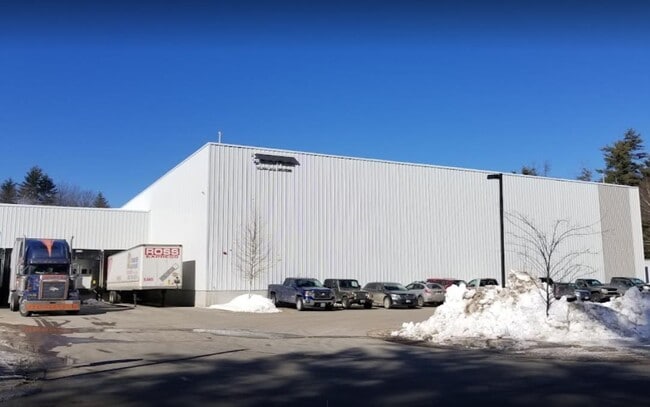

This Property Is For Sale
Property Detail
5 Wickers Dr
Industrialgeneral
Carroll
COMMER
New Hampshire
B and X Area of moderate flood hazard, usually the area between the limits of the 100-year and 500-year floods.
8.86 AC
2025
Concord/New Hampshire North Area
2025
Other Market Areas
956101
WOLF-000161-000013
99,705 SF
NEARBY LISTINGS FOR SALE OR LEASE
-
-
View all Wolfeboro listings for sale on LoopNet.com
DEMOGRAPHICS near 5 Wickers Dr
1 mile
3 mile
5 mile
2025 Total Population
884
4,769
8,302
2030 Population
906
4,888
8,472
Pop Growth 2025-2030
+ 2.49%
+ 2.50%
+ 2.05%
Average Age
51
52
51
2025 Total Households
390
2,211
3,755
HH Growth 2025-2030
+ 2.56%
+ 2.58%
+ 2.10%
Median Household Inc
$82,561
$88,513
$92,256
Avg Household Size
2.10
2.10
2.10
2025 Avg HH Vehicles
1.00
2.00
2.00
Median Home Value
$272,631
$573,376
$555,472
Median Year Built
1984
1981
1980
Nearby Places
Map Layers
Map Styles
 Street
 Aerial
Layers
 Traffic
 Biking
Places
Listings with unknown addresses are not visible on the map
- Restaurants
- Banks
- Shops
- Fitness
- Groceries
Nearby Properties
Address
Land Use
TOTAL SIZE
Lot Size
Zoning
Address
Land Use
TOTAL SIZE
Lot Size
Zoning
53,306 SF
65.72 AC
WINNIP
Address
Land Use
TOTAL SIZE
Lot Size
Zoning
306,273 SF
46.12 AC
COMMER
Address
Land Use
TOTAL SIZE
Lot Size
Zoning
17.55 AC
COMMER
Address
Land Use
TOTAL SIZE
Lot Size
Zoning
1,789 SF
30.81 AC
COMMER
Address
Land Use
TOTAL SIZE
Lot Size
Zoning
18,772 SF
5.93 AC
WINNIP
Address
Land Use
TOTAL SIZE
Lot Size
Zoning
3,578 SF
78.19 AC
COMMER
Address
Land Use
TOTAL SIZE
Lot Size
Zoning
18,179 SF
3.50 AC
WINNIP
Address
Land Use
TOTAL SIZE
Lot Size
Zoning
16,014 SF
6.20 AC
WINNIP
Address
Land Use
TOTAL SIZE
Lot Size
Zoning
3,085 SF
2.20 AC
WINNIP
Address
Land Use
TOTAL SIZE
Lot Size
Zoning
11,121 SF
1.24 AC
WINNIP
Address
Land Use
TOTAL SIZE
Lot Size
Zoning
40,404 SF
2.52 AC
WINNIP
Address
Land Use
TOTAL SIZE
Lot Size
Zoning
8,586 SF
1.63 AC
WINNIP
Address
Land Use
TOTAL SIZE
Lot Size
Zoning
2,806 SF
28.24 AC
WINNIP
Address
Land Use
TOTAL SIZE
Lot Size
Zoning
1.40 AC
WINNIP
Address
Land Use
TOTAL SIZE
Lot Size
Zoning
8,250 SF
2.70 AC
WINNIP
Address
Land Use
TOTAL SIZE
Lot Size
Zoning
9,384 SF
1.10 AC
WINNIP
Address
Land Use
TOTAL SIZE
Lot Size
Zoning
8,535 SF
1.94 AC
WINNIP
Address
Land Use
TOTAL SIZE
Lot Size
Zoning
8,058 SF
1.95 AC
WINNIP
Address
Land Use
TOTAL SIZE
Lot Size
Zoning
8,371 SF
3.10 AC
WINNIP
Address
Land Use
TOTAL SIZE
Lot Size
Zoning
7,491 SF
3.45 AC
WINNIP
Address
Land Use
TOTAL SIZE
Lot Size
Zoning
2,336 SF
2.12 AC
WINNIP
Address
Land Use
TOTAL SIZE
Lot Size
Zoning
7,873 SF
15.75 AC
WINNIP
Address
Land Use
TOTAL SIZE
Lot Size
Zoning
56 AC
ISC-IS
Address
Land Use
TOTAL SIZE
Lot Size
Zoning
5,846 SF
0.73 AC
WINNIP
Address
Land Use
TOTAL SIZE
Lot Size
Zoning
6,302 SF
7.71 AC
WINNIP
Address
Land Use
TOTAL SIZE
Lot Size
Zoning
9,682 SF
1.42 AC
WINNIP
Address
Land Use
TOTAL SIZE
Lot Size
Zoning
7,558 SF
7.30 AC
CRESCE
Address
Land Use
TOTAL SIZE
Lot Size
Zoning
8,560 SF
0.76 AC
WINNIP
Address
Land Use
TOTAL SIZE
Lot Size
Zoning
6,549 SF
3.80 AC
WINNIP
Address
Land Use
TOTAL SIZE
Lot Size
Zoning
6,616 SF
3.60 AC
WINNIP
The World's #1 Commercial Real Estate Marketplace
Connect with us
© 2026 CoStar Group
The information above has been obtained from sources believed reliable. While we do not doubt its accuracy we have not verified it and make no guarantee, warranty or representation about it. It is your responsibility to independently confirm its accuracy and completeness. Any projections, opinions, assumptions, or estimates used are for example only and do not represent the current or future performance of the property. The value of this transaction to you depends on tax and other factors which should be evaluated by your tax, financial, and legal advisors. You and your advisors should conduct a careful, independent investigation of the property to determine to your satisfaction the suitability of the property for your needs.