Property Record
7050 Garrett Rd, Upper Darby, PA 19082
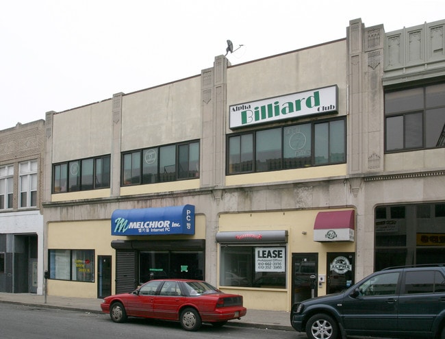
This Property Is For Sale
NEARBY LISTINGS FOR SALE OR LEASE
Property Detail
7050 Garrett Rd
16-03-00582-00
2STY BLDG STORES/OFFICES 55 X 106
Restaurantbuilding
Delaware
X
Pennsylvania
42045C0109F
0.13 AC
2024
Delaware County
2025
Philadelphia
400700
Philadelphia-Camden-Wilmington, PA-NJ-DE-MD
16,665 SF
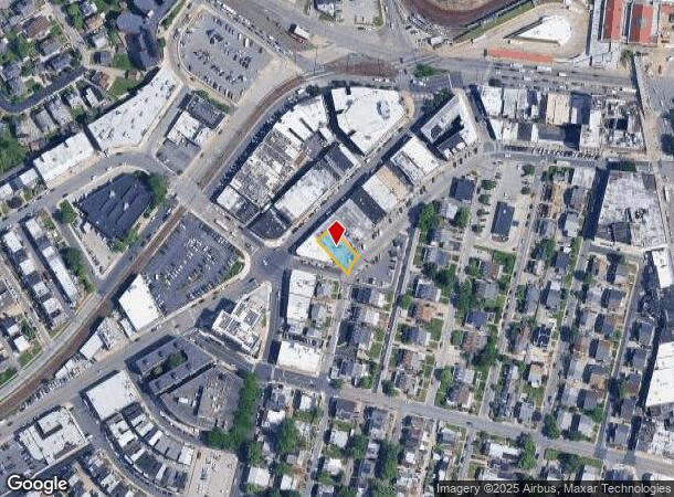
DEMOGRAPHICS near 7050 Garrett Rd
1 Mile
3 Mile
5 Mile
2024 Total Population
48,690
342,733
716,811
2029 Population
47,777
335,807
705,433
Pop Growth 2024-2029
(1.88%)
(2.02%)
(1.59%)
Average Age
37
38
38
2024 Total Households
17,564
133,034
291,327
HH Growth 2024-2029
(2.01%)
(2.25%)
(1.80%)
Median Household Inc
$48,121
$51,579
$59,867
Avg Household Size
2.60
2.50
2.30
2024 Avg HH Vehicles
1.00
1.00
1.00
Median Home Value
$136,335
$176,970
$241,237
Median Year Built
1947
1947
1949
Nearby Places
Map Layers
Map Styles
 Street
 Aerial
- Restaurants
- Banks
- Shops
- Fitness
- Groceries
PUBLIC TRANSPORTATION
TRANSIT/SUBWAY
Fairfield Avenue (Route 101 - Southeastern Pennsylvania Transportation Authority Rapid Transit (SEPTA Subway & Trolley), Route 102 - Southeastern Pennsylvania Transportation Authority Rapid Transit (SEPTA Subway & Trolley))
DRIVE
WALK
Distance
Fairfield Avenue (Route 101 - Southeastern Pennsylvania Transportation Authority Rapid Transit (SEPTA Subway & Trolley), Route 102 - Southeastern Pennsylvania Transportation Authority Rapid Transit (SEPTA Subway & Trolley))
1 min
3 min
0.1 mi
Walnut Street (Route 101 - Southeastern Pennsylvania Transportation Authority Rapid Transit (SEPTA Subway & Trolley), Route 102 - Southeastern Pennsylvania Transportation Authority Rapid Transit (SEPTA Subway & Trolley))
DRIVE
WALK
Distance
Walnut Street (Route 101 - Southeastern Pennsylvania Transportation Authority Rapid Transit (SEPTA Subway & Trolley), Route 102 - Southeastern Pennsylvania Transportation Authority Rapid Transit (SEPTA Subway & Trolley))
2 min
6 min
0.3 mi
Avon Road (Route 101 - Southeastern Pennsylvania Transportation Authority Rapid Transit (SEPTA Subway & Trolley), Route 102 - Southeastern Pennsylvania Transportation Authority Rapid Transit (SEPTA Subway & Trolley))
DRIVE
WALK
Distance
Avon Road (Route 101 - Southeastern Pennsylvania Transportation Authority Rapid Transit (SEPTA Subway & Trolley), Route 102 - Southeastern Pennsylvania Transportation Authority Rapid Transit (SEPTA Subway & Trolley))
2 min
9 min
0.5 mi
Hilltop Road (Route 101 - Southeastern Pennsylvania Transportation Authority Rapid Transit (SEPTA Subway & Trolley), Route 102 - Southeastern Pennsylvania Transportation Authority Rapid Transit (SEPTA Subway & Trolley))
DRIVE
WALK
Distance
Hilltop Road (Route 101 - Southeastern Pennsylvania Transportation Authority Rapid Transit (SEPTA Subway & Trolley), Route 102 - Southeastern Pennsylvania Transportation Authority Rapid Transit (SEPTA Subway & Trolley))
3 min
13 min
0.7 mi
Millbourne (Market-Frankford Line - Southeastern Pennsylvania Transportation Authority Rapid Transit (SEPTA Subway & Trolley))
DRIVE
WALK
Distance
Millbourne (Market-Frankford Line - Southeastern Pennsylvania Transportation Authority Rapid Transit (SEPTA Subway & Trolley))
5 min
14 min
0.7 mi
COMMUTER RAIL
Fernwood-Yeadon (R3 - Southeastern Pennsylvania Transportation Authority Regional Rail (SEPTA Regional Rail))
DRIVE
WALK
Distance
Fernwood-Yeadon (R3 - Southeastern Pennsylvania Transportation Authority Regional Rail (SEPTA Regional Rail))
6 min
1.9 mi
Angora (R3 - Southeastern Pennsylvania Transportation Authority Regional Rail (SEPTA Regional Rail))
DRIVE
WALK
Distance
Angora (R3 - Southeastern Pennsylvania Transportation Authority Regional Rail (SEPTA Regional Rail))
8 min
2.6 mi
AIRPORT
Philadelphia International
DRIVE
WALK
Distance
Philadelphia International
22 min
8.0 mi
Trenton Mercer
DRIVE
WALK
Distance
Trenton Mercer
64 min
40.3 mi
Freight Ports
South Jersey Port
DRIVE
WALK
Distance
South Jersey Port
24 min
10.9 mi
Nearby Properties
Address
Land Use
TOTAL SIZE
Lot Size
Zoning
Address
Land Use
TOTAL SIZE
Lot Size
Zoning
2,178,860 SF
48.65 AC
R3
Address
Land Use
TOTAL SIZE
Lot Size
Zoning
158,496 SF
Address
Land Use
TOTAL SIZE
Lot Size
Zoning
Address
Land Use
TOTAL SIZE
Lot Size
Zoning
175,069 SF
2.20 AC
CMX3
Address
Land Use
TOTAL SIZE
Lot Size
Zoning
76,614 SF
1.53 AC
CMX3
Address
Land Use
TOTAL SIZE
Lot Size
Zoning
1,600 SF
177.07 AC
SPPOA
Address
Land Use
TOTAL SIZE
Lot Size
Zoning
232,225 SF
0.86 AC
CMX4
Address
Land Use
TOTAL SIZE
Lot Size
Zoning
511,806 SF
1.70 AC
RM4
Address
Land Use
TOTAL SIZE
Lot Size
Zoning
15,660 SF
56.60 AC
Address
Land Use
TOTAL SIZE
Lot Size
Zoning
461,834 SF
4.73 AC
CMX3
Address
Land Use
TOTAL SIZE
Lot Size
Zoning
374,105 SF
5.63 AC
CMX3
Address
Land Use
TOTAL SIZE
Lot Size
Zoning
448,864 SF
32.89 AC
Address
Land Use
TOTAL SIZE
Lot Size
Zoning
343,158 SF
12 AC
CMX4
Address
Land Use
TOTAL SIZE
Lot Size
Zoning
1,935,584 SF
11.11 AC
ICMX
Address
Land Use
TOTAL SIZE
Lot Size
Zoning
112,268 SF
28.27 AC
Address
Land Use
TOTAL SIZE
Lot Size
Zoning
281,508 SF
18.93 AC
SPINS
Address
Land Use
TOTAL SIZE
Lot Size
Zoning
197,925 SF
1.96 AC
RM4
Address
Land Use
TOTAL SIZE
Lot Size
Zoning
475,984 SF
5.74 AC
ICMX
Address
Land Use
TOTAL SIZE
Lot Size
Zoning
82,153 SF
13.97 AC
Address
Land Use
TOTAL SIZE
Lot Size
Zoning
190,150 SF
0.77 AC
RM1
Address
Land Use
TOTAL SIZE
Lot Size
Zoning
1.65 AC
CMX3
Address
Land Use
TOTAL SIZE
Lot Size
Zoning
178,878 SF
0.23 AC
CMX4
Address
Land Use
TOTAL SIZE
Lot Size
Zoning
95,895 SF
2.94 AC
RTA1
Address
Land Use
TOTAL SIZE
Lot Size
Zoning
180,000 SF
0.57 AC
RM4
Address
Land Use
TOTAL SIZE
Lot Size
Zoning
7.96 AC
Address
Land Use
TOTAL SIZE
Lot Size
Zoning
164,640 SF
0.62 AC
CMX4
Address
Land Use
TOTAL SIZE
Lot Size
Zoning
134,750 SF
0.52 AC
CMX4
Address
Land Use
TOTAL SIZE
Lot Size
Zoning
111,000 SF
0.47 AC
CMX4
Address
Land Use
TOTAL SIZE
Lot Size
Zoning
390,000 SF
17.57 AC
SPINS
Address
Land Use
TOTAL SIZE
Lot Size
Zoning
321,744 SF
14 AC
C1
The World's #1 Commercial Real Estate Marketplace
Connect with us
© 2026 CoStar Group
The information above has been obtained from sources believed reliable. While we do not doubt its accuracy we have not verified it and make no guarantee, warranty or representation about it. It is your responsibility to independently confirm its accuracy and completeness. Any projections, opinions, assumptions, or estimates used are for example only and do not represent the current or future performance of the property. The value of this transaction to you depends on tax and other factors which should be evaluated by your tax, financial, and legal advisors. You and your advisors should conduct a careful, independent investigation of the property to determine to your satisfaction the suitability of the property for your needs.