Property Record
50 Barnwood Dr, Asheville, NC 28804


NEARBY LISTINGS FOR SALE OR LEASE
-
-
View all Asheville listings for sale on LoopNet.com
Property Detail
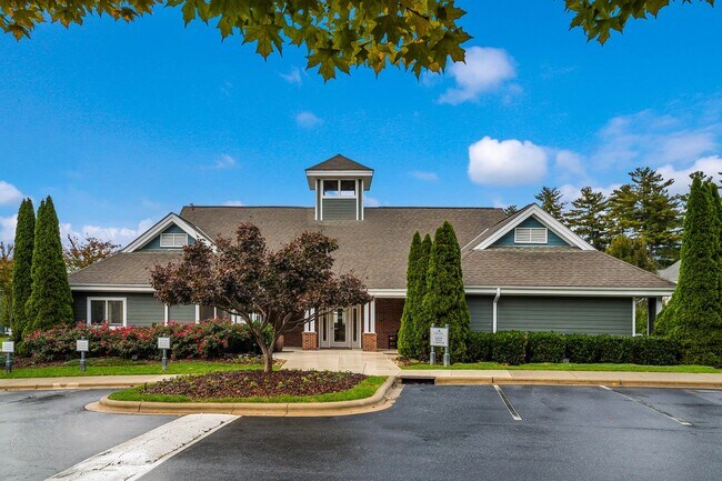
50 Barnwood Dr
Asheville, NC
Rcg Woodland Hills Llc
9731-68-6152-00000
SUBDIV: RCG WOODLAND HILLS LLC BLOCK: LOT: BOUNDARY PLAT SECTION: PLAT: 0134-0107
Apartment
Buncombe
X
North Carolina
3700973100J
6
2024
16.91 AC
2025
Woodfin
001602
Asheville
75,122 SF
DEMOGRAPHICS near 50 Barnwood Dr
1 Mile
3 Mile
5 Mile
2024 Total Population
3,096
21,686
57,577
2029 Population
3,214
22,603
59,811
Pop Growth 2024-2029
+ 3.81%
+ 4.23%
+ 3.88%
Average Age
44
46
44
2024 Total Households
1,429
9,401
24,364
HH Growth 2024-2029
+ 3.22%
+ 3.79%
+ 3.38%
Median Household Inc
$63,119
$78,429
$71,894
Avg Household Size
2.10
2.20
2.20
2024 Avg HH Vehicles
2.00
2.00
2.00
Median Home Value
$392,156
$398,658
$392,939
Median Year Built
1991
1988
1982
Nearby Places
Map Layers
Map Styles
 Street
 Aerial
- Restaurants
- Banks
- Shops
- Fitness
- Groceries
PUBLIC TRANSPORTATION
AIRPORT
Asheville Regional
DRIVE
WALK
Distance
Asheville Regional
28 min
20.6 mi
Freight Ports
North Charleston Terminal
DRIVE
WALK
Distance
North Charleston Terminal
300 min
264.3 mi
Nearby Properties
Address
Land Use
TOTAL SIZE
Lot Size
Zoning
Address
Land Use
TOTAL SIZE
Lot Size
Zoning
103,525 SF
18.23 AC
SHOPPING
Address
Land Use
TOTAL SIZE
Lot Size
Zoning
101,676 SF
19.40 AC
EMP
Address
Land Use
TOTAL SIZE
Lot Size
Zoning
153,383 SF
10.78 AC
SHOPPING
Address
Land Use
TOTAL SIZE
Lot Size
Zoning
70,312 SF
16.85 AC
I-1
Address
Land Use
TOTAL SIZE
Lot Size
Zoning
108,948 SF
24.68 AC
R-3
Address
Land Use
TOTAL SIZE
Lot Size
Zoning
64,521 SF
14.16 AC
R-3
Address
Land Use
TOTAL SIZE
Lot Size
Zoning
68,691 SF
131.92 AC
HEAVY
Address
Land Use
TOTAL SIZE
Lot Size
Zoning
52,470 SF
10.50 AC
I-1
Address
Land Use
TOTAL SIZE
Lot Size
Zoning
134,304 SF
16.10 AC
C-2
Address
Land Use
TOTAL SIZE
Lot Size
Zoning
61,043 SF
6.89 AC
SHOPPING
Address
Land Use
TOTAL SIZE
Lot Size
Zoning
51,555 SF
8.34 AC
R-1
Address
Land Use
TOTAL SIZE
Lot Size
Zoning
187,648 SF
18.85 AC
I-1
Address
Land Use
TOTAL SIZE
Lot Size
Zoning
414,493 SF
34.02 AC
I-1
Address
Land Use
TOTAL SIZE
Lot Size
Zoning
139,265 SF
14.97 AC
I-1
Address
Land Use
TOTAL SIZE
Lot Size
Zoning
49,898 SF
6.85 AC
R-10
Address
Land Use
TOTAL SIZE
Lot Size
Zoning
98,003 SF
11.96 AC
C-2
Address
Land Use
TOTAL SIZE
Lot Size
Zoning
339,426 SF
12.49 AC
SHOPPING
Address
Land Use
TOTAL SIZE
Lot Size
Zoning
28,247 SF
3.22 AC
C-2
Address
Land Use
TOTAL SIZE
Lot Size
Zoning
47,374 SF
6.84 AC
C-2
Address
Land Use
TOTAL SIZE
Lot Size
Zoning
166,387 SF
23.84 AC
I-1
Address
Land Use
TOTAL SIZE
Lot Size
Zoning
97,200 SF
13.50 AC
LIGHT
Address
Land Use
TOTAL SIZE
Lot Size
Zoning
14,380 SF
2.14 AC
SHOPPING
Address
Land Use
TOTAL SIZE
Lot Size
Zoning
35,776 SF
13.26 AC
R-1
Address
Land Use
TOTAL SIZE
Lot Size
Zoning
15,094 SF
2.48 AC
SHOPPING
Address
Land Use
TOTAL SIZE
Lot Size
Zoning
7.54 AC
R-1
Address
Land Use
TOTAL SIZE
Lot Size
Zoning
38,346 SF
4.96 AC
R-1
Address
Land Use
TOTAL SIZE
Lot Size
Zoning
27,832 SF
7.96 AC
SHOPPING
Address
Land Use
TOTAL SIZE
Lot Size
Zoning
20,816 SF
3.48 AC
R-1
Address
Land Use
TOTAL SIZE
Lot Size
Zoning
35,844 SF
1.58 AC
SHOPPING
The World's #1 Commercial Real Estate Marketplace
Connect with us
© 2026 CoStar Group
The information above has been obtained from sources believed reliable. While we do not doubt its accuracy we have not verified it and make no guarantee, warranty or representation about it. It is your responsibility to independently confirm its accuracy and completeness. Any projections, opinions, assumptions, or estimates used are for example only and do not represent the current or future performance of the property. The value of this transaction to you depends on tax and other factors which should be evaluated by your tax, financial, and legal advisors. You and your advisors should conduct a careful, independent investigation of the property to determine to your satisfaction the suitability of the property for your needs.