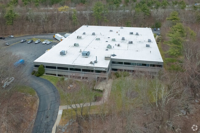
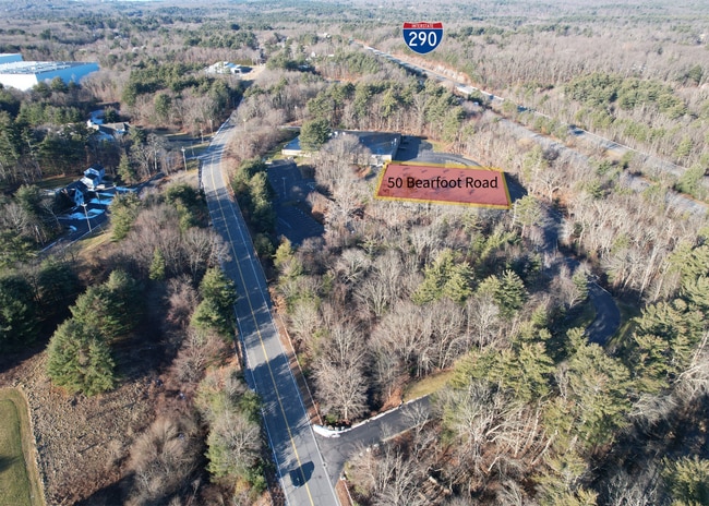
Property Record
50 Bearfoot Rd, Northborough, MA 01532

NEARBY LISTINGS FOR SALE OR LEASE
Property Detail
50 Bearfoot Rd
NBOR-000290-000000-000033
Worcester
Industrialgeneral
Massachusetts
X
33
25027C0634F
8.54 AC
2025
The Boroughs
2025
Boston
740102
Worcester, MA-CT
67,340 SF
DEMOGRAPHICS near 50 Bearfoot Rd
1 Mile
3 Mile
5 Mile
2024 Total Population
2,596
20,003
80,437
2029 Population
2,582
20,031
80,072
Pop Growth 2024-2029
(0.54%)
+ 0.14%
(0.45%)
Average Age
42
42
41
2024 Total Households
927
7,555
30,920
HH Growth 2024-2029
(0.65%)
+ 0.20%
(0.47%)
Median Household Inc
$163,851
$131,974
$110,607
Avg Household Size
2.80
2.60
2.50
2024 Avg HH Vehicles
2.00
2.00
2.00
Median Home Value
$567,888
$548,387
$492,367
Median Year Built
1982
1982
1976
Nearby Places
Map Layers
Map Styles
 Street
 Aerial
- Restaurants
- Banks
- Shops
- Fitness
- Groceries
PUBLIC TRANSPORTATION
COMMUTER RAIL
Westborough (Framingham/Worcester Line - Massachusetts Bay Transportation Authority Commuter Rail (Purple Line))
DRIVE
WALK
Distance
Westborough (Framingham/Worcester Line - Massachusetts Bay Transportation Authority Commuter Rail (Purple Line))
17 min
6.6 mi
Grafton (Framingham/Worcester Line - Massachusetts Bay Transportation Authority Commuter Rail (Purple Line))
DRIVE
WALK
Distance
Grafton (Framingham/Worcester Line - Massachusetts Bay Transportation Authority Commuter Rail (Purple Line))
19 min
8.9 mi
AIRPORT
Worcester Regional
DRIVE
WALK
Distance
Worcester Regional
29 min
17.7 mi
General Edward Lawrence Logan International
DRIVE
WALK
Distance
General Edward Lawrence Logan International
58 min
42.1 mi
Freight Ports
Port of Boston
DRIVE
WALK
Distance
Port of Boston
56 min
40.5 mi
SALE & LEASE HISTORY
LISTING DATE
SALE/LEASE

Feb 06, 2024
For Sale
Nearby Properties
Address
Land Use
TOTAL SIZE
Lot Size
Zoning
Address
Land Use
TOTAL SIZE
Lot Size
Zoning
71.70 AC
LI
Address
Land Use
TOTAL SIZE
Lot Size
Zoning
339,553 SF
42.94 AC
RC
Address
Land Use
TOTAL SIZE
Lot Size
Zoning
18.73 AC
I
Address
Land Use
TOTAL SIZE
Lot Size
Zoning
24.39 AC
Address
Land Use
TOTAL SIZE
Lot Size
Zoning
657,045 SF
46.52 AC
LI
Address
Land Use
TOTAL SIZE
Lot Size
Zoning
554,193 SF
52.56 AC
I
Address
Land Use
TOTAL SIZE
Lot Size
Zoning
300,989 SF
66.90 AC
I
Address
Land Use
TOTAL SIZE
Lot Size
Zoning
24.95 AC
I
Address
Land Use
TOTAL SIZE
Lot Size
Zoning
314,677 SF
97.28 AC
Address
Land Use
TOTAL SIZE
Lot Size
Zoning
113.78 AC
I
Address
Land Use
TOTAL SIZE
Lot Size
Zoning
56.73 AC
LI
Address
Land Use
TOTAL SIZE
Lot Size
Zoning
260,605 SF
29 AC
I
Address
Land Use
TOTAL SIZE
Lot Size
Zoning
220,336 SF
24.65 AC
I
Address
Land Use
TOTAL SIZE
Lot Size
Zoning
299,149 SF
28.81 AC
I
Address
Land Use
TOTAL SIZE
Lot Size
Zoning
209,220 SF
19.33 AC
I
Address
Land Use
TOTAL SIZE
Lot Size
Zoning
283,750 SF
27.03 AC
LI
Address
Land Use
TOTAL SIZE
Lot Size
Zoning
216,218 SF
97.33 AC
Address
Land Use
TOTAL SIZE
Lot Size
Zoning
167,438 SF
23.82 AC
I
Address
Land Use
TOTAL SIZE
Lot Size
Zoning
47,301 SF
8.07 AC
Address
Land Use
TOTAL SIZE
Lot Size
Zoning
199,892 SF
46.51 AC
Address
Land Use
TOTAL SIZE
Lot Size
Zoning
136,790 SF
11.64 AC
B
Address
Land Use
TOTAL SIZE
Lot Size
Zoning
174,315 SF
29.04 AC
B
Address
Land Use
TOTAL SIZE
Lot Size
Zoning
118,128 SF
22.50 AC
I
Address
Land Use
TOTAL SIZE
Lot Size
Zoning
132,659 SF
11.67 AC
I
Address
Land Use
TOTAL SIZE
Lot Size
Zoning
143,126 SF
24.06 AC
I
Address
Land Use
TOTAL SIZE
Lot Size
Zoning
120,146 SF
7.33 AC
LI
Address
Land Use
TOTAL SIZE
Lot Size
Zoning
278,442 SF
5.68 AC
I
Address
Land Use
TOTAL SIZE
Lot Size
Zoning
83,180 SF
24 AC
I
Address
Land Use
TOTAL SIZE
Lot Size
Zoning
32,082 SF
3.70 AC
Address
Land Use
TOTAL SIZE
Lot Size
Zoning
10.70 AC
RR
The World's #1 Commercial Real Estate Marketplace
Connect with us
© 2025 CoStar Group
The information above has been obtained from sources believed reliable. While we do not doubt its accuracy we have not verified it and make no guarantee, warranty or representation about it. It is your responsibility to independently confirm its accuracy and completeness. Any projections, opinions, assumptions, or estimates used are for example only and do not represent the current or future performance of the property. The value of this transaction to you depends on tax and other factors which should be evaluated by your tax, financial, and legal advisors. You and your advisors should conduct a careful, independent investigation of the property to determine to your satisfaction the suitability of the property for your needs.