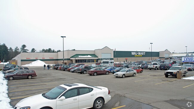
Property Record
50 Boulder Way, Biddeford, ME 04005
NEARBY LISTINGS FOR SALE OR LEASE
Property Detail
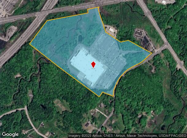
50 Boulder Way
BIDD-000002-000000-000058
York
Departmentstore
Maine
A
58
23031C0451G
44.47 AC
2024
York County
2024
Portland/South Portland
025100
Portland-South Portland, ME
197,008 SF
DEMOGRAPHICS near 50 Boulder Way
1 mile
3 mile
5 mile
2024 Total Population
333
20,557
40,877
2029 Population
349
21,525
42,891
Pop Growth 2024-2029
+ 4.80%
+ 4.71%
+ 4.93%
Average Age
43
41
42
2024 Total Households
130
9,117
17,473
HH Growth 2024-2029
+ 4.62%
+ 4.75%
+ 4.90%
Median Household Inc
$88,888
$56,446
$65,085
Avg Household Size
2.50
2.20
2.20
2024 Avg HH Vehicles
3.00
2.00
2.00
Median Home Value
$331,481
$308,938
$324,842
Median Year Built
1982
1961
1974
Nearby Places
Map Layers
Map Styles
 Street
 Aerial
Transit
 Traffic
 Biking
Places
Listings with unknown addresses are not visible on the map
- Restaurants
- Banks
- Shops
- Fitness
- Groceries
PUBLIC TRANSPORTATION
COMMUTER RAIL
Saco Amtrak Station (Downeaster - Amtrak)
Drive
Walk
Distance
Saco Amtrak Station (Downeaster - Amtrak)
7 min
3.4 mi
Old Orchard Beach Amtrak (Downeaster - Amtrak)
Drive
Walk
Distance
Old Orchard Beach Amtrak (Downeaster - Amtrak)
15 min
9.2 mi
AIRPORT
Portland International Jetport
Drive
Walk
Distance
Portland International Jetport
24 min
16.6 mi
Freight Ports
Portland, ME
Drive
Walk
Distance
Portland, ME
25 min
19.2 mi
Nearby Properties
Address
Land Use
TOTAL SIZE
Lot Size
Zoning
Address
Land Use
TOTAL SIZE
Lot Size
Zoning
25.99 AC
M
Address
Land Use
TOTAL SIZE
Lot Size
Zoning
233,280 SF
8.40 AC
MSRD3
Address
Land Use
TOTAL SIZE
Lot Size
Zoning
230,822 SF
3.50 AC
MSRD3
Address
Land Use
TOTAL SIZE
Lot Size
Zoning
8.47 AC
R1B
Address
Land Use
TOTAL SIZE
Lot Size
Zoning
69,442 SF
1.12 AC
B2
Address
Land Use
TOTAL SIZE
Lot Size
Zoning
Address
Land Use
TOTAL SIZE
Lot Size
Zoning
135,080 SF
18.93 AC
B2
Address
Land Use
TOTAL SIZE
Lot Size
Zoning
136,033 SF
15.71 AC
B2
Address
Land Use
TOTAL SIZE
Lot Size
Zoning
262,580 SF
40.10 AC
I1
Address
Land Use
TOTAL SIZE
Lot Size
Zoning
224,607 SF
5.07 AC
B-4
Address
Land Use
TOTAL SIZE
Lot Size
Zoning
91,642 SF
21.43 AC
R1A
Address
Land Use
TOTAL SIZE
Lot Size
Zoning
122,465 SF
0.51 AC
MSRD3
Address
Land Use
TOTAL SIZE
Lot Size
Zoning
136,348 SF
1.57 AC
MSRD3
Address
Land Use
TOTAL SIZE
Lot Size
Zoning
17.50 AC
B2
Address
Land Use
TOTAL SIZE
Lot Size
Zoning
119,500 SF
28.24 AC
B2
Address
Land Use
TOTAL SIZE
Lot Size
Zoning
35,008 SF
10.19 AC
RF SR1
Address
Land Use
TOTAL SIZE
Lot Size
Zoning
72,508 SF
2.57 AC
MSRD3
Address
Land Use
TOTAL SIZE
Lot Size
Zoning
77,406 SF
16 AC
R1A
Address
Land Use
TOTAL SIZE
Lot Size
Zoning
15.36 AC
I1
Address
Land Use
TOTAL SIZE
Lot Size
Zoning
64,788 SF
25.50 AC
R1A
Address
Land Use
TOTAL SIZE
Lot Size
Zoning
75,382 SF
0.85 AC
MSRD3
Address
Land Use
TOTAL SIZE
Lot Size
Zoning
108,730 SF
0.52 AC
MSRD3
Address
Land Use
TOTAL SIZE
Lot Size
Zoning
9.62 AC
B2
Address
Land Use
TOTAL SIZE
Lot Size
Zoning
139,607 SF
13.20 AC
I1
Address
Land Use
TOTAL SIZE
Lot Size
Zoning
89,540 SF
0.44 AC
MSRD3
Address
Land Use
TOTAL SIZE
Lot Size
Zoning
41,436 SF
6.61 AC
I3
Address
Land Use
TOTAL SIZE
Lot Size
Zoning
60,268 SF
1.16 AC
MSRD3
Address
Land Use
TOTAL SIZE
Lot Size
Zoning
51,376 SF
7.12 AC
I3
Address
Land Use
TOTAL SIZE
Lot Size
Zoning
2.37 AC
W2
The World's #1 Commercial Real Estate Marketplace
Connect with us
© 2026 CoStar Group
The information above has been obtained from sources believed reliable. While we do not doubt its accuracy we have not verified it and make no guarantee, warranty or representation about it. It is your responsibility to independently confirm its accuracy and completeness. Any projections, opinions, assumptions, or estimates used are for example only and do not represent the current or future performance of the property. The value of this transaction to you depends on tax and other factors which should be evaluated by your tax, financial, and legal advisors. You and your advisors should conduct a careful, independent investigation of the property to determine to your satisfaction the suitability of the property for your needs.