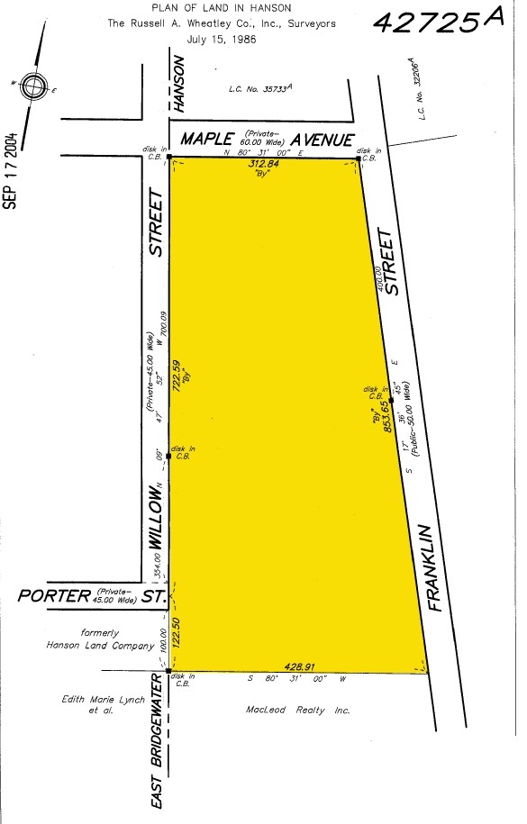
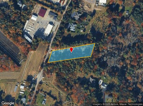
Property Record
50 Franklin St, Hanson, MA 02341
NEARBY LISTINGS FOR SALE OR LEASE
Property Detail
50 Franklin St
Commercialofficeresidentialmixeduse
Plymouth
X
Massachusetts
25023C0192J
2 AC
2025
Route 3 South
2025
Boston
522102
Boston-Cambridge-Newton, MA-NH
1,038 SF
HANS-000045-000000-000003
DEMOGRAPHICS near 50 Franklin St
1 Mile
3 Mile
5 Mile
2024 Total Population
1,613
18,725
76,496
2029 Population
1,623
18,709
76,424
Pop Growth 2024-2029
+ 0.62%
(0.09%)
(0.09%)
Average Age
43
43
41
2024 Total Households
583
6,848
26,852
HH Growth 2024-2029
+ 0.51%
(0.18%)
(0.21%)
Median Household Inc
$126,685
$111,119
$110,272
Avg Household Size
2.80
2.70
2.70
2024 Avg HH Vehicles
2.00
2.00
2.00
Median Home Value
$479,941
$455,124
$452,853
Median Year Built
1987
1975
1971
Nearby Places
Map Layers
Map Styles
 Street
 Aerial
- Restaurants
- Banks
- Shops
- Fitness
- Groceries
PUBLIC TRANSPORTATION
COMMUTER RAIL
Hanson (Kingston/Plymouth Line - Massachusetts Bay Transportation Authority Commuter Rail (Purple Line))
DRIVE
WALK
Distance
Hanson (Kingston/Plymouth Line - Massachusetts Bay Transportation Authority Commuter Rail (Purple Line))
2 min
1.2 mi
Whitman (Kingston/Plymouth Line - Massachusetts Bay Transportation Authority Commuter Rail (Purple Line))
DRIVE
WALK
Distance
Whitman (Kingston/Plymouth Line - Massachusetts Bay Transportation Authority Commuter Rail (Purple Line))
7 min
3.5 mi
AIRPORT
General Edward Lawrence Logan International
DRIVE
WALK
Distance
General Edward Lawrence Logan International
46 min
29.3 mi
Freight Ports
Port of Boston
DRIVE
WALK
Distance
Port of Boston
44 min
27.1 mi
Nearby Properties
Address
Land Use
TOTAL SIZE
Lot Size
Zoning
Address
Land Use
TOTAL SIZE
Lot Size
Zoning
69.93 AC
100
Address
Land Use
TOTAL SIZE
Lot Size
Zoning
47.64 AC
100
Address
Land Use
TOTAL SIZE
Lot Size
Zoning
412,500 SF
48.94 AC
100
Address
Land Use
TOTAL SIZE
Lot Size
Zoning
99,138 SF
83.32 AC
100
Address
Land Use
TOTAL SIZE
Lot Size
Zoning
117,950 SF
26 AC
100
Address
Land Use
TOTAL SIZE
Lot Size
Zoning
69,184 SF
7.90 AC
100
Address
Land Use
TOTAL SIZE
Lot Size
Zoning
49,295 SF
6.02 AC
100
Address
Land Use
TOTAL SIZE
Lot Size
Zoning
64,168 SF
10 AC
100
Address
Land Use
TOTAL SIZE
Lot Size
Zoning
43.94 AC
100
Address
Land Use
TOTAL SIZE
Lot Size
Zoning
16.12 AC
100
Address
Land Use
TOTAL SIZE
Lot Size
Zoning
2,400 SF
8.17 AC
100
Address
Land Use
TOTAL SIZE
Lot Size
Zoning
78,601 SF
6.83 AC
100
Address
Land Use
TOTAL SIZE
Lot Size
Zoning
38,179 SF
45.33 AC
100
Address
Land Use
TOTAL SIZE
Lot Size
Zoning
51,280 SF
3.90 AC
100
Address
Land Use
TOTAL SIZE
Lot Size
Zoning
8.20 AC
100
Address
Land Use
TOTAL SIZE
Lot Size
Zoning
5.04 AC
A2
Address
Land Use
TOTAL SIZE
Lot Size
Zoning
57.50 AC
100
Address
Land Use
TOTAL SIZE
Lot Size
Zoning
1,640 SF
854.31 AC
100
Address
Land Use
TOTAL SIZE
Lot Size
Zoning
40,240 SF
5 AC
TYPI
Address
Land Use
TOTAL SIZE
Lot Size
Zoning
14,464 SF
3.94 AC
100
Address
Land Use
TOTAL SIZE
Lot Size
Zoning
3.10 AC
100
Address
Land Use
TOTAL SIZE
Lot Size
Zoning
54,705 SF
14.77 AC
100
Address
Land Use
TOTAL SIZE
Lot Size
Zoning
30,000 SF
4.36 AC
100
Address
Land Use
TOTAL SIZE
Lot Size
Zoning
19,923 SF
4.29 AC
I
Address
Land Use
TOTAL SIZE
Lot Size
Zoning
56,750 SF
2.85 AC
COMMER
Address
Land Use
TOTAL SIZE
Lot Size
Zoning
32,568 SF
1.89 AC
FLEX O
Address
Land Use
TOTAL SIZE
Lot Size
Zoning
64,000 SF
3.25 AC
Address
Land Use
TOTAL SIZE
Lot Size
Zoning
34,136 SF
3.45 AC
100
Address
Land Use
TOTAL SIZE
Lot Size
Zoning
22.97 AC
100
Address
Land Use
TOTAL SIZE
Lot Size
Zoning
63.40 AC
100
The World's #1 Commercial Real Estate Marketplace
Connect with us
© 2025 CoStar Group
The information above has been obtained from sources believed reliable. While we do not doubt its accuracy we have not verified it and make no guarantee, warranty or representation about it. It is your responsibility to independently confirm its accuracy and completeness. Any projections, opinions, assumptions, or estimates used are for example only and do not represent the current or future performance of the property. The value of this transaction to you depends on tax and other factors which should be evaluated by your tax, financial, and legal advisors. You and your advisors should conduct a careful, independent investigation of the property to determine to your satisfaction the suitability of the property for your needs.