Property Record
50 Fulkerson Way, Saint Augustine, FL 32086
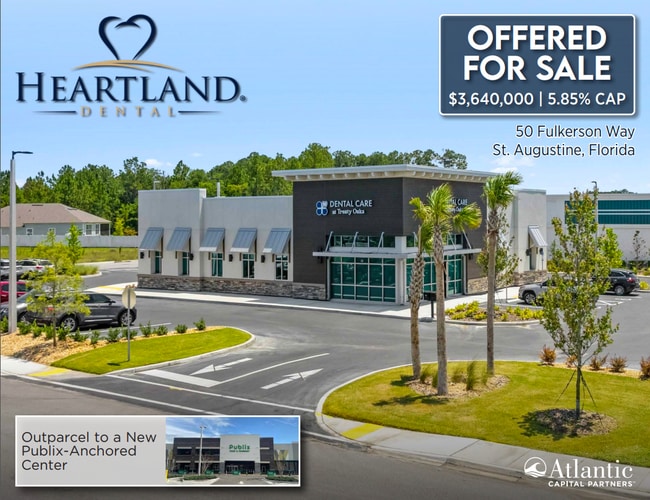

Property Detail
50 Fulkerson Way
Jacksonville, FL
PT OF N1/2 OF NE1/4 LYING SE OF SR207 OR6047/257
136000-0002
ST. JOHNS
Commercialnec
Florida
2025
0.89 AC
2026
St Johns County
021207
Jacksonville (Florida)
4,320 SF
NEARBY LISTINGS FOR SALE OR LEASE
DEMOGRAPHICS near 50 Fulkerson Way
1 mile
3 mile
5 mile
2025 Total Population
4,066
25,325
64,122
2030 Population
4,784
29,454
74,400
Pop Growth 2025-2030
+ 17.66%
+ 16.30%
+ 16.03%
Average Age
44
45
46
2025 Total Households
1,587
10,374
27,405
HH Growth 2025-2030
+ 18.08%
+ 16.67%
+ 16.45%
Median Household Inc
$88,541
$76,558
$73,513
Avg Household Size
2.50
2.40
2.20
2025 Avg HH Vehicles
2.00
2.00
2.00
Median Home Value
$446,982
$398,786
$376,165
Median Year Built
2010
2003
2000
Nearby Places
Map Layers
Map Styles
 Street
 Aerial
Layers
 Traffic
 Biking
Places
Listings with unknown addresses are not visible on the map
- Restaurants
- Banks
- Shops
- Fitness
- Groceries
SALE & LEASE HISTORY
LISTING DATE
SALE/LEASE

Jun 26, 2024
For Sale
Nearby Properties
Address
Land Use
TOTAL SIZE
Lot Size
Zoning
Address
Land Use
TOTAL SIZE
Lot Size
Zoning
117,686 SF
14.52 AC
CI
Address
Land Use
TOTAL SIZE
Lot Size
Zoning
15,400 SF
40.38 AC
PUD
Address
Land Use
TOTAL SIZE
Lot Size
Zoning
237,460 SF
66.83 AC
Address
Land Use
TOTAL SIZE
Lot Size
Zoning
311,794 SF
39.89 AC
Address
Land Use
TOTAL SIZE
Lot Size
Zoning
118,694 SF
20.03 AC
Address
Land Use
TOTAL SIZE
Lot Size
Zoning
262,617 SF
37.08 AC
PUD
Address
Land Use
TOTAL SIZE
Lot Size
Zoning
25,155 SF
32.46 AC
PUD
Address
Land Use
TOTAL SIZE
Lot Size
Zoning
52,990 SF
5.82 AC
OR
Address
Land Use
TOTAL SIZE
Lot Size
Zoning
161,211 SF
21.70 AC
PUD
Address
Land Use
TOTAL SIZE
Lot Size
Zoning
18,174 SF
25 AC
PUD
Address
Land Use
TOTAL SIZE
Lot Size
Zoning
119,853 SF
21.34 AC
Address
Land Use
TOTAL SIZE
Lot Size
Zoning
65,082 SF
22.11 AC
Address
Land Use
TOTAL SIZE
Lot Size
Zoning
47,385 SF
12.36 AC
Address
Land Use
TOTAL SIZE
Lot Size
Zoning
2.46 AC
CI
Address
Land Use
TOTAL SIZE
Lot Size
Zoning
91,500 SF
10.62 AC
OR/CHT
Address
Land Use
TOTAL SIZE
Lot Size
Zoning
33,602 SF
8.13 AC
Address
Land Use
TOTAL SIZE
Lot Size
Zoning
202,143 SF
22.30 AC
OR
Address
Land Use
TOTAL SIZE
Lot Size
Zoning
6,436 SF
13.09 AC
OR
Address
Land Use
TOTAL SIZE
Lot Size
Zoning
202,733 SF
23.38 AC
PUD
Address
Land Use
TOTAL SIZE
Lot Size
Zoning
196,920 SF
17.46 AC
PSD
Address
Land Use
TOTAL SIZE
Lot Size
Zoning
138,830 SF
15 AC
OR
Address
Land Use
TOTAL SIZE
Lot Size
Zoning
700 SF
3.82 AC
CG
Address
Land Use
TOTAL SIZE
Lot Size
Zoning
Address
Land Use
TOTAL SIZE
Lot Size
Zoning
25,894 SF
8.34 AC
OR
Address
Land Use
TOTAL SIZE
Lot Size
Zoning
39,901 SF
8.27 AC
Address
Land Use
TOTAL SIZE
Lot Size
Zoning
1,210 SF
3.16 AC
CG
Address
Land Use
TOTAL SIZE
Lot Size
Zoning
30.66 AC
OR
Address
Land Use
TOTAL SIZE
Lot Size
Zoning
84,817 SF
23.98 AC
OR
Address
Land Use
TOTAL SIZE
Lot Size
Zoning
138.21 AC
OR
Address
Land Use
TOTAL SIZE
Lot Size
Zoning
24,732 SF
8.06 AC
The World's #1 Commercial Real Estate Marketplace
Connect with us
© 2026 CoStar Group
The information above has been obtained from sources believed reliable. While we do not doubt its accuracy we have not verified it and make no guarantee, warranty or representation about it. It is your responsibility to independently confirm its accuracy and completeness. Any projections, opinions, assumptions, or estimates used are for example only and do not represent the current or future performance of the property. The value of this transaction to you depends on tax and other factors which should be evaluated by your tax, financial, and legal advisors. You and your advisors should conduct a careful, independent investigation of the property to determine to your satisfaction the suitability of the property for your needs.